State of the Chase Season 2023

Status
Not open for further replies.
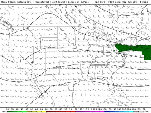
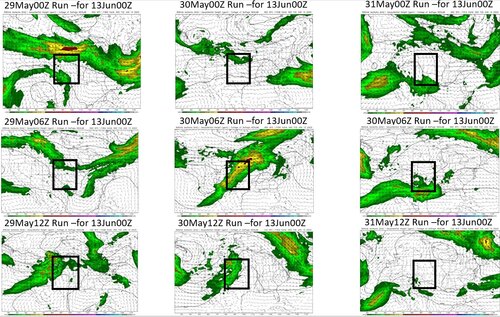
Current chiclet chart is favorable for the period roughly centered around 6/9-6/14 but when I look at the 500mb charts for the same period I just don't see it until the last day or two (a couple of representative charts from the period inserted below). Can anyone explain this?? If it's because the timing of the products is out of sync, then such run-to-run variability alone is reason to discount it...

cfs_bchiclet.png500wh.conus.png500wh.conus (1).png
 
yeah I saw this too this morning on the 00Z that was a pretty radical shift from yesterday, so until I see a consistent trend on knocking out the 8th to 13th like this 00Z did, I am not sure I am going to count it.. 3 days straight of similar patterns showing the 8th to 13th in favorable conditions, I just don't see 1 run just killing that. Just have to keep watching it, and then ask, what in the world of modeling caused such a radical shift when it was trending so consistently. That's a question for the 1's and 0's team. ( chaos ? )
 
I was planning to work remotely out here on the Plains this week and shift my PTO time to next week, but now things are looking a bit better for Wed/Thu/Fri this week. Not great by any means, but somewhat similar to last week, which featured a few good chase days such as the Grady NM tornadic storm last Wed 5/24, a few picturesque supercells in De Baca County NM on Sat 5/27 and a low-contrast tornado near Stratford/Cactus/Sunray TX from an unusual storm featuring new mesos propagating W/NW on a marginal, <2%, no severe weather watch day yesterday 5/28. Part of the Wed-Fri period this week could feature some of the strongest 500mb winds we’ve seen over the past few weeks, although they look to be limited to NM atop limited moisture. But again, that’s similar to last week’s situation but with potentially better shear.

I plan to get some work done today/tomorrow, chase Wed-Fri, and then figure out what I am going to do for next week. At that point, I will have been off from work for most of a two week period. I can stay out here and work remotely, but I can’t take a third consecutive week of vacation to remain in full chase mode. I will have to just try to squeak out a day or two of additional time off only for the higher-end chase days, if any. Or, I can try to position for a target the night before, so I can work most of the day during the chase day and not have to drive too far to the target.
 
I'm not betting on anything beyond the upcoming Wednesday through maybe Sunday period -- which look good. Bad seasons like to gravitate back to crummy set-ups. I'm assuming things might get busy further north during the middle of June as hinted by some models, but that is too much of a gamble for me to stick around after Sunday or Monday. The dust / monsoon / hurricane seasons will be here soon.
 
Thanks @Jeff Duda. Is it fair to say the emphasis on that one particular metric is a limitation of the CFS chiclet chart - for chasing purposes, anyway? I guess the other big limitation for chasers is that the severe risk it highlights could very well be in regions other than the Plains. All of which means that, whenever there is a positive outlook painted by that chart, there is far more downside than upside for chasing!
 
Jeff's charts were yesterdays run. here are todays 00Z for the same time. There is some GFS correlation to these dates. but I think it's just working out, timing of trough entering western US to the exit of upper low over Ontario.
11junscp.png
12junscp.png
13junscp.png
 
Last edited:
but it's becoming apparent that its shifting right in the timing that I mentioned last week.. seems like the 8th -10th is cut off, and its more transitioning to 11-18th now. and maybe that's the models trap to chasing mind set in some ways. you gotta pick a range, but using this period in the forecast is tricky since the models are working out large scale movement/timing. which is why I like to see consistency and correlation on the far side of the CFS/GFS, but you can't even 100% trust that, since as we saw, overnight, one run shocks the system and cuts off 2 days of 8-10 earlier potential. amusing and frustrating all at the same time. lol
 
So I decided to pick a day I was interested in due to some correlations I saw earlier that just appeared and then disappeared. So I decided to capture a run to run visual looking looking at the same FCST time. I overlaid a Box area I was just using as a region, nothing particular about it, I just used as a place for your eye to go and see the seriously wide variations.

Now James Caruso doesn't like probability, but I tend to, mainly to look at the mean over a large number of members, and sure, it's probability but, I can't say for sure all probability is the same, say if you were comparing 4km convective prob blob over your house vs. the probability nationally that wind fields may emulate this pattern. (or, is all probability equal?)
 

Attachments

  • GEFS for 13 Jun 00Z.jpg
    GEFS for 13 Jun 00Z.jpg
    205.7 KB · Views: 0
  • GFS  Run to Run.jpg
    GFS Run to Run.jpg
    554.5 KB · Views: 0
So I decided to pick a day I was interested in due to some correlations I saw earlier that just appeared and then disappeared. So I decided to capture a run to run visual looking looking at the same FCST time. I overlaid a Box area I was just using as a region, nothing particular about it, I just used as a place for your eye to go and see the seriously wide variations.

FYI, the forecasting tool you are referring to here is commonly called "dprog/dt" - the change in a forecast valid at a fixed time from different initializations of a model (so, differing forecast lengths, but not a fixed initialization time). The COD page you used to create your graphic already offers this exact tool. I've attached screenshots showing how to bring this up.

You can then hit the "save" option in the lower right of the graphic to create an animated GIF of dprog/dt for easy portability and showing to others.
 

Attachments

  • step1.png
    step1.png
    992.1 KB · Views: 0
  • step2.png
    step2.png
    343.8 KB · Views: 0
Forgot to mention when I posted, I wonder if some of the variability might have to do with how it handles Typhoon Mawar's track and eventual recurvature into the westerlies from run to run, as I mentioned in here the other day.

I would expect it to have a positive affect in the coming week or so. Watching a UK Met Office update yesterday, they talked about the Typhoon interacting with the jetstream as it moves from Japan and injecting some oomph into it, which should start to disrupt the pretty slack flow across both North America and Europe. I would have thought that would help bring back some troughing?
 
I would expect it to have a positive affect in the coming week or so. Watching a UK Met Office update yesterday, they talked about the Typhoon interacting with the jetstream as it moves from Japan and injecting some oomph into it, which should start to disrupt the pretty slack flow across both North America and Europe. I would have thought that would help bring back some troughing?

Quantity/quality of individual setups is highly variable from run to run as is to be expected at this range, but the CFS and now GFS/GEFS have been pretty consistent with an increase in potential for the week beyond June 10th. Enough of a signal for me to book that week off.
 
Status
Not open for further replies.
Back
Top