State of the Chase Season 2023

Status
Not open for further replies.
I land in DEN at 10:30am MDT Monday; by the time we get our bags and rental car there’s no way I would make it to the eastern TX PH in time… So I am prepared to blow this one off. Staying in DEN and catching a Rockies game with my son (it’s supposed to be a vacation, too; I’m not one to drive 7 for low risks, even if I could make it…😏). The decision I’m trying to make is actually for Thursday - Colorado is intriguing that day, and always seems to find a way to work magic with marginal or even subpar parameters… Tuesday already has a marginal risk in the TX PH, but I would not go all the way down there AND come back to CO… But if TX looks better than CO for Thursday, then I would drive down there to chase Tuesday and commit to staying in that region for the subsequent days (which definitely appears to be the place to be by Friday/Saturday). Not a decision I have to make until early Tuesday morning, but those are the variables I’m weighing in my head right now…
 
I’ll personally be jumping on the Texas train starting Tuesday. The possibilities of slow moving supercells is intriguing whether there’s tornadoes or not. I see a lot of similarities between setups this week and Leoti in 2016, my favorite all time storm. The anemic mid level winds are a concern, even though Leoti faced a similar issue. If I remember correctly, the 850’s for Leoti were a bit more robust than what’s currently forecast for this week though.
Bottom line is it might be a slice of heaven for me, because I really dislike trying to keep up with storms that don’t want to slow down for me. And, as Warren pointed out, if nothing is happening a good meal with a few adult beverages isn’t the worst thing that can happen.
 
Looking like the severe weather pattern will soon shift to my favorite style of chasing..... surface based forecasting, low risk / high reward or total bust with steaks and bourbon. All of this occurring in western regions with great road networks.

That’s as it should be.

For awhile—if you wanted to see a a tornado—you came to US 78 in Alabama in the spring and just parked.

Hopefully we’ll get a break and things will go back to the early 90’s for you guys.

Just aim your boombox upwards and play some retro music as your affirmations to Aeolus.

Positive thoughts now.
 
I'll likely be out there most days this week. Living in Altus, the TX Panhandle is practically in my backyard, so I don't really see a reason NOT to chase on any given day. Should be fun!
 
That’s as it should be.

For awhile—if you wanted to see a a tornado—you came to US 78 in Alabama in the spring and just parked.

Hopefully we’ll get a break and things will go back to the early 90’s for you guys.

Just aim your boombox upwards and play some retro music as your affirmations to Aeolus.

Positive thoughts now.
 

Attachments

  • boombox.jpg
    boombox.jpg
    62.6 KB · Views: 0
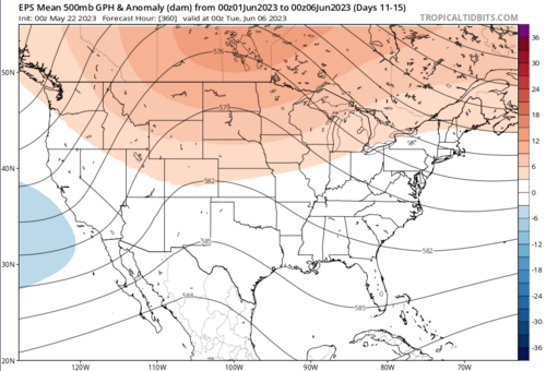
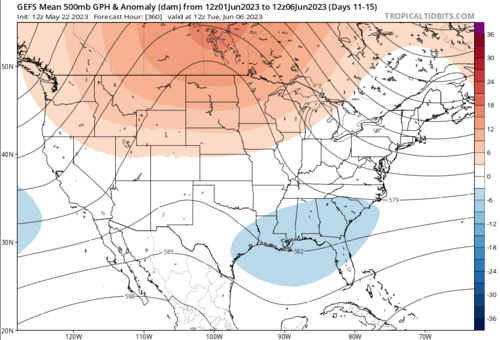
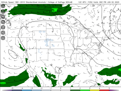
Unfortunately we seem to have arrived in about the exact same place we have seen in several of the Mays of recent past. Synoptic scale flow has subsided in the classic Plains chasing areas, and many neighboring areas as well. And it doesn't appear that things will pick up anytime soon, as recent medium-range forecasts suggest.

Screenshot 2023-05-22 at 15-32-41 EPS Model.png
Screenshot 2023-05-22 at 15-32-16 GEFS Model.png
Screenshot 2023-05-22 at 15-32-55 COD NEXLAB Numerical Models.png
(never good to see negative wind speed anomalies at 500 mb since wind speed can only go down to 0.)

Mesoscale-limited events are always possible, but predictability of those is quite low - you're unlikely to be able to confidently plan on a trip to the plains more than a day in advance.

As far as predictability goes, you'll probably need to start relying on HREF and the ML/AI/statistical products. Thankfully, more and more of those are coming online.

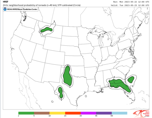
Take, for example, the 24-hour calibrated STP (circle) forecast based on the HREF:
Screenshot 2023-05-22 at 15-41-07 SPC HREF Ensemble Viewer - 24-hr STP-calibrated.png
It's only available for one day, though.

Nadocast is expanding its methods, though, so there are additional sources of forecast information:
http://data.nadocast.com/YYYYMM/YYYYMMDD (select a date from the root dir)
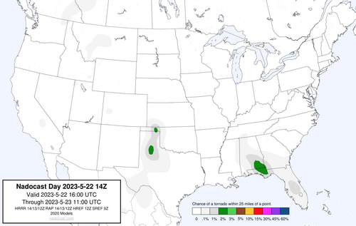
It looks like Brian is creating a new product at 0, 12, 14, and 18Z, but only tornado probs are available at the 14Z update. But he forecasts all hazards separately, so you can get some additional information that way. Here is today's 14Z tornado forecast, for example:
nadocast_2020_models_conus_tornado_20230522_t14z_f02-21.png
It appears the hail and wind probs actually go out two days, though.

Have fun! It's summah-summah-summertiiiiime.
 
Last edited:
Because my employer claimed I should have always had 10 hours instead of 8 deducted for each PTO day (I work 4 days/week, but they are NOT 10's!), I was short on PTO this spring and opted not to take a chasecation, as it would've meant foregoing my trip to Europe in September. I thought for sure as soon as I did that, this would be the year where all hell breaks loose on the plains again. Had I taken one, it likely would've been this week and next week. At this point it's looking like that was the right call, though! I can't believe the lack of any troughs on long-range models. I don't really know much about climatology, but... is the climate changing to the point where severe weather is becoming less likely? It seems like there have been several down years in a row now.
 
In a string of years filled with horrible chase patterns, this one probably takes the cake. It's looking very possible we may go through the entire peak climatological season without a single reasonable setup (or one cold-core setup if you want to include early May). That's pretty remarkable.
 
I'll just point out that it may be premature to count out June. The CFS has been pretty consistent over the past 6 or so runs that mid-June timeframe shows a distinct pattern shift to a more zonal to troughing/meridional flow across the plains Vs. this Chaotic Omega whacky cut off's. It's still way early sure, but... I just like the fact that its been fairly run to run consistent.
 
I'll just point out that it may be premature to count out June. The CFS has been pretty consistent over the past 6 or so runs that mid-June timeframe shows a distinct pattern shift to a more zonal to troughing/meridional flow across the plains Vs. this Chaotic Omega whacky cut off's. It's still way early sure, but... I just like the fact that its been fairly run to run consistent.

That could still disappear, though... Even if it verifies, it's small consolation to those who played the climatological odds and locked in their chase vacations during the more traditional peak... And particularly frustrating to me, after finally having the chance to spend more than two weeks out here, to see a dead pattern from May 22 all the way until June 15, when I really do have to finally get home...
 
That could still disappear, though... Even if it verifies, it's small consolation to those who played the climatological odds and locked in their chase vacations during the more traditional peak... And particularly frustrating to me, after finally having the chance to spend more than two weeks out here, to see a dead pattern from May 22 all the way until June 15, when I really do have to finally get home...

yeah I get it man, I cancelled my trip this week out there at the last minute in favor of Mid June. The interesting trend on CFS to watch is whether it will shift these changes to the right or left. so far, the changes have continued to show starting around 8 June.. with full effect by 15 June.. so that will be the thing to keep an eye on. if it shifts left any, you might get something out of it.
 
Last edited:
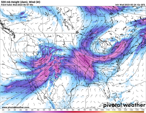
I know it's still in fantasy land, but GFS 12z just moved things around and brings flow to the plains around the second week of june. I was about to fly-in for the next couple of days and try my luck with the mesoscale low-chance setups as it looked like our only chance, but if it becomes a trend, it might as well convince me to be a little bit more patient.

1684953152558.png
 
Last edited:
yeah I get it man, I cancelled my trip this week out there at the last minute in favor of Mid June. The interesting trend on CFS to watch is whether it will shift these changes to the right or left. so far, the changes have continued to show starting around 8 June.. with full effect by 15 June.. so that will be the thing to keep an eye on. if it shifts left any, you might get something out of it.

The CFS has been flip-flopping a lot...which I suppose is to be expected at ultra-long range, but some consistency would be nice as it sure doesn't help with trying to book a time off period beyond Day 10.

For some reason the 06Z runs (like the one currently up on the CoD site as I make this post, which looks pretty good for the first full week of June) often seem to show a more severe-conducive pattern that tends to disappear on either the following 12Z or 18Z runs.

While the western Plains have been getting some drought relief, we are at risk of developing one here in the upper Midwest as we've seen little rain throughout most of May, and it looks like little to no chances even as far out as the end of next week/first few days of June.

Seems hard to believe given we just recently saw heavy upper Mississippi River flooding (record-setting in some places), which was driven almost entirely by northern snowpack melt rather than excessive rainfall.
 
Status
Not open for further replies.
Back
Top