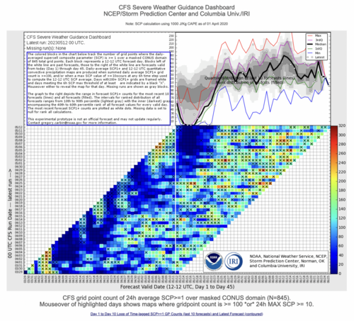
Things are just looking bleak for the next week and a half after today. There are signs that things could start to improve around day 10-11 or so but that western ridge seems pretty locked in until then.
-
While Stormtrack has discontinued its hosting of SpotterNetwork support on the forums, keep in mind that support for SpotterNetwork issues is available by emailing [email protected].
You are using an out of date browser. It may not display this or other websites correctly.
You should upgrade or use an alternative browser.
You should upgrade or use an alternative browser.
State of the Chase Season 2023
- Thread starter adlyons
- Start date
- Status
- Not open for further replies.
Warren Faidley
Supporter

Warren Faidley
Supporter
I'm going to start a new thread re: "Northwest Flow Events," since that seems to be the future of this season. Enjoy!
On Tues/the 9th, I saw my first 'lightning show' of the season (off in the distance, but still... Lightning!).
When it comes to storms fact is that a good thunderstorm/lightning show is my 1st love (never seen a tornado, so can't judge that. yet.)
There were multiple storms north/east of me that night, & I'm pretty sure I could see all of them to varying degrees, some were pretty far out there
There was one that fired up later than the others (and a bit closer, but still 30+ miles away) That one gave a pretty good 'show' considering the distance. Spent a half-hour sitting out watching it.
Then came Wednesday... Cloudy all day, but just sat there doing nothing til afternoon.
At work I stepped outside at lunch (to see how things were looking & if it was warm enough to eat outside(which it wasn't)), also had a look at radar & saw 'cells'/rain was beginning to pop up to the south.
A hour or so later I checked both outside(clouds were darkening) & radar, and noticed a warned storm to the south.
I obviously couldn't just sit there staring at radar and/or keep going out for a look. Another hour later I had a radar look & saw multiple storms had fired up, 3 being tornado warned (just radar indicated rotation in all cases)...including one that was headed straight for my neighborhood, which was within the warning. (that's not normal. we don't get tornadoes here. .lol.). The warning also stated half-dollar sized hail. .. .luckily said storm weakened before it passed over home.
Work also had a warned storm headed in that direction that afternoon but didn't end up within warnings.
After work, I had a good look at radar before heading home. There were tor-warned storms out east which I thought about, but rotation just didn't look very strong...and they contained large hail (I don't do hail). I decided against even attempting a chase.
(checked radar again when I got home & the warnings were gone)
The main thing with Wednesday is that the rain started that afternoon, then continued all night, and all day Thursday, and thurs night.
Finally some really good rain! (and I do love rain), this reminded me of the spring rains we'd get when I was younger!
Another chance for more rain tomorrow! but nothing like the previous system.
Maybe. Just maybe. The drought is done.
Warren Faidley
Supporter
Models have been trying to set-up a semi-classic west Texas sneak attack towards the end of the week.
Starting to see hints of SW flow returning around mid next week. Global models and ensembles generally agree that troughing will be returning to the west.
Warren Faidley
Supporter
Sticking with my earlier prediction of several, isolated sleeper events in the Southern Plains over the next week, starting later this week, featuring a cutoff trough out west and possibly underestimated upper level flow mixed with difficult to predict shortwaves moving up from the SW. The medium range models are very poor at handling these southern events so everything has to be evaluated day by day, especially when post-day boundaries are involved. Hopefully, the long shot, distant opportunities will keep the  circus away.
circus away.Jason N
EF5
That seems the case for what I am looking at as well. The disparity in solutions between GFS/CFS are pretty large beyond 200+ hrs (No major surprise there). I have been seeing a "slight" uptick in agreement for the Dakota's to Minnesota 27th -30th. This pattern that's emerging is pretty similar to my 2021 chase and I had pretty good luck there with minimal Circus/Hoard. If the CFS trends migrate to GFS, it could be pretty interesting up there, however, skepticism remains. The biggest issue I had that year was terrain and internet access gaps. but you can work around those issues for the most part. and if you can't, well your eyes do the work for you by staring at cloud structure lol.
Jeremy Perez
Supporter
This Saturday the 20th is when I can finally hop out of the AZ gate. I've been watching mainly GFES and run-to-run consistencies/variations with GFS. It's had me thinking more seriously about the need to hone skill picking out shortwave options and applying that inside the subtler flow over Texas near term. Current state of GEFS getting a trough to escape the Pacific NW and pull moisture beneath some decent flow after the weekend looks somewhat pessimistic for first part of the week. I really wouldn't mind getting up into Montana for good reason this season, where the jet seems it may want to hide out, but even with benefit of high plains elevation, moisture advection doesn't seem enthusiastic & really makes it feel like a stretchy/sketchy option. So for now, trying to get better at picking out sw nuances over boundaries & decent instability is where Plan A continues to land.
Jason N
EF5
What I saw up in Far eastern MT to central ND/SD, was "sort of" similar to that of further south dryline interactions over Western NE/KS except for the most part the DL was not sharp, distinct, but not sharp which slowed the moistening process down immensely. However, despite lower overall RH values and higher LCL's, if the hodograph shape was right, and correlating shear/exhaust/entrainment dynamics were in good alignment, the chance for longer duration LP made it worth it to me. What I also noticed was that sometimes the micro-climates around storm structures that would form off of dissipating cells outflows, or when there was a constructive merger, there would at least appear to "locally" be a drop in the respective LCL's, provided that the storms motion wasn't too fast, and that the overall downstream environment was similar or more favorable with the overall moisture plume shape/alignment. The bottom line from the few times I've chased in that area was, that things just didn't seem to translate as fast IVO the LCL. the Lapse rates are almost always huge, so the mid-levels were always pumping with crisp cloud edges, and there's plenty to stare at and have a great time.
Jason N
EF5
I also want to say, and I am NOT totally sure on this because it's been a while since I have gone and looked, but I thought I remember reading a paper that discussed HP Vs. LP distribution across the U.S.? (please correct me if I am wrong).
JF Massicotte
EF3
Sticking with my earlier prediction of several, isolated sleeper events in the Southern Plains over the next week, starting later this week, featuring a cutoff trough out west and possibly underestimated upper level flow mixed with difficult to predict shortwaves moving up from the SW. The medium range models are very poor at handling these southern events so everything has to be evaluated day by day, especially when post-day boundaries are involved. Hopefully, the long shot, distant opportunities will keep the
Looks like we are getting into what I like to call mesoscale season where synoptically evident events are rare but one can find decent day-to-day chase opportunities, some of which featuring high reward storms.
Jason N
EF5
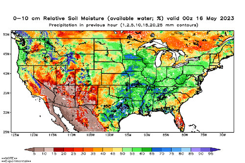
@Jeff Duda : I forgot your source for the soil moisture content. Could you post an updated one compared to the last one you posted? Just curious what a month or so of some additional rain has done.
Warren Faidley
Supporter
Attachments
When the SPC day 4-8 outlook says “potential too low” for the entire time period, that’s not a good sign.
Looking at the 500mb pattern I think we’ll have a bunch of marginal risk days this weekend into early next week. Maybe a slight or two. Moisture looks to be good enough but the flow is just too weak for any large-scale events.
Looking at the 500mb pattern I think we’ll have a bunch of marginal risk days this weekend into early next week. Maybe a slight or two. Moisture looks to be good enough but the flow is just too weak for any large-scale events.
- Status
- Not open for further replies.
Similar threads
- Replies
- 74
- Views
- 9K
- Replies
- 8
- Views
- 2K
- Replies
- 59
- Views
- 10K
- Replies
- 250
- Views
- 45K