• After witnessing the continued decrease of involvement in the SpotterNetwork staff in serving SN members with troubleshooting issues recently, I have unilaterally decided to terminate the relationship between SpotterNetwork's support and Stormtrack. I have witnessed multiple users unable to receive support weeks after initiating help threads on the forum. I find this lack of response from SpotterNetwork officials disappointing and a failure to hold up their end of the agreement that was made years ago, before I took over management of this site. In my opinion, having Stormtrack users sit and wait for so long to receive help on SpotterNetwork issues on the Stormtrack forums reflects poorly not only on SpotterNetwork, but on Stormtrack and (by association) me as well. Since the issue has not been satisfactorily addressed, I no longer wish for the Stormtrack forum to be associated with SpotterNetwork.

    I apologize to those who continue to have issues with the service and continue to see their issues left unaddressed. Please understand that the connection between ST and SN was put in place long before I had any say over it. But now that I am the "captain of this ship," it is within my right (nay, duty) to make adjustments as I see necessary. Ending this relationship is such an adjustment.

    For those who continue to need help, I recommend navigating a web browswer to SpotterNetwork's About page, and seeking the individuals listed on that page for all further inquiries about SpotterNetwork.

    From this moment forward, the SpotterNetwork sub-forum has been hidden/deleted and there will be no assurance that any SpotterNetwork issues brought up in any of Stormtrack's other sub-forums will be addressed. Do not rely on Stormtrack for help with SpotterNetwork issues.

    Sincerely, Jeff D.

State of the Chase Season 2025

Joined
Jan 14, 2011
Messages
3,429
Location
St. Louis
With March 1 now in view of 14-day models, I figured it would be a good time to start the thread for this year's chase season.

All operational and ensemble models into this period (GFS, Euro, CFS, GEFS, etc) are in decent agreement of artic air still remaining persistent in Canada despite a gradual (climatologically expected) warming in the middle latitudes. The 850mb temperature charts show that there is yet no end to the threat of winter weather, as this air could easily be pulled southward into the CONUS on the back side of any strong system. The somewhat good news for winter weather haters is that models also agree on a deep eastern troughing regime that shifts the artic air mainly into eastern Canada by March 1, taking the Plains and central US out of the crosshairs of any southward surge.

As for chasing, there isn't much of interest through the period. All models indicate some form of a northward Gulf moisture surge close to March 1, though this is shown occurring in that firmly-entrenched deep eastern troughing regime with a briefly-lived shortwave developing on the western flank of the trough before getting absorbed into it.

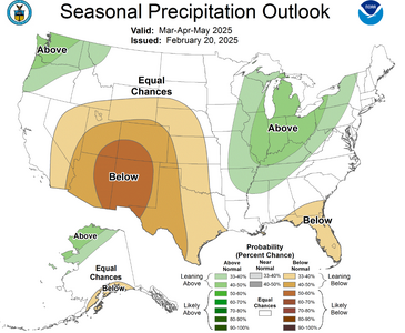
The CPC extended range outlooks also reflect the influence of this eastern troughing regime, with precip focused on the east coast and warmer temperatures in the west.

The drought monitor shows the Plains are in mostly decent shape, with extreme drought areas mostly focused close to the Rio Grande valley that may or may not affect the EML source regions.

All in all, it doesn't look like any end to winter is yet in sight. 850mb temps and surface dewpoints have been my go-tos for watching for a springtime surge, and there just isn't much to support that for as far out as can be remotely discerned.
 
Last edited:
The first week of March is within view of 14-day models. The same eastern troughing regime remains as was shown earlier, followed by what looks like an active jet near the Gulf coast with some form of moisture/MUCAPE shown making it northward into Texas/Louisiana.
 
All in all, it doesn't look like any end to winter is yet in sight.
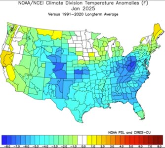
How true. January 2025 proved to be the coldest in 31 years in the contiguous 48 states.

Screenshot 2025-02-15 at 6.25.32 PM.jpg
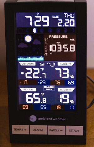
And this morning, btw, I had a low temperature of minus 23 degrees F beneath a 1035 + mb high here in Nebraska. _1000576.jpg
It appears reasonable that when spring makes a return, we'll see some truly dynamic systems. Hope too that moisture returns quickly if it gets scoured into the Gulf by the strong, cold-frontal passages. The current La Niña favors a greater frequency of EF2 through EF-5 storms for the mid-South centered around Tennessee, with a somewhat lesser enhancement towards and around Oklahoma, but still favorable.
Big question, when does this get going in the Southeast? How long will we wait for the Southern Low Plains to get active?
 
Last edited:
So much for the previous long-range forecasts for that persistent eastern trough. March is looking to start out quite active, with a some progressive troughs bringing a couple of supercell (and possibly tornado) days to the lower- and possibly mid- Mississippi valley regions next week. At the very least, prospects look good for some lightning outings possible as far north as the southern Great Lakes.
 
March, April, & May of 2025 have got some analog years based upon the EPO, PNA, and of course, ENSO.
I'm not the only one looking at these things, clearly, but among the years are 2006, as well as 1996 and 2009.
And while results can vary when making forecasts from forecasts, there's still some value to be gleaned from it.
Once again, get out in March and April if you can, even if the activity is biased southeast of traditional tornado alley.
Likely cold outbreaks with strong jets make for some fast-moving storms; getting your tornadoes sooner than later might prevent a lot of grumbling if the weeks in May don't cooperate. I'm remembering some frustrations during the last halves of May during some of those analogs.
Now, if I can take my own advice. 🤣

All three of those years were horrible
 
Any of those analog years would be welcome to Midwest chasers, but problematic for peak-season Plains chasers. 1996 had some classic days in central Illinois, the one on I-72 near Springfield was one of those that made appearances in late 90s tornado docs. May of 2009 had Kirksville, and June 8 brought a pretty nice supercell/tornado 10 miles from where I would eventually live in the STL metro less than a year later. 2006 of course had March 12 in MO/IL, a *huge* April in the mid-MS/TN valleys and the Crosstown F4 south of here. After last year, I could use a lower-mileage season like those.
 
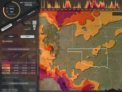
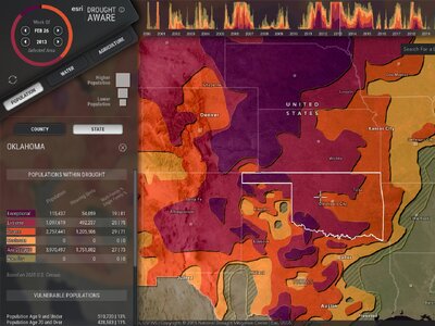
We have some reasons for optimism. A comparison of drought conditions between 2025 and 2013 shows we're doing better than a dozen years ago with moisture. I'm comparing these two years because...
Even though 2013 can be characterized as often slow, inconsistent, below average in many respects, we still had Moore, OK and El Reno, OK in the last half of May, even with drought issues in ENSO neutral.
Enlightened conjecture, informed speculation, I'm there, but it's like sports, you have to play the game. 2025 shown above and 2013 below.
Screenshot 2025-02-28 at 11.30.43 AM.jpeg


Screenshot 2025-02-28 at 11.29.51 AM.jpeg
 
In the somewhat shorter term, there is some potential for a significant severe weather event in the relatively favorable terrain of eastern Arkansas next Tuesday. Plenty of uncertainty this far out with timing, storm mode, intensity, etc., but if I were still living in the St. Louis area I would be watching this one quite closely. Time will tell. But if things shape up for afternoon severe in eastern Arkansas, there are a lot of areas with pretty decent chase terrain there.
 
I think this year will be an interesting one for me, mostly due to non-weather related things in my life. The Air Force recently moved me from Altus, OK to Colorado Springs, and so the starting point for the vast majority of my chases will be here, rather than in more traditional Plains chasing territory. I was just starting to get comfortable with my chase style and forecasting in the Southern Plains too! Differences in peak season, dynamics, road networks, etc. will certainly make for a fresh challenge chasing from out here.

Additionally, my new work schedule is 6 days on, 4 days off. While that does offer large chunks of time off, I am also changing shifts every one of those cycles, so I'll have to take into account swings in my sleep schedule when determining whether I'll chase on any given day. Many of my chases previously were on work days because I lived in the target area, so I rarely felt the need to take off work to chase because I had time after I got off. It remains to be seen whether changes to my work schedule and location will net me more or less chase days overall.

Finally, due to the current politics of the day (which I do NOT intend on discussing, but they are relevant in this case), I will likely lose my job as active duty Air Force soon. Now while that won't change the starting point of my chases, it could throw a significant wrench into the works as far as employment, finances, and schedule/time off. So that is a pretty big wild card. Overall, after having a career chase season last year (saw 5 tornadoes total on 11 chase days, including my first supercellular tornado) I am really looking forward to this year and the new challenges it will provide.
 
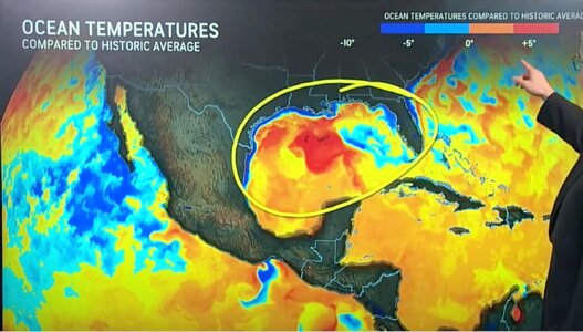
Interesting to see the cool spot in the northeastern Gulf though. I wonder if we are seeing that impact this upcoming system; on nearly all of the model runs, despite vigorous initial northward moisture transport into Texas and perhaps even well into Oklahoma starting tomorrow morning, the warm sector seems to have great difficulty expanding eastward Tuesday afternoon and instead gets increasingly pinched off with time. This is likely why we've seen SPC back off a bit (after introducing "strong tornado" wording at Day 6 range on Thursday, the Day 3 outlook issued today doesn't even include an all-hazards hatched area).
 
Even though 2013 can be characterized as often slow, inconsistent, below average in many respects, we still had Moore, OK and El Reno, OK in the last half of May, even with drought issues in ENSO neutral.

2013 is such an enigma. You are correct about how the season is generally characterized. But that last two weeks of May - the exact peak time that any chase vacationer would choose if able - was absolutely incredible. I recall there being chase opportunities just about every single day during that stretch, including memorable high-end days such as Rozel, Shawnee, Moore and El Reno. While other years are generally seen as good chase seasons just because of one or two memorable events, somehow 2013 is still seen as sub-par.

As for me personally, 2013 was memorable because of its level of failure and is still painful to recall. My trip exactly overlapped the active period, but I screwed up every single day, with a different fail mode each time. Trying to redeem myself near the end of my trip, my final chase day ended by getting stuck in a drainage ditch on a muddy road. The shame-fest ended when I decided to go home as scheduled on May 31, when I could have extended a day for El Reno; this regrettable decision was in part driven precisely by the frustration of the preceding two weeks, believing I would only continue to have bad luck. For a year, I made my iPhone wallpaper a picture my chase partner took of me with my head bowed, walking away from our vehicle stranded in the mud (similar to Eagles quarterback Jalen Hurts putting a picture of his 2023 Super Bowl loss on his lock screen).

All of which is to say, if 2025, or any future season, is like 2013, I would be extraordinarily pleased, even though my remote work situation means I don’t necessarily have to depend on picking just the one right two-week stretch anymore…
 
I think one thing is clear, that this season will not be a repeat of 2024. It seems that with an expected ENSO Neutral through spring, and analogues of past occurrences, that we will have to see how the storm track/500Hpa patterns setup. I think the moisture/EML parameters based on drought and SST's seems to say for now at least that those won't be driving negative factors. It seems more likely that the AO/NAO/PNA locations per ENSO Neutral phase combined with the MJO phase setting up Ridge/Trough locations might be the dominant positive or negative issues across MAM and MJJ. if the CPC 3 month outlook is any indication for heights and precip, albeit low resolution, this year could be more chasing in areas that don't have the best road networks of views with forest cover outside of farmed areas. NW flow events again? with transient lower and upper plains days across May/June.

I wonder if this year will look like 2020 just looking at Past ENSO data, with a more active March/Apr in the South and SE. then a Weak May/Jun in the plains with no real clear hot spots.

1741017146503.png
 
I wonder if this year will look like 2020.
Much of your post seems reasonable, logical. :) But, I'm not sure I'd go down the 2020 route with that year as an ENSO analogue.
Reasons for that include using ENSO's prior months' influence (a.k.a. the lag) as well as the direction & magnitude of the change of phase, if any.
One can visualize scenarios where the eastern halves of OK & KS are more active than the western portions. Looking forward to getting out, too.
 
Last edited:
Back
Top