• After witnessing the continued decrease of involvement in the SpotterNetwork staff in serving SN members with troubleshooting issues recently, I have unilaterally decided to terminate the relationship between SpotterNetwork's support and Stormtrack. I have witnessed multiple users unable to receive support weeks after initiating help threads on the forum. I find this lack of response from SpotterNetwork officials disappointing and a failure to hold up their end of the agreement that was made years ago, before I took over management of this site. In my opinion, having Stormtrack users sit and wait for so long to receive help on SpotterNetwork issues on the Stormtrack forums reflects poorly not only on SpotterNetwork, but on Stormtrack and (by association) me as well. Since the issue has not been satisfactorily addressed, I no longer wish for the Stormtrack forum to be associated with SpotterNetwork.

    I apologize to those who continue to have issues with the service and continue to see their issues left unaddressed. Please understand that the connection between ST and SN was put in place long before I had any say over it. But now that I am the "captain of this ship," it is within my right (nay, duty) to make adjustments as I see necessary. Ending this relationship is such an adjustment.

    For those who continue to need help, I recommend navigating a web browswer to SpotterNetwork's About page, and seeking the individuals listed on that page for all further inquiries about SpotterNetwork.

    From this moment forward, the SpotterNetwork sub-forum has been hidden/deleted and there will be no assurance that any SpotterNetwork issues brought up in any of Stormtrack's other sub-forums will be addressed. Do not rely on Stormtrack for help with SpotterNetwork issues.

    Sincerely, Jeff D.

State of the Chase Season 2025

Much of your post seems reasonable, logical. :) But, I'm not sure I'd go down the 2020 route with that year as an ENSO analogue.
Reasons for that include using ENSO's prior months' influence (a.k.a. the lag) as well as the direction & magnitude of the change of phase, if any.
One can visualize scenarios where the eastern halves of OK & KS are more active than the western portions. Looking forward to getting out, too.
oh yeah!. I certainly hope I didn't come off as trying to sell it as fact, it's why I said, I wonder lol. I was just panning across the historical and looking for some similarities, and I thought 2020 seemed like a "loose" comparison, but you're not wrong, lag time and all that. I just don't want to see what happened for a few years where transition to a summer-time ridge happened well before it was supposed to. That said, Im going out twice this year, End of May, Middle of June, so I'll just remain hopeful for a good upper-level pattern or at worst case, some sub synoptic pattern for boom or bust scenarios lol.
 
I just don't want to see what happened for a few years...
2020...striking fear & panic into the hearts & minds of chasers everywhere... for all the wrong reasons. 🤣
I made my iPhone wallpaper a picture my chase partner took of me with my head bowed...
I found a nice, peaceful video for you James and posted it below. :)
 
Time to get serious next week / weekend for some chasers? Too early for an event post, but large trough moves onshore Thursday, then strong, lee-side, surface-low in CO developing Friday, but big spread on track, timing, precipitation type and mode this far out. For ex., Omaha mentions possible snow band, to a shot at severe weather, to maybe dry slotted w/ no precip. It will be a highly-amplified, brute of a system regardless, w/ strong wind fields expected, but a difference this time appears to be better moisture getting pulled up, with 60s dew points in AR and 50s for MO.
 
Last edited:
With the time change this weekend my season begins. Yes Saturday March 15 catches my attention. Could be a Mid-South and surrounding areas days. Or, the system lumbers out in two pieces and all we get is heavy rain.

At any rate I will chase Dixie. No more snobby, I live here and even I don't chase the South. While 2024 rewarded patience, waiting for the Plains has not paid off most recent years. Chase early! Chase often!
 
it won't be long before Jeff D comes in and says, this line of discussion should be talked about in Target Area weather lol... 😆

personal opinion: I'm just not a fan of Dixie chases at all. minus a few miles of good open terrain in MS. and some here and there in AL. Road networks, towns, more red lights and people, it's the same kind of chasing as in the Carolinas, it just takes a lot of the "fun" (meaning purity with lower risk, higher enjoyment) out of it. The other side of information sharing and observation for more warning safety by helping people, I'm with it!.

14/15 Mar: at this moment where the models are MO/IA/MN with low topped SC with closed 500mb TOR risk, and then down TN/MS/AL for the better moisture fields, but the hodo's Shear looks ample, so like you said Jeff H, training heavy rain maybe as well with embedded QLCS/LEWP spin ups seems possible. ( another reason I dont like chasing Dixie most of the time. discreet cells dont seem to happen as often.. its all waiting in heavy rain for the QLCS or maybe just out ahead of the main line a quick cell to pop which makes chasing down a embedded spin up inside of a line annoying ( to me anyway ).
 
Quite the March wave train we're in. Friday and/or Saturday will definitely deserve a thread once it becomes clear which one is the primary day, hopefully in the next day or 2. It could be that both days will. Everything seems to hinge on how fast the influence of the preceding trough can clear out and allow moisture to surge north. We've seen plenty of these turn out to be nothingburgers though (including this last one), even these blockbusters have plenty of failure modes.
 
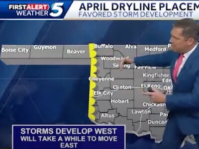
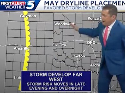
BTW, OK & TX Panhandle chasers, OKC's KOCO 5 has made an interesting prediction for a month or two ahead. First, next month 2025...
1.jpeg
Then the "big" month 2025...
1 (1).jpeg
I imagine they're "seeing" good moisture & favorable trajectories from the Gulf to predict these. At least they don't set up the dry line over OKC !
 
Last edited:
...in the Mid South and Deep South
Jeff, you've got something to look forward to, particularly with this system Friday, as you probably know!
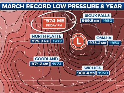
Regarding this anomalously deep cyclone & very strong surface-system ahead, EAX mentions that NAEFS continues to indicate good probabilities of a couple records or near-record lows: H5 heights and MSLP, both relative to early & mid March numbers.
Wrap-around blizzard aspect of these early-spring systems, that's fine, but as I alluded to a couple days ago, the severe potential's exciting.
 
I didn't set a low-pressure record here, but it was a wild Friday & Saturday, March 14-15, in the Midwest & Southeast as expected.

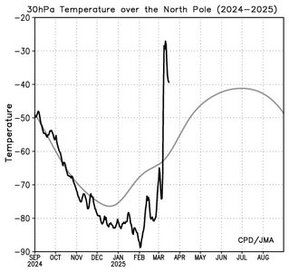
The news now, the stratospheric warming peaked ~ 10 days ago, and you can see the trend below at 30 mb, as well as on 10mb charts.

Image A.jpg

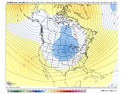
There's a time lag, but this will force the troposphere into anomalously low heights in the North-Central region over the next month.
B.jpg

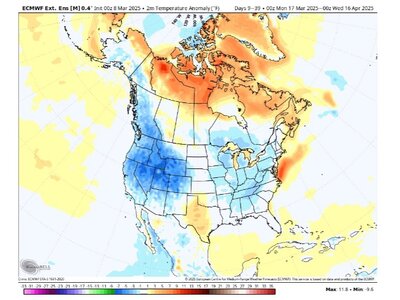
This in turn will keep cold incursions arriving with temperatures below normal in many locations through Mid-April and perhaps beyond.
Image C.jpg
This will give chasers a bit of a "breather" and might provide hope for those individuals holding off until a bit later in the season.
 
I agree with the extended forecast risks. Therefore I suggest making the best of Wednesday even though it's just Slight attm. Moisture will be a challenge. It's a bit veered off. However visibility will probably be better for whatever happens on Wed.

Sunday was a head scratcher until the 12Z Euro came out (Monday). Looks more robust for the Deep South and even Mid-South. Probably good to watch both those days. Indeed a lull in the action may be coming next week.
 
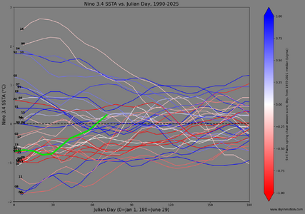
I haven't done a deep dive or any serious digging into a wide array of climate signals, but figured I'd post an updated version of my annual Nino 3.4 SSTA timeseries. These use weekly data and show essentially the first half of each year from 1990-present. Years with springs that scored as "good" Plains chase seasons in my reports-based calculation are more blue, while years with "bad" Plains seasons are more red. This year is bold and green.

weekly_all.png

My early expectation last summer looking ahead to 2025 was for a season falling somewhere between average and nightmarish, since we're exiting El Nino and failing to swing immediately into a strong La Nina (ala 2008 or 2011, where big synoptic systems can be prevalent and help compensate for drought). I haven't seen anything so far to sway that expectation. As shown on the plot, recent years that start out as very weak Nina or the cool side of neutral in winter are practically a graveyard for Plains chasing. What's interesting is that 2023 finally broke the mold and now stands out as the lone blue line that starts out between 0 C and -1 C in January. However, as we now know, 2023 transitioned very rapidly into the early stages of a strong Nino by summer/fall; IMO we began feeling the "wet" effects of that by mid-late spring on the Plains, and that helped make it a good season. There's absolutely no indication from statistical or dynamical models that another strong Nino episode is forthcoming later this year, let alone one that starts so anomalously early. Still, it's interesting that our SSTAs are now notably warmer than the great majority of the graveyard years (2018, 2014, 2012, 2009, 2006, ...). The closest match to our progression thus far is 2023, even though we know that trajectory is likely to diverge over the coming months, with 2025 staying more neutral or perhaps even cooling again.

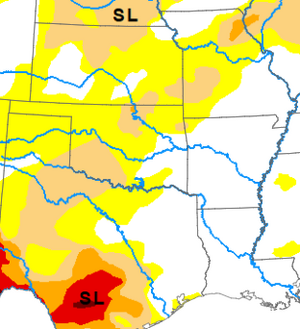
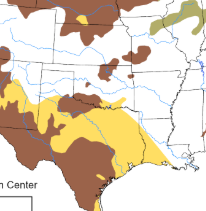
For what little it's worth, I still expect this to be a somewhat frustrating, drought-plagued spring with at least some characteristics of seasons like 2018, 2009, etc. It seems the more comprehensive attempts at seasonal forecasts I've seen thus far (e.g., Convective Chronicles) are also bearish. It would be very surprising if we see anywhere near the consistency of the past two seasons, but that doesn't mean you can't sneak in a short period or two that's highly productive (see late May 2013, or mid June 2014) to help lift the season far above the real nightmares like 2006 and 2020.
 
It seems the more comprehensive attempts at seasonal forecasts I've seen thus far (e.g., Convective Chronicles) are also bearish.

Just watched the Convective Chronicles forecast yesterday (and have been depressed ever since 😕) Trey Greenwood based his forecast on ENSO, drought conditions, and Gulf SSTs (which are warmer than average). He forecasts an average April, below-average May (with the unfortunate qualifier “quiet Plains”), average June, and a slightly-below-average overall season. Only three of Trey’s analog years are within my chasing career - in order of correlation, 1996, 2006 and 2018 (2018 being last on his full list) - all of which I recall being horrible. Not quite evident from the simple deviations from average is that some of the analog years had a notable dearth of tornados in large swaths of traditional chase regions.

 
Back
Top