State of the Chase Season 2024

Status
Not open for further replies.
2024 has been a solid year so far. I do agree there have been a ridiculous amount of wasted systems since mid March, and had just one or two more of those reached their ceiling, then 2024 would be in elite tier status already. Still, 4/26 was a banger of a trimodal outbreak, the best in over a decade, which admittedly isn't saying much. Regardless, that day was a career day for a lot of chasers. The recent stretch of 10 out of 12 days in a row producing tornadoes (4/25-5/6) is one of the greatest runs of tornado activity in the southern and central plains we have ever seen.

The upcoming pattern shift back to a more favorable severe weather regime will have a significant impact on how 2024 is ultimately perceived in the chase world. If we get a run that rivals late May 2016 or 2019 or dare I say 2013, then 2024 will undoubtedly be talked about among the greatest years ever, even if June were to be mostly a dud. Now if the opposite happens, say we end up with a lackluster end of May with grungy storms and June is a dud, then 2024 will fall among the mid tier of seasons with a strong mid-spring and not much else. I guess we will find out in the next few weeks. Safe travels and good luck out there. See you under the meso.
 
Back to the discussion about the upcoming pattern change, besides Sunday (see that EVENT thread) it still looks like about a week to 10 days of on-and-off setups in the Plains where SW mid-upper flow and good moisture will be present and in the late May period that is all I look for for chasing. Beyond that ensembles and weeklies suggest central and southern Rockies ridging, we shall see.
 
So let's try to put things in perspective going by raw stats and historical comparison...

April tornado total currently is 325 (actual tornadoes). This is the second most on record for April and only the 20th month to have 300 or more U.S. tornadoes. This number is still going up as more reports and data come in and are examined, and will until the end of July when the final Storm Data is submitted from all WFOs to NCEI.

May tornado total is currently 215 through the 16th. This is well above average for the month so far, and given that pattern setting up for the next week, we are likely going to add a lot more to this total, and likely eclipse 300 tornadoes before the month is over. If 300 is reached, this will be only the second time the U.S. has had 300+ tornadoes in two consecutive months and two months in any year (the other year being 2010 - May/June).

680 tornadoes have occurred in the U.S. so far 2024 through 5/16. This is well above average. Yes, prior to 4/26, there was a dearth of tornadoes in the Plains, but 40 already in IL -- not exactly bad storm chase country. And since 4/26, things have "corrected" with many, many highly visible tornadoes in traditional tornado alley!

So it is unclear why there are still complaints or negatives about tornadoes from a storm chasing POV this year. This has been one of the better seasons so far IMHO both from a meteorological stat and successful tornado intercept angle, with some of the most amazing videos and photos we have seen.

Additional stats:

Most tornadoes in two consecutive months:
1) 1084 April/May 2011
2) 835 May/June 2003
3) 777 May/June 2004
4) 754 May/June 2008


Monthly U.S. tornado counts 300 or more:
April 2011 758 June 1990 329
May 2003 543 May 1982 329
May 2019 510 May 2011 326
May 2004 509 April 2024 325*
May 2008 462 June 2010 324
June 1992 399 June 2005 316
May 1995 391 June 1993 313
May 2015 381 May 1999 311
June 1998 376 May 1998 310
May 1991 336 May 2010 304
 
Despite the incredibly high number of tornadoes and the epic 4/26 chase day, I can't shake the feeling that this year has underperformed slightly so far. Like Brett said, there have been several excellent looking setups that have busted and the chaseability of many of them were poor with the exception of a few days within the end of April and first couple days of May. My location has me prefer the Central Plains area, so take that for what it's worth, but I've chased five days so far with one being incredible, and the other four largely busts (I've only taken my camera out on one of those four days).

Looking forward, it appears that any moisture will be swept out of the central US by several cold fronts after Tuesday through roughly the end of May. So that's not great. Largely wastes over a week of southwest flow, though there will probably be an opportunity or two south of the OK-KS border this weekend. After that the upper air pattern looks like it changes to more prominent western and central US ridging, so it might be a while before our next real opportunity.
 
Agree the weekend will offer chances. Right now computer models have upper level waves timed about as poorly as possible. However it's days 5-8 so not a huge concern. Southwest flow is in place. Return of moisture far enough west seems to be the only other issue. That'd resolve if upper level wave timing improves. It's all related.

Biggest concern is that the moisture remains south of I-70 and doesn't get back to the Panhandles. A sagging boundary would focus moisture in the most chaser congested area of the Plains. We need some changes in the mid-range forecast.

After the end of May pause, attention shifts to the High Plains and Northern Plains a few days into June. That would probably be just about it for the heart of the central Plains. Chase season will roll on where one would expect it to do so in June.
 
Despite ample moisture and modest to moderate flow over OK/TX for most of the next 5-7 days, it does look like "a mis-timed shortwave a day keeps the chasers away" for at least the first part of that period. It's late May and moisture in the warm sector should be seasonably rich (at least before convective overturning), so it's unlikely we make it through Sat-Sun without a couple decent tornadic storms, even if their predictability and targetability is poor. And there's still certainly a chance for one or two more substantial chase days to materialize in the Thu-Sun time frame, but it looks likely that they'd be in the general I-35 corridor of OK/TX (maybe NW TX if we're lucky), which is relatively disappointing this late in the season.

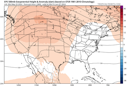
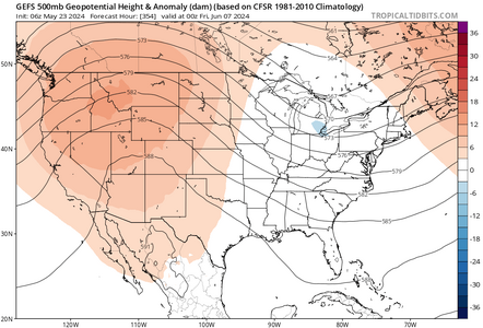
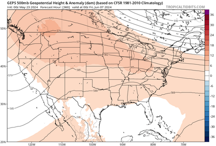
Afterwards, it's hard to find any signal other than doom and gloom beyond this weekend. New ECMWF weeklies today show continuous Rockies ridging and eastern troughing throughout June, as usual. The endless sloshing dryline and/or SW flow upslope days of 2004, 2008, 2010, or that one glorious week in 2016 -- where you'd jump between cheap rooms in Dodge, Salina, and Kearney for high CAPE setups that had real potential -- seem like archeological history at this point. I respect the perseverance of the Northern Plains contingent that hasn't drifted out of the hobby entirely. But at least the season has been better than many recent years already, especially if you ignore geographical preferences within the Alley, predictability, and a preference for the late season's sunset times.
 
I respect the perseverance of the Northern Plains contingent that hasn't drifted out of the hobby entirely.
Thankfully I have several other hobbies (and work) to keep me busy, otherwise I probably would have called it quits a while ago given the pitiful last 5-6 years. Or 12 years if you want to isolate it to the northern plains.
 
I like the northern Plains, in a big part because the hordes have become unmanageable farther south. After that stretch is over, I am hoping to go up there sometime in June.
 
All long range ensemble guidance looks pretty bleak starting about 2 weeks from now. Right in line for the start of my vacation from the 8th to the 15th. I guess the good thing about June is that unless you have the worst death ridge pattern imaginable, you can still get some pretty supercells on the high plains most days.IMG_0919.pngIMG_0920.pngIMG_0921.png
 
This week is off to a bang. Sunday was a classic Oklahoma dryline day, followed by a high plains chase on Monday, then another historic tornado day in Iowa, followed with tornadoes deep in the heart of Texas yesterday. Today is another classic Oklahoma dryline day (sadly I can't chase), followed by a potent setup Saturday, then further east on Sunday. I find it kinda silly to be talking down on 2024 at this point. I haven't had anywhere as productive of a year as I was hoping (blasted life responsibilities keep coming up), but still plenty of opportunity ahead. It does appear things may quiet down some next week, but I suspect there are more mesoscale days coming that models don't resolve well at this range.
 
Last edited:
2024 in the Plains is perhaps best summarized by a phrase someone posted on the Discord just as $@#! was about to hit the fan in Texas, then Oklahoma, then Arkansas yesterday evening:

"Night wedges incoming."

Tough year. Perhaps more high-ceiling setups than we've seen in several years; but nearly all significant tornadoes with them occurred after dark (4/27, 5/6, 5/25) and/or were fast-moving and hit populated areas (4/26, 5/21). Edit: @Brett Roberts summed it up pretty well in his Reports post for yesterday.

We did at least have a few relatively lower-key risk days that produced somewhat slower-moving, photogenic daylight tornadoes, at the start of May and again late last week.
 
Last edited:
I pity anyone who booked a June chase tour. The dreaded "death ridge" looks to be upon us. Get your passports ready.
It’s me, hi 👋🏻 I have a tour booked for the second week of June. Looking at the long range data is…well, not fun right now, to say the least. I’m banking on some NW flow events or rogue shortwaves to save the day because troughing in the west is most likely not happening for my tour. Today’s 12z GFS actually doesn’t look half bad given the recent guidance showing crapola, but I need to see a lot more than one long range GFS run before I start feeling better about that week.
 
Status
Not open for further replies.
Back
Top