State of the Chase Season 2024

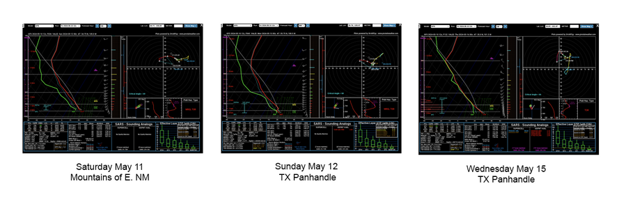
Looking like some very long shot, isolated sneak attack potential for the Saturday+ time frame. Not going to analyze the individual soundings on merit, as they are cherry picked and have obvious negative factors besides initiation and isolation that would keep most sensible chasers from pursuing, unless you just "happened to be in the area." However, they do illustrate the "potential" when factoring 40kts of 500mb flow and DP's >50 ºF. in this region.outbreak.png
 
I didn’t look at Saturday 5/11 or Sunday 5/12 because I can’t be out there anyway, but this morning I did notice some potential for Wednesday 5/15 and also Sunday 5/19 on the Euro. I didn’t go any deeper than a big-picture look at moisture and 500mb flow. Still leaning toward delaying my trip, not sure Wednesday is worth heading out for.

Sunday 5/19 will be a more difficult decision, because I am planning to start my trip then no matter how it looks. That is when my son is able to start his trip; he can’t leave before then because he has to work on Saturday night. If I was already out there, he would fly out to meet me. If I’m not already out there, is Sunday good enough to justify heading out on Saturday without him, and then facing the logistical challenge of having to pick him up at an airport on Monday? Yes, I would have to deal with that anyway if I was out there already. But if I’m not, then I might as well wait just one more day so we can fly out together.

I’ll see how the model scenarios evolve throughout the week. If Sunday looks *really* good, it will be an easier decision to head out on Saturday. Who knows, I may even decide to fly out Tuesday night for Wednesday if Wednesday improves enough.
 
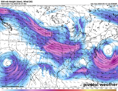
This Wednesday 5/15 seems to have some potential in the Fort Stockton area - just looking "big picture" at only moisture and 500mb flow. Next Sunday the 19th no longer looks like anything, but as Andy said Monday the 20th has promise. The Euro shows areas of interest in E CO and the TX PH. GFS agrees on E CO but not the TX PH. I'm not looking beyond that - that's the end of the Euro run, no sense looking at the GFS beyond 10 days (or even within 10 days! 😏)

I don't know how Wednesday will turn out, but I am prepared to write it off and just start my trip a week later than originally planned. It's not worth flying out for Wednesday and then having basically nothing Thursday through Sunday. Also Fort Stockton is one of the most inconvenient places to end up. I'm glad Sunday the 19th appears to be off the table, this way I can just fly out with my son that day to set up for Monday.
 
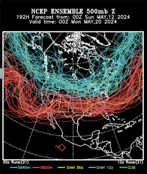
GEFS ensembles still show a slight bias toward western troughing (or at least zonal flow) beginning on the 20th with corresponding daily SCP spikes, though the individual members are all over the place (per the spaghetti plots). The Euro shows a compact shortwave trying to eject over the Plains around that time, but it's been slowing it down and plotting northerly flow over the Gulf ahead of it.

The upside is there's no death ridge or mega-eastern trough showing up (yet). 30kt+ zonal flow works, as long as we have moisture.
 
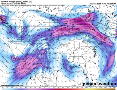
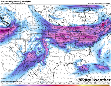
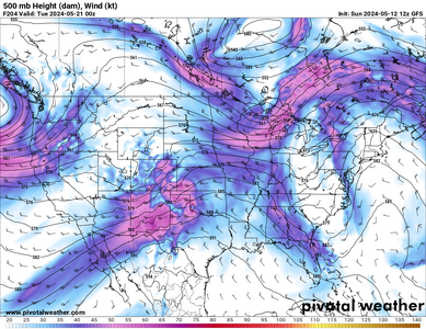
At this point I am flying out on Sun 5/19 no matter what. My main concern is if Mon 5/20 is a chase day, and if so, where. The flip in the models is maddening. Look at each of these depictions for 7pm CDT on Mon 5/20. Yesterday evening's runs of the Euro and GFS were somewhat aligned:

Euro 0z Sun.pngGFS 0z Sun.png

But with the 12Z run this morning, the Euro flipped and looks terrible.

GFS 12z Sun.pngEuro 12z Sun.png
 
May 20-May 31:

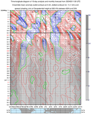
Some of the AI versions of the NWP models have a Northern Rockies trough with ridging east of the Mississippi River. A possible jet extension and pull-back could happen, per Asia and North America pressure trends, but I'm not enthusiastic about such a bullish scenario.

I see some MJO hype on Xitter, but the satellite photos are not talking to me. Indian Ocean to West Pac. looks muddled to me. Plus those MJO standing wave forecasts are notoriously unreliable. Standard ensembles (EPS GEFS) are meh.

Weekly products ECMWF and CFS may provide a more reasonable middle ground. No classic Rockies trough East ridge, but they show good flow through the Heartland. Texas ridging could cause warm mid-levels. Farther north precip. anomalies are positive.

State of the season (late May) I will say ticked up over the weekend.
 
As we ride out this mid-season lull, I have to say paradoxically that 2024's early season was simultaneously above-average in quality and yet also the most disappointing I've seen in 19 years of chasing.

The number of "wasted troughs" over the past 6 weeks that were in the textbook, synoptically evident realm was simply staggering. It had to be something like 6-8 such troughs that kicked out over the Plains between March 24-May 6 but were either slightly mis-timed, had Gulf moisture swept out three days beforehand, had an inexplicable blob of 30s dews appear along the dryline at 18z... on and on and on.

The only caveat is that one of the most impressive such troughs did produce the April 26 E NE/W IA outbreak, which is arguably the most impressive the Plains have seen in 12 years. I'm not going to diminish the significance of that event: it offered the most storms with highly visible strong daytime tornadoes in many years, with the potential for a career chase day if you played it well. But that sequence still pretty much blanked the core of the traditional Plains alley, with big daytime busts the day before and after that in KS/OK/TX.

It goes without saying that March-April are known for big troughs that fail to produce major outbreaks due to the innate scarcity of moisture early in the spring. But I still can't get over how many quality troughs came our way the past couple months. We've gone years without seeing more than a few of those trough ejections at any time during spring, and the way things have gone the past decade, we probably will again now.
 
GEFS ensemble members are starting to cluster on WSW flow between May 20-24 with signals for precip in the Plains (breakable cap). The operational GFS concurs. There is still considerable spread thereafter. Euro is moving a shortwave in a little to far south for my liking, but there is moisture, CAPE and lightning density activity showing up from the Plains through the Midwest during that time.
 
I'll decide next Monday if I am heading out or postponing until mid-June, (my next available Window from work). I saw kind of the same thing as you Dan, and it looks like if that holds the 5 wave and 85 moisture may be in a bad phase for the 24 to 1 June timeframe I am looking at.
 
I am a bit flummoxed as to the overall sentiment regarding the season so far both here and on social media. The 16-day stretch we just saw in late April and early May was one of the most active such periods on record and included several photogenic tornadoes in multiple states from multiple storm systems. There were opportunities for everyone who was willing or able to get out there. In fact, I can't remember such a favorable period during the start of peak season in the Plains or Midwest since 2019 - and before that you're probably going back much further to find a comparison. The dilution of such an impressive stretch across the storm chasing community is confusing to me and makes me wonder if folks are simply just judging the season based on their own ability (or inability) to chase these events. Anyway...

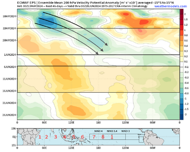
The hemispheric pattern coming up in late May is quite favorable once again and has been strongly signaled by subseasonal forecasts since February. Analog data and long-range guidance has done a great job this year as we proceed through a Terminating El Niño regime. Historical data strongly points to the heightened potential for tornado outbreaks during this regimes particularly when La Niña conditions have not yet developed in ENSO 3.4 by June 1 (this year). We're also getting additional help from periodic MJO propagations. This upcoming stretch in late May will be no different. A prolonged -AAM regime has also helped to contribute to a favorably oriented Pacific Jet and oscillating N Pacific ridging.

eps_chi200_anomaly_hov_equatorial_2024051300_MEAN.png

It's still TBD how this will play out in terms of details or specifics (mesoscale forecasting be damned at this range), but the global ensemble solutions depicting several days of southwest or westerly flow juxtaposed with ample instability and moisture are not a coincidence. This period should offer the opportunity for a favorable synoptic weather pattern across the Plains in late May for the first time in several years. Thereafter, the pattern tends to begin to look less favorable to me by mid-June with a more standing-wave look and lots of subsidence being signaled from the Indian Ocean towards the dateline and convection over the Americas. My opinion is to get out there starting 5/20 and chase what ensues.

Enjoy the chasing and the upcoming peak season, y'all.

Hope to see you out there.

J
 
Regarding the season thus far, I would have to agree with Brett more than John in the posts above. Yes, it definitely has been above average in terms of numbers of tornadoes and numbers of promising setups. But aside from April 26th, and a few back-to-back days in central TX that I get the sense not a lot of chasers went after (though some smart ones did), most of the tornadoes were after dark, hard to see due to low clouds and rain, and/or in poor terrain. So despite the large number of tornadoes, I think it has been somewhat disappointing in terms of chasing, except probably for people who chased the aforementioned events. But like Brett said, there were many promising-looking setups in prime chase territory that just did not work out.

All that said, we are just now getting into peak chase season, there are signs of the current pattern changing, and there will be lots of opportunities, including a lot of time in late May and June that is still now beyond the reach of reliable forecasting. So no reason to lose hope at this point, unless you are tied into one particular period that does not work out.
 
yeah, I think the "numbers" have been great this year, hard to argue that up to this point. That aside, it might be the "quality/location/timing" of chases that have occurred, i.e. More nocturnal, or heavily wrapped HP's Vs. say something more classic, Vs. a locally moistening LP with no hoard (you hit the motherload).. that might have some folks less enthusiastic, but the nocturnal stuff that John mentioned above, maybe with the exception of that 4-day short run we had in more traditional areas of chaseable territory at more traditional times of day could be where some of the "sighs" are coming from.

in terms of geography, since we have had a spread of Tornado days recently across the MS river into the TN Valley.... well, for me, I personally think chasing East of I35 and south of I-66/70 West of Columbus Ohio, becomes too much of a terrain/forested environment. Honestly, I have always preferred to stay west of Omaha/KC because of the additional elements of less towns and people in general.
 
Back
Top