adlyons
EF2
Hey everybody! Figured I'd get the ball rolling on 2023 stuff as we are starting to heat up ahead of the official start of Chase season in March. A couple of quick things from last year, we are still waiting on the final Storm Data numbers so I can't run my spatial anomaly maps quite yet. However, myself and some other folks at SPC have revamped the WCM page (We have more ideas so stay tuned to this page in the future) so I can at least give you the inflation-adjusted prelim tornado reports to see how my initial forecast verified. Im hopeful we will have the finalized 2022 dataset in the next couple of weeks.
Here's my forecast from last year.
Mar 2, 2022
A few days late but ill throw my final thoughts for a seasonal forecast for 2022 into the fire to be burned up by mother nature. Sadly, this has the hallmarks of another meh year. I've long be resistant to the idea of a weak decay La Nina or possible third-year Nina in favor of a shift to EL Nino, but I'm finally backing off that. There has been a substantial drop in sub-surface warming over the last few weeks which has stalled any Niño condition development. The most likely scenario for spring appears to be a gradual decay of La Nina into ENSO neutral. The MJO while more active as of late has shown minimal activity thus far which is also another negative. Add that to the ongoing drought in the West and you end up with analogs like 2009, 2012 and 2018. You see where I'm going with this... These weren't the worst years but they were easily bottom half of the distribution. I think we are in for more of the same. Somethings that could improve our odds, a stronger MJO later in the spring, and continued warmth in the GOM.
A grand summary, I expect not a great year for chasing. A few notable outbreaks are possible through March and April. I'd pay special attention to the Midwest and Mid South as these areas have historically done better in these years. The southern Plains will likely be limited in chase opportunities so take chances. The southern High plains look to be very quiet sorry TX Panhandlers and southern Colorado. Big question mark in the central and northern High Plains. Its a mixed bag in these years especially late, but the predictability of tornadoes in the summer is low. Below are the numbers.
Forecast 2022 Tornado Season (MAMJ) :
Counts: Below Average (600 tornadoes across the CONUS during spring (MAM), 1050 plus or minus 100 for the year)
Outbreak Days (10+ Tornadoes within 6 hours): Average
Number of EF2+ tornadoes: Below Average (Greater than 1 STD below the normal mean)
Enjoy my very scientific graphic lol. Good luck this year everyone!

Chasabillity Score: Average 5/10


Hey ma look no hands forecasting! Overall, (keep in mind these numbers are still preliminary) my call for 2022 being below average (1050±100) was right on the money with 1131 inflation-adjusted reports falling just below the 25th percentile! My total estimate for the number of tornadoes in MAM was also very close at 600 (755 prelim 642 inflation adjusted). I correctly predicted that it would be a very quiet year across the southern and central High Plains. The massive hole in the prelim reports map is almost prophetic of how bad drought conditions have been out west for a long time. The Midsouth and Midwest did show up in classic La Nina fashion with numbers way above average. I meant to highlight the Midsouth and Southeast but failed to do that on my graphic. I was also able to correctly predict that it would be an early season, and March/April really delivered running with near-record numbers for several weeks. It is quite remarkable the drop off in activity levels at the end of April into May and June! Spring essentially died, with only 2 days seeing 25 or more reports after mid-April! Finally, very similar to 2021, a late surge in events in the winter helped raise the overall average with several big days. Another hallmark of La Nina dominated years. I'll hopefully be able to look at some of the other predictions like sig tors and spatial anomalies in the next few weeks, but overall id say this forecast turned out well!
With 2022 out of the way let's look ahead to 2023. I see a couple of similarities and a few key differences. Taking a look at ENSO base states, it's clear we are in for a change. While the spring predictability barrier is still stubbornly there, it appears likely we are going to flip from La Nina to El Nino conditions either this summer or Fall. Warm anomalies are already intensifying off the coast of South America, and nearly all of the ensemble guidance hints at El Nino conditions developing within the next 6-9 months.


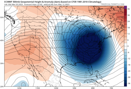
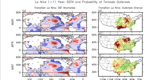
With La Nina seemingly on the way out, I expect the atmosphere will slowly respond to the transition much in the same way as the last few years. We are very likely to continue with La Nina-like atmospheric conditions across portions of the Southeast and southern Midwest through late winter and early spring. Those are fairly conducive to active severe storms through the remainder of February through March and early April. Looking at Ensmebles, there is already a strong signal for an early spring with above-average ridging over the SE and an active mid-level jet and potential troughing over the western and central CONUS through the next 30 days. CPC is on board with this showing huge warm anomalies over the eastern half of the CONUS through early Spring. Precip anomalies are also suggestive of an active wave pattern that we are seeing manifest through the next several weeks. Don't pack away your snow shovels quite yet as I think we are still in for some cold shots, but I think Spring and chase season are likely early and coming in hot! I expect a quick start this year with several big chase days potentially showing in Feb/March. As we continue the transition to El Nino, the Trans Nino Index (TNI = [Nino 1+2 -Nino 4] Regions) is starting to build some very large positive anomalies (+1.7). See this paper for a breakdown on TNI and its potential skill in predicting tornado outbreaks. Basically, large positive TNI values from transitioning La Ninas suggest active tornado potential early in the season across portions of the southeast Midwest and eastern Plains. Given everything else I've seen with the pattern, I think we might be in for some large outbreak days early.


A few things remain unclear to me from a seasonal perspective. One, the drought while improving over the West is still quite several in parts of the southern and central High Plains. I'm not sure thats going to change much between now and April. Secondly, as La Nina fades and we undergo full ENSO transition, the large-scale forcing should weaken and we may end up in a bit of a "no man's land" for the overall pattern. Without substantial El Nino or La Nina-like conditions, its anyone's guess exactly what the back half of the season might look like? But with that and everything else I've mentioned in mind, here's my guess for 2023!
2023 Spring Chase Season Forecast (MAMJ)!
Counts: Above Average (775 tornadoes across the CONUS during spring (MAM), 1400 plus or minus 50 for the year)
Outbreak Days (10+ Tornadoes within 6 hours): Above Average
Number of EF2+ tornadoes: Above Average (Greater than 1 STD Above the normal mean)
Chase Ability (7.5/10): Still opting slightly conservative here as I expect good numbers in places that are still challenging to chase. But, I think Plains chasers get a bit of relief this year.
A couple of notes, I'm choosing not to use analogs for this forecast as I haven't found any that really match all that well. Im targeting the top half of the distribution this year for a couple of reasons. My primary reasoning is the likelihood that we have an active early season and a more average back half. The GOM is above average and we have already seen anomalously high dewpoints make it back into the CONUS over the last few events. With everything prior about the active wave pattern and favorable ENSO state, I suspect March and April will be above normal. I expect the lower MS valley will be active early this season with the prominent ridging farther southeast keeping them warm. The Mid to Upper MS Valley, Midwest, and Ohio Valley should get in on the action as well with a potentially very active corridor shaping up here early to mid-season. As La Nina fades, things get more complicated. The primary driver for the past several years of bad seasons has been the sharp drop off in activity from mid to late spring into the summer. I suspect this has to do with the lack of persistent southeast ridging and quickly retreating flow aloft. I don't see much of a signal for that this year with the NMME and CPC vying for semi peristant western/central US troughing and a strong ridge down south. I don't expect a gangbusters year for the southern and central Plains, but more average activity. If El Nino conditions develop early, we might even approach some higher-than-average numbers as large-scale forcing would potentially shift preferential troughing farther west.
Now before you think I wish casting let's look at some potential negatives. Number 1, the western US drought remains and extends into parts of west TX, OK and KS. There has been substantial drought improvement over the Intermountain west and California over the winter. I expect some additional improvement but it likely won't be gone as there are some pretty large anomalies. That could feed back into some problems with the EML later in the year for more weakly forced days. Number 2, Its not exactly clear to me where the preferential troughing may become established this Spring. Farther east as predicted by some climate ensembles keeps periodic northwest flow over the Plains. While not terrible, this might lead to a lot more MCS activity and fewer supercell/tornado days. Number 3, predictability is low for the second half of Spring and if ENSO doesn't behave it could tank numbers like the last few years. With neutral forcing comes any number of possible states. While I don't think it's overly likely that we end up in a very unfavorable pattern, the last few years suggest it's possible and that would likely drag numbers and chase opportunities down. We will hopefully know more as we get deeper into Spring and the ENSO evolution/upper pattern becomes more clear.

So, some big takeaways:
") Stay safe and happy hunting!
Stay safe and happy hunting!
Here's my forecast from last year.
Mar 2, 2022
A few days late but ill throw my final thoughts for a seasonal forecast for 2022 into the fire to be burned up by mother nature. Sadly, this has the hallmarks of another meh year. I've long be resistant to the idea of a weak decay La Nina or possible third-year Nina in favor of a shift to EL Nino, but I'm finally backing off that. There has been a substantial drop in sub-surface warming over the last few weeks which has stalled any Niño condition development. The most likely scenario for spring appears to be a gradual decay of La Nina into ENSO neutral. The MJO while more active as of late has shown minimal activity thus far which is also another negative. Add that to the ongoing drought in the West and you end up with analogs like 2009, 2012 and 2018. You see where I'm going with this... These weren't the worst years but they were easily bottom half of the distribution. I think we are in for more of the same. Somethings that could improve our odds, a stronger MJO later in the spring, and continued warmth in the GOM.
A grand summary, I expect not a great year for chasing. A few notable outbreaks are possible through March and April. I'd pay special attention to the Midwest and Mid South as these areas have historically done better in these years. The southern Plains will likely be limited in chase opportunities so take chances. The southern High plains look to be very quiet sorry TX Panhandlers and southern Colorado. Big question mark in the central and northern High Plains. Its a mixed bag in these years especially late, but the predictability of tornadoes in the summer is low. Below are the numbers.
Forecast 2022 Tornado Season (MAMJ) :
Counts: Below Average (600 tornadoes across the CONUS during spring (MAM), 1050 plus or minus 100 for the year)
Outbreak Days (10+ Tornadoes within 6 hours): Average
Number of EF2+ tornadoes: Below Average (Greater than 1 STD below the normal mean)
Enjoy my very scientific graphic lol. Good luck this year everyone!
Chasabillity Score: Average 5/10
Hey ma look no hands forecasting! Overall, (keep in mind these numbers are still preliminary) my call for 2022 being below average (1050±100) was right on the money with 1131 inflation-adjusted reports falling just below the 25th percentile! My total estimate for the number of tornadoes in MAM was also very close at 600 (755 prelim 642 inflation adjusted). I correctly predicted that it would be a very quiet year across the southern and central High Plains. The massive hole in the prelim reports map is almost prophetic of how bad drought conditions have been out west for a long time. The Midsouth and Midwest did show up in classic La Nina fashion with numbers way above average. I meant to highlight the Midsouth and Southeast but failed to do that on my graphic. I was also able to correctly predict that it would be an early season, and March/April really delivered running with near-record numbers for several weeks. It is quite remarkable the drop off in activity levels at the end of April into May and June! Spring essentially died, with only 2 days seeing 25 or more reports after mid-April! Finally, very similar to 2021, a late surge in events in the winter helped raise the overall average with several big days. Another hallmark of La Nina dominated years. I'll hopefully be able to look at some of the other predictions like sig tors and spatial anomalies in the next few weeks, but overall id say this forecast turned out well!
With 2022 out of the way let's look ahead to 2023. I see a couple of similarities and a few key differences. Taking a look at ENSO base states, it's clear we are in for a change. While the spring predictability barrier is still stubbornly there, it appears likely we are going to flip from La Nina to El Nino conditions either this summer or Fall. Warm anomalies are already intensifying off the coast of South America, and nearly all of the ensemble guidance hints at El Nino conditions developing within the next 6-9 months.
With La Nina seemingly on the way out, I expect the atmosphere will slowly respond to the transition much in the same way as the last few years. We are very likely to continue with La Nina-like atmospheric conditions across portions of the Southeast and southern Midwest through late winter and early spring. Those are fairly conducive to active severe storms through the remainder of February through March and early April. Looking at Ensmebles, there is already a strong signal for an early spring with above-average ridging over the SE and an active mid-level jet and potential troughing over the western and central CONUS through the next 30 days. CPC is on board with this showing huge warm anomalies over the eastern half of the CONUS through early Spring. Precip anomalies are also suggestive of an active wave pattern that we are seeing manifest through the next several weeks. Don't pack away your snow shovels quite yet as I think we are still in for some cold shots, but I think Spring and chase season are likely early and coming in hot! I expect a quick start this year with several big chase days potentially showing in Feb/March. As we continue the transition to El Nino, the Trans Nino Index (TNI = [Nino 1+2 -Nino 4] Regions) is starting to build some very large positive anomalies (+1.7). See this paper for a breakdown on TNI and its potential skill in predicting tornado outbreaks. Basically, large positive TNI values from transitioning La Ninas suggest active tornado potential early in the season across portions of the southeast Midwest and eastern Plains. Given everything else I've seen with the pattern, I think we might be in for some large outbreak days early.
A few things remain unclear to me from a seasonal perspective. One, the drought while improving over the West is still quite several in parts of the southern and central High Plains. I'm not sure thats going to change much between now and April. Secondly, as La Nina fades and we undergo full ENSO transition, the large-scale forcing should weaken and we may end up in a bit of a "no man's land" for the overall pattern. Without substantial El Nino or La Nina-like conditions, its anyone's guess exactly what the back half of the season might look like? But with that and everything else I've mentioned in mind, here's my guess for 2023!
2023 Spring Chase Season Forecast (MAMJ)!
Counts: Above Average (775 tornadoes across the CONUS during spring (MAM), 1400 plus or minus 50 for the year)
Outbreak Days (10+ Tornadoes within 6 hours): Above Average
Number of EF2+ tornadoes: Above Average (Greater than 1 STD Above the normal mean)
Chase Ability (7.5/10): Still opting slightly conservative here as I expect good numbers in places that are still challenging to chase. But, I think Plains chasers get a bit of relief this year.
A couple of notes, I'm choosing not to use analogs for this forecast as I haven't found any that really match all that well. Im targeting the top half of the distribution this year for a couple of reasons. My primary reasoning is the likelihood that we have an active early season and a more average back half. The GOM is above average and we have already seen anomalously high dewpoints make it back into the CONUS over the last few events. With everything prior about the active wave pattern and favorable ENSO state, I suspect March and April will be above normal. I expect the lower MS valley will be active early this season with the prominent ridging farther southeast keeping them warm. The Mid to Upper MS Valley, Midwest, and Ohio Valley should get in on the action as well with a potentially very active corridor shaping up here early to mid-season. As La Nina fades, things get more complicated. The primary driver for the past several years of bad seasons has been the sharp drop off in activity from mid to late spring into the summer. I suspect this has to do with the lack of persistent southeast ridging and quickly retreating flow aloft. I don't see much of a signal for that this year with the NMME and CPC vying for semi peristant western/central US troughing and a strong ridge down south. I don't expect a gangbusters year for the southern and central Plains, but more average activity. If El Nino conditions develop early, we might even approach some higher-than-average numbers as large-scale forcing would potentially shift preferential troughing farther west.
Now before you think I wish casting let's look at some potential negatives. Number 1, the western US drought remains and extends into parts of west TX, OK and KS. There has been substantial drought improvement over the Intermountain west and California over the winter. I expect some additional improvement but it likely won't be gone as there are some pretty large anomalies. That could feed back into some problems with the EML later in the year for more weakly forced days. Number 2, Its not exactly clear to me where the preferential troughing may become established this Spring. Farther east as predicted by some climate ensembles keeps periodic northwest flow over the Plains. While not terrible, this might lead to a lot more MCS activity and fewer supercell/tornado days. Number 3, predictability is low for the second half of Spring and if ENSO doesn't behave it could tank numbers like the last few years. With neutral forcing comes any number of possible states. While I don't think it's overly likely that we end up in a very unfavorable pattern, the last few years suggest it's possible and that would likely drag numbers and chase opportunities down. We will hopefully know more as we get deeper into Spring and the ENSO evolution/upper pattern becomes more clear.
So, some big takeaways:
- I expect an above-average chase year with above-average numbers of tornadoes, especially early. Combined with an average back half our numbers should be up.
- Several early-season events may produce a lot of tornadoes from the Mid South through the Midwest and eastern Plains. I would prepare to chase a bit earlier than average and be situationally aggressive. Positive TNI values favor increased vertical shear and moisture advection across the central US.
- I expect an average Plains year for the second half of Spring. This is the most uncertain part of the forecast and is conditional upon the ENSO and general flow state behaving. We should see some drought improvement.
- Things that can still go wrong:
- Northwest Flow over the central US mid to late Spring.
- Enhanced risk of Blue Sky Busts on the dryline late this Spring from a warm EML out west.
- ENSO misbehaves and keeps us locked in neutral conditions and weaker background flow. With the Spring predictability barrier still up, it's possible we don't switch and just keep neutral. That could go either way but generally favors lower tornado counts.
Stay safe and happy hunting!
 lol
lol