State of the Chase Season 2023

Status
Not open for further replies.
Welp, what optimism I had has been completely erased. The rest of May looks abysmal on virtually every bit of data I can find. Here's to next year, which will likely suck as well.
 
copy and paste your words and when the 15th comes ..and we're staring at the models then, let's see if it still applies ... bunch of negative nancy's !! lol hahaha, just kidding with you all, but hey, we might be chasing in Eastern Montana again like I did a couple years back, there were a few good days out there actually.
 
I'm going with Accu-x's wizard kid who says May will be epic.....lol

Likely heading out next Monday for a possible Wednesday and Thursday event. As others have noted (and now backed by the NCEP models), upper level support is void for an extended period after the middle of next week. Not sold 100% on this long term scenario yet.
 
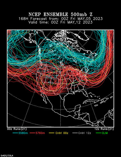
I know I shouldn‘t even be looking at the models for May 11 onwards right now...

Don't be so hard on yourself. There's nothing wrong with looking at medium and long-range deterministic solutions so long as you understand the capricious nature of the predictions. Also, you can still get a decent look at the larger-scale trend well beyond 1 week.

I'm going with Accu-x's wizard kid who says May will be epic.....lol

He always says that. That's like saying the sky will be blue today.
 
This just does not look good at all. You can still get NW flow events and some marginal high plains days with this look. But big outbreak/tornado days? Forget about it.

3.png
 
I'm thinking that if a period of active southwesterly jet stream does return to the Plains after the period posted above, it will be May 20th or later, possibly as late as May 28th into the first few days of June.

The first couple years I started checking the SPC outlooks daily, reading chaser write-ups on their websites (remember when those were a thing?; I also joined this very forum in 2004!) and otherwise paying attention to what was going on during the spring "chase season" in real time were my last two years of high school in 2003 (5/4-10, 5/15) and 2004 (5/12, 5/22-24, 5/29-30). At that point I thought all Mays had a period like that, the only question was when in the month. LOL.
 
This just does not look good at all. You can still get NW flow events and some marginal high plains days with this look. But big outbreak/tornado days? Forget about it.

View attachment 23769

I was considering admonishing you for not examining the penta-day averages that TropicalTidbits offers, but then I checked that product itself, and sadly, the 5-day mean surrounding that valid time looks almost identical to the snapshot value! :eek:

gfs-ens_z500aMean_us_9.png
 
I know I shouldn‘t even be looking at the models for May 11 onwards right now but boy, do they look ugly. Looks like a complete shutdown of 500mb flow just in time for our arrival. For what it’s worth, we had years where everything looked awesome one week out, just to get completely obliterated in the following days, so maybe, it‘s better this way around.

I can definitely empathize with you guys that invest the time and money to come over from Europe, only to be disappointed… But don’t lose hope! Every year in recent memory has looked like crap in the long range, but often yields one or two mesoscale events that make everything OK.
 
Continuing to see a period of extremely low predictability in medium and long-range guidance as has been mentioned above. A few chases look possible with the broad trough over the Rockies through the next few days. Beyond that, about the only thing I can say is that there is a somewhat consistent ensemble signal for some southwest flow with some sort of trough 510-5/14 ish that may foster a few chases. Looking ahead, there is signal for a major weakening of flow aloft. However, the guidance completely diverges on the solutions with that and its tough to draw many conclusions. This is one of the lowest predictability stretches I have seen in a long time. Not getting warm and fuzzy feelings given this looks like a summer pattern already. However, some mesoscale days may show up and again predictability is exceptionally poor.
 
My main chase vacation starts May 20th but I was thinking of doing an additional, short trip for this coming Wed/Thu/Fri since I can work remotely. I have been looking closely at the models for the period and no longer inclined to make the trip. Just like SPC has a higher probability threshold before putting up a Day 4-8 risk, I have a higher bar before I am willing to deal with the time, money and hassle of a short trip like that. I am limited in how much work I can miss this week - which would mean doing most of my positioning late Tuesday night so that I can work at least a half day on Wednesday. Just doesn’t seem compelling enough. For Wed, the Euro keeps the 500mb flow west of the moisture. GFS does have some co-location of moisture and flow in the TX PH, but with the GFS’s progressive bias I’m not going to bank on that happening. There could be some marginal opportunities for severe on Thu and then nothing much looks to be happening on the southern Plains Fri (which would be a “lame duck day” for me anyway, having to get back home on Sat).

As far as the longer term, it seems like the same negative sentiments appear here every single year. That could very well be because we haven’t had a truly classic “old school” season for many years. But look back and you’ll see that there were still some great days in almost all of those years. For me, 2013 is the gold standard of seasons that even now are looked at negatively for lack of sustained activity over the length of the season, yet had the most packed two-week sequence that I can recall in 27 years of doing this. (And I say that despite personal bitterness for failing to capitalize on any of it 😏). 2016 was another generally lackluster season dependent upon mesoscale events, but which yielded both Dodge City and Chapman.

So for now, I am holding out hope for the period that begins the 20th. Admittedly, those who have their chase vacations sooner will have a different view; believe me, I’ve been there, and I get it… I may be in your shoes two weeks from now… But this year is also a little different for me because I can work remotely and stay out there beyond my two week vacation. I will be limited in how much more work I can miss, but just being out there is beneficial if a big event happens to present itself, as often seems to happen in Junes that follow a quiet May… Believe me, if there‘s a Pilger type event in the horizon I’ll find a way to chase, regardless of what’s going on at work - it’s a helluva lot easier to do while out there than it is being home in Pennsylvania! 😏
 
Not getting warm and fuzzy feelings given this looks like a summer pattern already. However, some mesoscale days may show up and again predictability is exceptionally poor.

This is what I remember happening in 2021. The upper flow retreated north really fast, Spring was terrible for the plains, But there were several mesoscale days in Montana / North Dakota that were actually pretty good. a 3 day stretch actually. I'd also like to point out that my earlier post with the NMME probability products, I summarized split flow in May with some better troughing in June. It appears this is continuing to show up in the CFSv2 to some degree through May, at least in the form of low confidence and rapid Jet pattern changes, which reminds me of the full on La Nina we had years 2 years ago. Kinda makes you think about the lag of Tele-connections; perhaps the low Sea Ice content up north this year (well below the interquartile/interdecile average), maybe it's a factor on why the jet retreats so quick as things are always trying to balance between ocean heat and ice content. Just a guess though.

Either way, I figure that with the way things look currently, I'm not changing my dates, but, it's going to keep my trip decision inside the 180hr point to go or not go. No sense in going if there is only going to be 1 event in 10days, but 2 or 3? and I'll roll, because I will make it worth it, regardless if anything touches the ground.
 
It has looked pretty quiet recently, but I pretty much cereal guy'd it when I took a look at the medium-range statistical forecasts today:

7ksxv9.jpg

Screenshot 2023-05-06 at 15-01-39 cfs_week2.png (PNG Image 1020 × 852 pixels).png
Screenshot 2023-05-06 at 15-01-35 gefs_week2__CTRL.png (PNG Image 1020 × 852 pixels).png
Screenshot 2023-05-06 at 14-57-58 CFS Severe Weather Guidance Dashboard.png

7ksxww.jpg

I don't totally know what Victor's "Accumulated Supercell Composite Parameter" field actually is - is it the maximum SCP value over the time period or the summation of the SCP values over the time period? Or is it something else, like the number of occurrences of SCP exceeding some threshold (like SCP > 1) over that period (like a summed binary field)? In any case, the fact that it is 0 over most of Oklahoma during that 7-day stretch is probably a really bad sign for mid-May activity.

tommy_boy_giphy.gif
 
I'm going into 100% "stand-by" mode. Not only is the forecast screwy, it's a trap for those like me who like to go out and stay for a month (+). Something of interest is likely towards the middle or end of next week. After that, it's almost like a monsoon pattern in the SW sectors. Lots of rain but zero shear. The CFS (as seen in Jeff's post above) has a deep blue hole of doom for the middle of May. Looking more and more like a late May / early June chase (NW flow and Denver cyclones).
 
Status
Not open for further replies.
Back
Top