State of the Chase Season 2023

Status
Not open for further replies.
This is the GFS precipitation forecast for May 7-11. While I believe this should be used with great caution, there are signs of dryline storms as well as more general thunderstorms in Kansas.

Both the Canadian and ECMWF show troughing over the Intermountain Region during that period. While it would be somewhat more favorable for the mean trough to be at the longitude of the Four Corners, this isn't a bad solution.

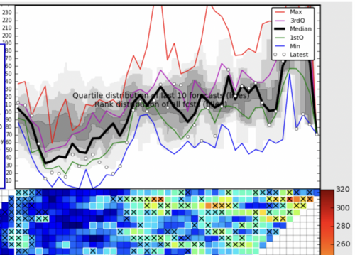
Even the chiclets are showing greatly increased activity after about May 12 through the end of the period in the first week of June. Considering these are different models that use different initialization methods, this would seem to add some confidence to at least normal severe thunderstorm events during the period.
Screen Shot 2023-04-26 at 3.07.13 PM.pngScreen Shot 2023-04-26 at 3.11.11 PM.png
 
The storm system that came through CO didn't give me any snow, but certainly got a decent amount of rain out of it.

The one thing that really surprised me is there was one cell that actually dropped a small tornado up in Weld county. I wasn't expecting to see anything like that when I looked at radar! 1st tor of the season I believe?

If that had been a longer lived system (and a different day/time when it woulda been an option) I would have been tempted to try going on a chase..

--------------
Have another chance of rain/snow coming tomorrow night. I'm personally hoping this is the start of what will be a wet spring.
 
We went thru a period where you could pick your chase days by looking at upper air on models 6-7 days out. This is when SPC had areas 6-7 days out. Then we had a slow down with not much going on. Last week and this week have been more active - but picking days and targeting has been much harder. SPC has done a great job of having generally accurate areas a few days out despite the uncertainty in the forecast.

Last Wed 4/19 had morning CAM runs showing no convection in the target area, but a closer look showed the models barely missing the convT with everything else being amazing and morning obs temps were warmer than the forecasted temps, so while we had worries of a bust, it was worth taking the chance and it turned out to be a big day. Tues 4/25 was another day where models didn't really want to fire either. A closer look showed models saying it was almost 10 degrees too cold to get storms. That morning I told my chase partner I was going to have to wait to midday to make a decision. We saw a very small grimier of hope, so we went out and once again it was a great day. Yesterday Wed 4/26 models where more robust on convection. They were correct - we had a mess of storms, and it was not our best chase day as a result.

My point is this - there is a lot of uncertainty in this period we are in now. But unless you can chase every day, it is really hard to pick the best days right now. Some of the days with the most certainly of storms are not great chase days and some of the high risk of bust days have been amazing. My reco is don't sweat it and take some chances. I think there are still going to be plenty of chances this season, especially if you take some chances.
 
Last edited:
End of April Update on my MAM forecast:

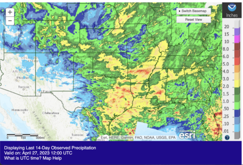
April, the verdict is an unequivocal BUST. The large-scale pattern beginning late the first week of the month shut down the vast majority of chase chances as troughing persisted over the eastern CONUS. Monthly tornado counts will be well-below average taking the top off the near record run to finish out March. Upper-level flow over chase alley was northwesterly with very little to show for it. A few chase opportunities did show up this week as the MJO forcing did allow some jet energy/troughing to sneak into the west side of the Block. But by and large, much of this April will be relegated to the trash heap. The benefit was lots of rain. The upper low turned into a serious "drought denter" dropping nearly 4 inches of rain at my house in Norman in just 10 days. Much of the high Plains also got in on the action as well with widespread 1-3 inches of precip reported in the last week or so. With some additional light rain tonight, D4 should be reduced some heading into May.
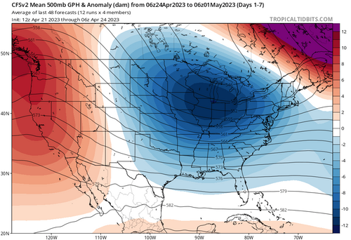
1682626161610.png

Screenshot 2023-04-27 at 3.12.18 PM.png

Now looking into the future, there's bad news and some potential good news. I'll start with the bad news:

BAD
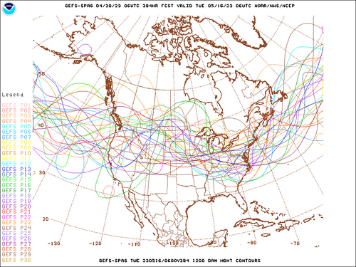
Expect much of the same from April for the first week of May. Overall conditions look quiet for chasing through the first week of May. A large Omega Block is set to form in the next 2-3 days centered near the Rockies and Great Basin. The eastern node of the block is expected to focus a large upper low over the eastern 2/3rds of the CONUS. A second low should also develop over the West Coast. This is a strong block and will likely remain in place through the next 5-7 days after it develops. However, there will likely be a few mesoscale days as subtropical energy slides beneath the Block in this time frame, but the overall pattern is not great.
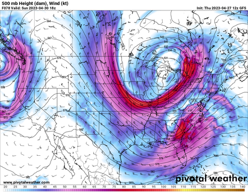
1682626798933.png

Now for some potential good. While Blocks like this are the last thing you want to see for May, there's still some hope. The overall forecast is not set in stone with several solutions pushing the block farther east or weakening it rather quickly. Models are notoriously poor at handling these types of situations and it's no surprise to see such variance in the solutions especially still several days out. My personal take is that we will see blocking develop, it will suck for a bit of the first week of May, but then something interesting happens...

Starting near the end of the first week of May, MJO forcing begins to increase quickly. The large-scale block is already being to break down as subtropical- jet energy picks up in the western node across the Southwest. There's relatively good agreement that the block lifts to the north as split mid-level flow and stronger westerlies begin to reemerge over the Rockies and Plains. This is well-timed with the increase in the MJO forcing as large-scale Pacific jet energy also begins to increase as we head into the second week of May.
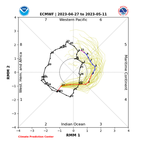
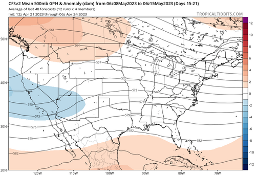
1682627534352.png
1682627552329.png

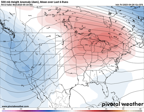
There's now considerable agreement on the weekly climate models and GEFS/EPS/CFS on western US troughing developing in the second week of May. Coincident with the MJO cycle, forecast velocity potential (large-scale rising and sinking air in the tropics) hints that a new ridge could start developing over the western Atlantic and Gulf. These solutions point to the amplification of the pattern and a potentially active stretch beginning roughly in the second week of May. The general trend sticks around through Week 3 before the aforementioned ridge starts to really ramp up toward the 4th week and into early June. I would expect that ridge to rapidly build into its climo position over the southern Plains and Mexican High Plateau by the last few days of May and the first week of June. But, zonal flow and some enhanced westerlies still look present over the central and northern Plains and there is a strong signal for above average Precip and PWAT anomalies on the Front Range and High Plains.
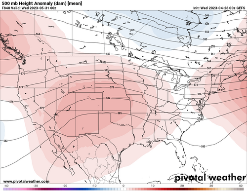
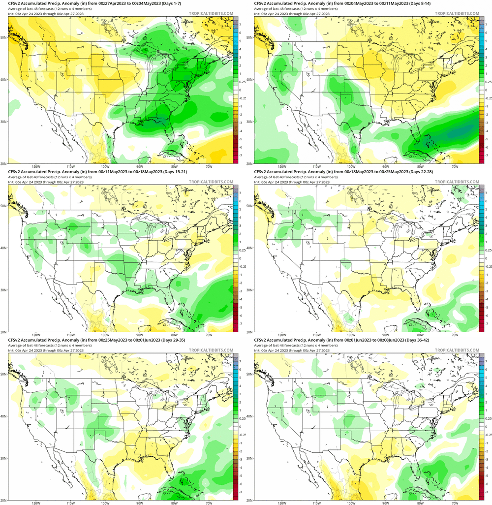
1682628268543.png


cfs-avg_apcpna_us_fh168-1008.gif

All this to say, I'm still cautiously optimistic that May will yield a good stretch beginning sometime late week 1 through much of the middle and end of the Month. The presence of increasing large-scale jet energy and MJO forcing in the next few days is a good sign to me that the pattern is going to get active despite the crappy start.


Takeaways:
  • April is a dud. Heh, I messed that forecast up :)
  • The first week of May will have a mesoscale-driven shot or two but, things look to be generally quiet.
  • There's good agreement that things could heat up the second week to mid-May as the MJO and westerlies are forecast to tick up.
  • The climo ridge should quickly build in late May. I expect a short Southern Plains season before things shut down and move north but it looks like there is a signal for MCS activity to linger, so drought concerns might be tempered.
  • The central Plains and Front Range are in the running for a decent Late May and early June if the pattern holds.

I could also be entirely wrong and things could suck, enjoy the uncertainty!
-Lyons
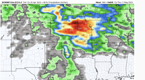
 
you're forgiven Lyons if what you just presented pans out in May 😄 , Cause I'm going out 26May to 5 Jun. I'll be keeping an eye on the MJO CFS and GFS models over the next 2-3 weeks.
 
Last edited:
My “official” two week trip is scheduled to begin on May 21 (flying out later in the day on the 20th, after my daughters’ dance recital).

But since I now, for the first time, have a remote job, I will extend beyond two weeks if things looks good.

I am also going to keep an eye on the weeks of May 8 and May 15 - I may make a couple short back-and-forth trips if things looks good. I can’t miss too much more work time outside of the ”official” two week vacation, so it would have to be a scenario where I could fly out at night after work, get fairly close to the target, work all day the next day, and chase in the evening. I have to get back for weekend stuff with family on May 13 and May 20, so these would be short trips - it would have to look *really* good and synoptically evident, to justify the time, money and hassle.

Similar for the extra time at the end of my two week vacation - I would have to be able to get myself to target areas mostly outside of work hours. But you know how it is, where there’s a will there’s a way. For the higher-end events I’ll find a way, but I’d have no chance at all if I wasn’t out there!
 
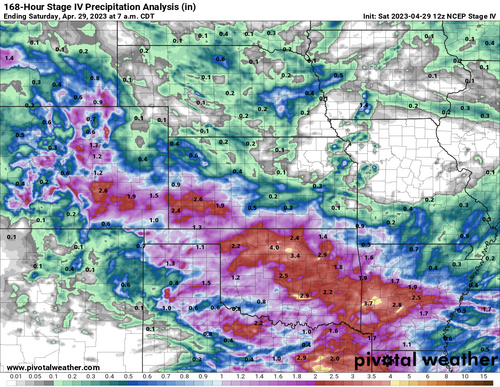
Just dropping in to post verification for the drought-buster (OK, drought-denter) event this past week, since these threads can be useful references for how a year evolved in hindsight.

stageiv_qpe_168h_p.us_c.png'

ahps-90d-percent.png

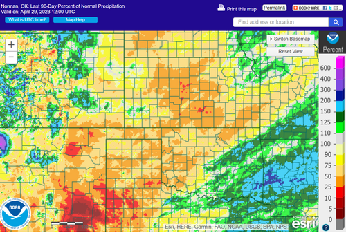
Overall, this was nothing short of a miraculous gift for parts of the southern Plains; particularly northern areas of the southern High Plains. Where a week ago 90-day running totals were 5-20% of normal in many locations of W KS and the northern Panhandles, we now see mostly 40-70% of normal.

Having chased seriously since 2007, I can't remember any other year that started out firmly in the "La Nina dust bowl" regime and then had an 11th hour (partial) save like this. Drastic recovery throughout March-April certainly happened in a couple of those years, but never a single game-changing event in late April.

Despite how fortunate this past week proved to be, I don't want to misrepresent the situation in absolute terms: most of the SGP south of I-80 is still in some degree of short-term drought, and areas like NE, N KS, and W TX only got scraps. But this should put most of OK, SW KS, and SE CO at a baseline where a couple MCSs the next couple weeks could really beat down short-term deficits.

Whether the jet stream will revisit anywhere in the CONUS besides the coasts soon enough for improved soil moisture and ET to matter is another matter entirely, of course.
 
This was a few days ago but gives you an idea of where we are at pre the small amount of rain received
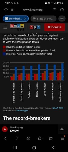
So while 2" of rain is great and a welcome blessing, when you look at the deficit it really puts things into perspective.
Screenshot_20230429-210226_Samsung Internet.jpg
 
Status
Not open for further replies.
Back
Top