State of the Chase Season 2023

Status
Not open for further replies.
I remain confident in the medium-range models, or at least the way they are trending. There should be a seasonal influx of decent dew points in about a week, or around the 8-9th., setting up for the traditional sneak attack event from May 11-17. Omega blocks do not concern me that much this time of year, although social media is in meltdown mode over the "death of the season." As Joel Ewing always says, "The horses are in the gates."
 
1. I'm gonna hold Lyons to his Spaghetti offer. (I'm available from 26 to 5 June; and I do like Garlic bread) 🤣
2. That plot looks like a bad pacemaker.
3. What do you think the cause of that is. is that just temporal distance from initialization? or a byproduct of it trying to figure out the Jet patterns, related to MJO teleconnections or the fact that the Nino pattern shifting is affecting some of that? (all of the above?)
4. to James's post: We know how much you like Ensemble Probability lol

My personal take is that models very much struggle with patterns like this. High lattitude blocking and variable enso states have been known to reduce Predictability significantly.

To be fair to james' point there isn't much signal for troughing yet either. But that was only a single northern stream contour spaghetti plot from 200 mb. Given I think this is be more of a subtropical jet year I'm not sure there will be much of a reflection in the northern stream of westerlies. Perhaps I should have picked a lower latitude GPH contour to better illustrate.

I am also a lover of garlic bread :p. Your chasecation lines up with mine the offer stands lol
 
Wooo!! sounds good to me!

I just mess with James a bit , he just seems a bit grumpy about this one particular time when the season brought Tornadoes that he missed lol so I can hear it in his posts about models to 🤣
 
My personal take is that models very much struggle with patterns like this. High lattitude blocking and variable enso states have been known to reduce Predictability significantly.

To be fair to james' point there isn't much signal for troughing yet either. But that was only a single northern stream contour spaghetti plot from 200 mb. Given I think this is be more of a subtropical jet year I'm not sure there will be much of a reflection in the northern stream of westerlies. Perhaps I should have picked a lower latitude GPH contour to better illustrate.

I am also a lover of garlic bread :p. Your chasecation lines up with mine the offer stands lol

I want to make sure the fundamental underpinning of that spaghetti chart isn't lost. You showed a 384-hr forecast - synoptic scale predictability is nil at that range, so you should expect to see such a look to ensemble contour fields like this.
 
Gotcha Jeff, and all joking aside, sometimes I ask myself why they even take it that far when you can expect that kind of outcome in the first place. it makes you think they should stop the run after the confidence drops below a notional or expected threshold. I am not sure at what forecast hour that would really be though. 180? 270? ... but it feels like 180 is where I tend to see those breakdowns really occur
 
Gotcha Jeff, and all joking aside, sometimes I ask myself why they even take it that far when you can expect that kind of outcome in the first place. it makes you think they should stop the run after the confidence drops below a notional or expected threshold. I am not sure at what forecast hour that would really be though. 180? 270? ... but it feels like 180 is where I tend to see those breakdowns really occur

The threshold at which predictability becomes lost varies, but there could be events for which forecast hours > 300 offer value still.
 
View attachment 23532
Somebody sees something coming.

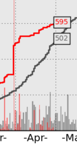
The Trimmer man is out with his latest hypecast:
His previous post did contain a major tornado outbreak, but it was more or less just one event rather than week after week of big events. Remove the 31 March outbreak and you get a pretty quiet April...certainly below average.
Screenshot 2023-05-02 at 11.24.50 AM.png

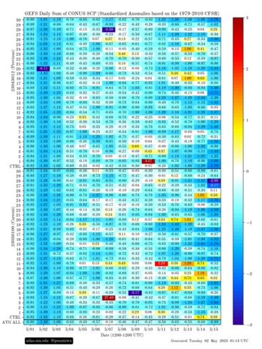
Meanwhile, the latest medium-range statistical forecasts suggest not to get your hopes up too much:

gefs_scp_stda_chiclet.png

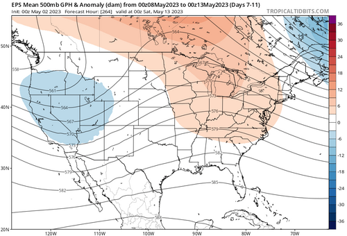
I'll be participating in the NOAA/NSSL Hazardous Weather Testbed Spring Forecasting Experiment next week, and I've had a scary tendency to absolutely destroy severe activity during my week in that experiment, so I apologize in advance. However, the ECMWF suggests there will at least be troughiness over the Rockies. However, the center of the low height anomaly appears displaced just a tad west of where you'd want to see it to feel good about an extended period of severe weather potential.

eps_z500aMean_us_7.png

But who knows...at this range, more-favorable scenarios remain possible.
 
Didn't we have Tim Marshall posting on Facebook that May will be dead due to a persisting Omega block yesterday or the day before?

Only sure thing about this pattern is that predictability beyond a few days seems to be close to nil. No confidence of any major troughs locking in but neither that such a hostile pattern will lock in, either.
 
The Trimmer man is out with his latest hypecast:
His previous post did contain a major tornado outbreak, but it was more or less just one event rather than week after week of big events. Remove the 31 March outbreak and you get a pretty quiet April...certainly below average.
In fairness, if you remove outbreaks, most Marches and Aprils are going to look quiet. 4/19 was also one of the better Plains dryline days in recent years.
 
Not sure how the passage of a left-side low from an Omega block is a signal of things to come for an entire month, but I'm not a Ph.D. Anyone can look at the forecast for the next few days and conjure up a good chase or two from looking at Pivital Weather's Supercell Index or reading the SPC outlooks. Hype is good for business if you are living off YouTube likes as few people remember busts, just big events.
 
However, the center of the low height anomaly appears displaced just a tad west of where you'd want to see it to feel good about an extended period of severe weather potential.
With the usual caveats that it's still almost a week out, I'd agree with the above. Seems the troughing remains mostly too far west and the moisture too far east.
 
I know I shouldn‘t even be looking at the models for May 11 onwards right now but boy, do they look ugly. Looks like a complete shutdown of 500mb flow just in time for our arrival. For what it’s worth, we had years where everything looked awesome one week out, just to get completely obliterated in the following days, so maybe, it‘s better this way around.
 
I know I shouldn‘t even be looking at the models for May 11 onwards right now but boy, do they look ugly. Looks like a complete shutdown of 500mb flow just in time for our arrival. For what it’s worth, we had years where everything looked awesome one week out, just to get completely obliterated in the following days, so maybe, it‘s better this way around.

Was thinking the same thing while looking at the models. Lots of ridging being shown over the Rockies into southwest Canada. The silver lining is that the models are showing the southern stream staying active and some moisture still getting into the plains, so it doesn’t look like a total dead period. But there are no signs whatsoever of a deep trough in the west after next week.
 
Status
Not open for further replies.
Back
Top