State of the Chase Season 2023

Status
Not open for further replies.
On the one hand, I think that is fairly realistic with regard to long range confidence. I don't think anyone here has high confidence, but it will be nice if some of those large- scale teleconnections line up to present at least an enhanced probability that the synoptic pattern is neutral to favorable vice the complete opposite. On the other hand, skip the long range and just deal in 120hours or less, and the rest is right on, a good SW flow and DL and let the Meso-scale do the rest. Both are interesting, one is more fun, unless you're the type of person that enjoys 3-month predictions lol, there's no shame in either.
 
I put more trust in the NCEP Ensembles (NCEP Ensemble Weather Maps: NOAA Physical Sciences Laboratory) this time of year, when I'm trying to get some rough idea of when I need to start packing. I also read NWS afternoon forecast discussions, as the local experts are very good at long range forecasting for specific areas. Especially MAF, LBB, OKC, AMA, DDC and ABQ - early in the season. My conclusion (weighted by NCEP), is that we might have some return to a favorable pattern (more than a one day event) by the first week in May.
 
Aside from the general unreliability of long-range models, I am particularly cynical about those maps that present anomalies (temp, precip, etc.) for full-month periods. Aren't they just presenting an average? That's meaningless for chasing. That could mean two crap weeks and two good weeks, or one crap week and three OK weeks, or three crap weeks and one awesome week, or four marginal weeks but with plenty of mesoscale setups. For a chase vacationer, this comes down to a matter of schedule alignment more than anything else... For example, I still consider the last two weeks of May 2013 - generally considered to be a poor season - to be one of the most fertile chase vacations ever - the fact that I screwed up every day in some way or another is an entirely separate issue. 😒
 
I can't add much to the discussion of upcoming prospects for the pattern/wavetrain to improve. The rest of April will likely be quiet at best, and then we dive into peak season with tons of uncertainty. The majority of what I've seen from S2S experts has tended toward the bearish side, owing in part to ongoing persistently positive global AAM anomalies and the rapidly developing El Nino.

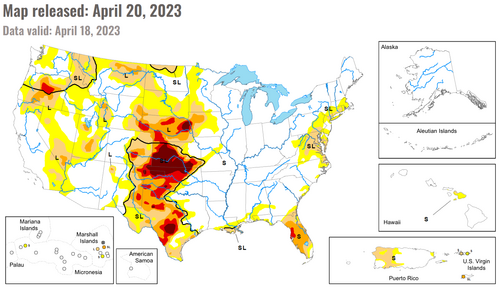
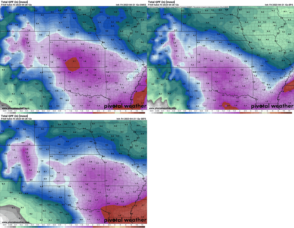
Like a broken record, my bigger concern is the boundary condition I can effortlessly wrap my dumb brain around: ongoing drought, which is quite severe from C/W KS and E CO into W OK and the Panhandles (essentially, the entire southern High Plains, extending a bit into the central High Plains). To that end, I think the miserably cool and quiet period next week could actually prove critical, as global ensembles show the potential for significant relief over parts of that region. Long-term deficits are so daunting that they will not be made up anytime soon, but alleviating short-term deficits matters most for the PBL evolution on storm days. So, I think any areas receiving 2-3" liquid equivalent over the next week will be meaningfully less prone to mixing out on chase days as we hit early-mid May. To be clear, even those optimistic totals would not swing the pendulum back to 2015-16 style greenery and rich evapotranspiration for these dreadfully parched areas... but it might significantly limit the "damage" drought can deal to any setups that materialize next month.

I'll be honest: before this possible slow-moving low showed up on the ensembles, I was struggling to find any positive signals for peak season. This drought is bad over a huge fraction of the best chase country (at least S of I-80), and we've seen time and again how readily that can decimate most of the subtle finesse type setups in late May and June. Bottom line: I'll be watching how the QPF forecast evolves the next few days about as nervously as I'd watch a big trough. If this can break our way with good coverage of soaking rains where they're needed, it would go a long way toward limiting the pressure of needing either big, synoptically ideal setups or fluky upslope shenanigans to muster anything good in May. If QPF dramatically dwindles this weekend, or shifts into the jungles... big yikes.

dm-20230420.png

models-2023042112-f168.qpf_acc-mean-imp.us_c.gif
 
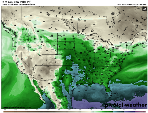
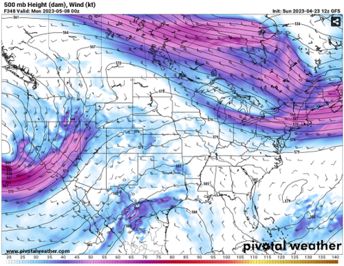
Looking at the models for the 1st week of May and GFS has been somewhat inconsistent. Earlier this week it was trending towards some events possibly on May 4th-9th but last couple of days it's blown those away and it looks like the activity will be sometime after May 9th ish. Latest CFS runs appear to be on board with this as well.

If I'm reading the solutions correctly (and I'm still new at this), even with a possible low moving through the plains mid first week of May, it's cut off from the moisture. And then when the moisture returns further north into Oklahoma etc., there's no mid-level flow. Looks like I'll be cancelling my chasecation from next week and seeing if I can re-book it mid-june (can't book it end of May this year unfortunately)

1682277563480.png1682277587438.png
 
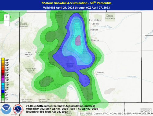
I know its not 'chase' weather (and probably even disliked by many) but...
I was kinda hopeing for a spring blizzard here in CO this year, for a couple main reasons.
* I actually enjoy watching a nice heavy spring snowstorm, seeing the snow fall & watching it stack up. (plus knowing it won't be around forever & create a big icy clusterfuck like happens if you get one in Dec/Jan/Feb)
* Its been sorta dry here lately, a nice thick blanket of heavy wet snow would certainly be good for everything / atleast for awhile help with drought issues.
(though its also a general spring wish even in non-drought years)


----------

There is actually a chance I might actually get that wish this year
Seeing the forecast this week, it looks like there is a decent chance of getting some good precipitation here (assuming ofcourse the closed low sets up in just the right location)...
but it also looks like its going to be not cold enough.. so allot of it will come down as rain instead.
I can hope though. If it gets cold enough we could end up with a pretty decent amount of snow.
(And rain is a good thing, even if thats all we get.) I might have to watch rhe models on this one.

Pretty much once you hit may, don't really want to get much snow, because the trees will start to bud & leaf-out.....
 
There is actually a chance I might actually get that wish this year
Seeing the forecast this week, it looks like there is a decent chance of getting some good precipitation here (assuming ofcourse the closed low sets up in just the right location)...
but it also looks like its going to be not cold enough.. so allot of it will come down as rain instead.
I can hope though. If it gets cold enough we could end up with a pretty decent amount of snow.
(And rain is a good thing, even if thats all we get.) I might have to watch rhe models on this one.

I'm in the same boat. Usually snow in Colorado means moisture and storms for the plains. And while the NWS winter weather models are forecasting quite a bit of snow on Tuesday / Wednesday, the temperature forecast doesn't seem to line up. Still, it doesn't really matter if it's rain or snow. I feel like moisture is moisture, and it will help regardless.

Now I'm trying to decide whether to ditch my family and head to south Texas on Tuesday, or hang out here and help shovel snow on Wednesday. But based upon the temperatures, I'm hoping the snow will just melt throughout the day on Wednesday and I won't have to shovel at all.

1682306010514.png

On second thought... maybe I should have done like the weather gurus on Twitter and posted the 95th percentile to get people hyped up. 🤔
 
ScottCurry said:
I feel like moisture is moisture, and it will help regardless.
Yep. so true, any form is still good! I'm personally really hoping it cools off enough for all snow.
I'm also up pretty close to the mountains, so there's that & being a bit higher than Denver. I expect something more than the city (pretty normal here anyway)

Now I'm trying to decide whether to ditch my family and head to south Texas on Tuesday, or hang out here and help shovel snow on Wednesday.
Heading south sounds more fun than shoveling .lol. but honestly even if it does end up being snow (and lets just say a decent amount), unless you're in the mountains, I wouldn't expect it to hang around long..probably be mostly gone by thurs! Only those north-facing areas/slopes haveing any left (that's one of the things I love about spring snowstorms)

On second thought... maybe I should have done like the weather gurus on Twitter and posted the 95th percentile to get people hyped up.
Oh yes, gotta over-hype things!! LOL

---
The one thing they did mention is there is a chance for some thunder...oh if that could just line up with the snowfall. Thundersnow! I love when one of those (very rare) storms happens. Certainly would like to see that, but not gonna get my hopes up too much.
 
A few new forecast data sources have come to my attention. The folks at NCAR have revived a few of their high-res forecast pages, but now using different modeling systems. These two forecasts will only run for the next month or so:


Don't forget about NSSL's experimental CAMS, available here: cams.nssl.noaa.gov, in particular, the MPAS runs.

Don't forget about WoFS, which is running in experimental mode around this time of year, too: Cb-WoFS - Home

Awesome resources thanks Jeff! Long Live the NCAR Ensemble!
 
A few new forecast data sources have come to my attention. The folks at NCAR have revived a few of their high-res forecast pages, but now using different modeling systems. These two forecasts will only run for the next month or so:


Don't forget about NSSL's experimental CAMS, available here: cams.nssl.noaa.gov, in particular, the MPAS runs.

Don't forget about WoFS, which is running in experimental mode around this time of year, too: Cb-WoFS - Home

I'm actively working right now with some folks who are engaged in MPAS development. Have you had experience with this at all and Voronoi Mesh?
MPAS (mpas-dev.github.io)
 
There's a lot of run-to-run variability which is to be expected, but by and large the CFS looks pretty uniformly awful for May. Lots of eastern troughs and if any trough does try to dig into the west, the 500mb flow is usually depicted just shearing out and dissipating over top of a Plains ridge. Doesn't mean it's right, but the relative frequency of this general depiction is discouraging. Any time it does show a workable western trough with strong southwest 500mb flow and spiking SCP over somewhere in the central CONUS, at some point during the run, it's gone the next run.

This is why, as fickle and hectic as early-season setups can be, I recommend chasing them if at all possible because so-called "peak season" is no guarantee.
 
I have not yet decided to delay my usual departure about May 5th. The ECMWF is hinting of some type of possible DL event around May 6th. The NCEP Ensembles hint favorable flow beyond that period. The CFS is also getting jiggy after May 8th. Just need to wait for the surface forecast to catch up and I'm out the door! If all else fails, then it's eastern Colorado and NW flow events in late May and early June.
 
Status
Not open for further replies.
Back
Top