State of the Chase Season 2023

Status
Not open for further replies.
Adlyons,

I realize that you do the seasonal outlooks and so far, I think your geographic coverage looks pretty on. I was wondering if you thought about a quarterly update. say for MJJ. based on what's happened up to now, and if any of the larger scale patterns from your original forecast would shift the map any. what do you think about that.

Hey Jason, I am going to post a follow up today since it looks like we finally have the March numbers sorted. I was planning to do an update for the rest of April and into May.
 
All, here's a quick update on the state of the forecast.

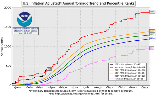
We are waiting for the official prelim count for March but using some of the tools we have here, my very prelim tornado count using the available PNSs for March 1-31 is 174!!! The 25 year average for the month of March is 84 tornadoes. I have not done any other looking at the distribution yet to find the standard deviations or terciles, (Its been busy...😩) but I am confident this is probably in the upper 75th+ percentile of tornado counts for all Marchs!

So far the forecast for a very active early season has been correct. We are at or slightly above record counts for the first part of Spring. 1680788060580.png


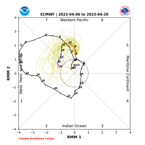
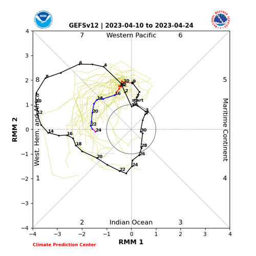
My original forecast called for an active April. Looking at models so far, that will not be the case for the first couple of weeks. The Rosby Wave train that has been harassing the lower 48 for the better part of the last month has finally shifted and we have seen ridging build back into the western CONUS. But, the ridging looks rather transient as the MJO looks to remain amplified. This is matched by the ensembles which show below average PWAT over the CONUS for the first half of the Month.
1680789160011.png

However, as we move into the back half of April, things start to look more interesting as the MJO prepares for another 8-1-2 transition. This seems to be matched too by climate ensembles which show western US troughing redeveloping mid to late April into May. There's a lot of uncertainty but with current trends, and April could finish more average to below average given we are losing the first half of the Month. But as things potentially heat back up, we will be in a highly favorable climatological time period for large outbreaks and the chance to stack up reports quickly as we head into the heart of chase season. May could still go either way which is why I am sticking with average. there are hints of above normal precip in the Plains and some favorable western US troughing, but there are also some indications of less favorable patterns. Summer is a crapshoot as we approach minimal large-scale forcing.
 
Here is another quick update as we get into mid April. Things are still quiet, with several bouts of blocking and a cut-off low lingering in the Gulf, and I expect that won't change, probably for the next week or two. Given we are missing at least the next 10 days for significant bouts of severe, I feel pretty confident April will not end up being in the above-average category for tornado counts. (avg is 187) We will likely have a few smaller days in play, but the brunt of the pattern looks quiet.

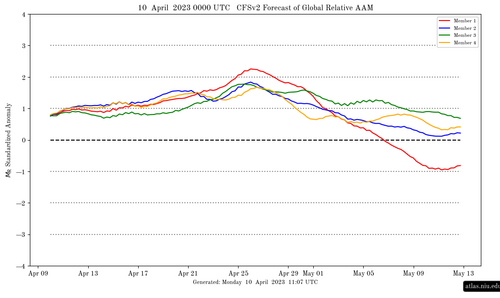
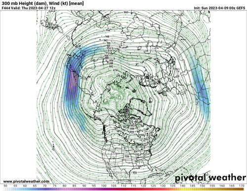
However, there is a very interesting signal emerging for the last part of the month. The MJO signal I mentioned previously has continued to ramp up. As we've transitioned to a more stable pattern of mid-latitude blocking, atmospheric angular momentum has started to build. That looks to continue until about the 3rd week of April. Based on the work by Gensini et al., building momentum, enhanced by a favorable MJO, is partly responsible for Pacific westerly jet extensions which eventually break down and lead to western us troughing. Already there is a strong MJO signal for an 8-1-2 transition at the end of April through mid May. Reaching far out into the Ensmebles, the GEFS also hints at a very similar pattern to earlier this year with a large Pacific ridge favoring enhanced westerly flow and a possible jet extension into the western CONUS in a few weeks.


1681152298854.png
1681153059549.png
1681152471596.png

There are of course still details to be worked out, ie eastern us troughing, but there are some potentially good signs for chase season. Late April will likely see an uptick in sigificant severe weather as early as the 20-25th. As we move deeper into spring, seasonal forcing weakens and flow tends to become zonal and weaker. Jet energy into the western us would favor lower amplitude flow with the potential for a broadly supportive severe area over much of the Plains, not much different than average climo. IMO these low amplitude dryline stretches are some of the best for sustained chasing. it will be fun to see how things evolve over the next few weeks as we all prepare for the annual migration lol. Contain the hype, atleast for now ;)

1681154247500.png
 
I agree with adlyons that it looks pretty quiet for the next two weeks. Medium-range models showing a reasonably active polar jet stream, but the storm track will be displaced to the north of where you'd want to see it for April on the Plains. Pentaday averages from major global ensembles even hinting at anomalous ridging over the high Plains through day 16, which is most of the rest of the month of April. Dynamical supercell specific outlooks also show a lot of negative activity anomalies through this time, so I suspect the calmer pattern will stick around for a while.

Sadly, this seems largely consistent with the activity pattern in recent years - March has become a very active month most years, but then things calm way down as we head through April into May, and we end up with a pretty lackluster peak spring season on the Plains. While I'm hoping against that this year, I'm starting to have a sneaking hunch that that is exactly where we're headed yet again.
 
Based on the 12Z runs Monday, I think we have a shot at a localized severe weather situation Friday afternoon and evening in KS east of the Flint Hills, western 1/3 of MO, and northeast OK.

Of course, this is very far out, but it is something to keep an eye on.
 
I'm also concerned about the long range forecast, but I get to see my friends regardless. So it's either the Drunken Oyster and bourbon in AMA and/or mesoscale sneak attacks coming off the caprock, or eastern NM/CO freaks of nature.

Seriously, I've seen very few longer range (>15 days) forecasts verify enough to trust them. As Chuck Doswell once told me, "40kts. shear and DP over 55 'can' do it out west. The good thing about funky forecasts this time of year is that it keeps the chase circus further E/NE. A lot of chasers will not venture too far west on marginal days.

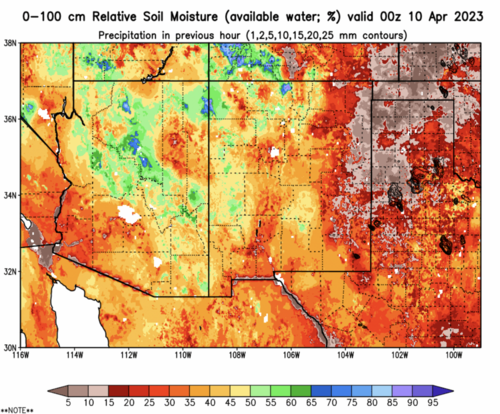
The western Plains are very dry right now. (See attached). Not sure the dryline will want to stick around. A lot can happen in a few weeks so we will patiently wait it out..... like ever year.
 

Attachments

  • Screen Shot 2023-04-10 at 2.34.46 PM.png
    Screen Shot 2023-04-10 at 2.34.46 PM.png
    1.8 MB · Views: 0
One part of me likes the fact that it's not so obvious. Maybe the targets will be more sporadic and challenging reducing the chances for a Hoard attack over a single location. But these days, technology has made it super easy. SPC and a phone and you're an "expert". lol
 
One part of me likes the fact that it's not so obvious. Maybe the targets will be more sporadic and challenging reducing the chances for a Hoard attack over a single location. But these days, technology has made it super easy. SPC and a phone and you're an "expert". lol

Not to go OT, but I’ve been doing this 25 years (albeit just as a chase vacationer, so it doesn’t add up to nearly as much time actually chasing as it does for some people), and there is no way that I would ever call chasing “easy.” Unless you mean “easy” like hitting a baseball is easy, where a .300 average is considered success. Unless I just suck at it.
 
Not to go OT, but I’ve been doing this 25 years (albeit just as a chase vacationer, so it doesn’t add up to nearly as much time actually chasing as it does for some people), and there is no way that I would ever call chasing “easy.” Unless you mean “easy” like hitting a baseball is easy, where a .300 average is considered success. Unless I just suck at it.
A .300 average would be a hell of a career as a chaser imo! I think most of us bat more in the .100 or so area. Then again I was a wrestler and pretty terrible at baseball :)
 
To go with Warren's point - another difficulty we've seen for Plains chasing the past several years is with the dryline - we aren't getting "tight" DLs with huge moisture gradients over very short distances a la typical cold fronts. Rather, we've seen diffuse "moisture drop offs with westward extent" across the region where we typically see DLs on the high Plains. Not having that tight dryline to help fire off storms into environments with rich moisture...ugh
 
James, "expertise" was intended to be completely rhetorical lol. More poking fun at oversimplification. "what has two thumbs and isn't an expert?", " This guy!"

to this DL piece though that Jeff mentioned, is there some sort of "idealized" DL gradient? say 10,20,30 degs of DP loss over 20miles? over say 100miles? I see DL all the time on the models and would say, "ok, I see the dry-line", and yet I guess I never considered that there might be a dry line that was more diffuse over sharp and if there was some kind of rule of thumb or not, or if it were just more intrinsic to the forecasters eye.
 
to this DL piece though that Jeff mentioned, is there some sort of "idealized" DL gradient? say 10,20,30 degs of DP loss over 20miles? over say 100miles? I see DL all the time on the models and would say, "ok, I see the dry-line", and yet I guess I never considered that there might be a dry line that was more diffuse over sharp and if there was some kind of rule of thumb or not, or if it were just more intrinsic to the forecasters eye.

The way I see it, the quantity of the moisture gradient is not particularly important - it's just that larger and tigher is better. The dewpoint gradient along a dryline is actually more a result of the strength of the dryline circulation, which is what we actually care about, since it's the dryline circulation that forces CI. Of course, we want high moisture content east of the DL since it promotes higher CAPE and lower CIN, but no matter what the dewpoints are, you need a stronger dryline circulation to get storms to fire in the first place, especially when there are no synoptic scale troughs or other large-scale forcing to promote storm development. Drylines in synoptically quiescent environments with moderate CAPE can be behind those days where there are only 1 or 2 isolated supercells with clear skies for great viewing on the high plains. This is the "days of old" style chases that most long-time chasers prefer.

The one necessary condition to look for is the width of the moisture gradient. If the main moisture gradient covers 100 miles or more, then you're looking at a diffuse "dryline" that could barely even be called one. You want to see moisture gradients over less than 50 miles to suspect there is a solid "dryline" with an associated circulation.
 
Status
Not open for further replies.
Back
Top