State of the Chase Season 2023

Status
Not open for further replies.
ok I can buy that for a dollar for sure and I appreciate the specifics on diffuse vs. tight.

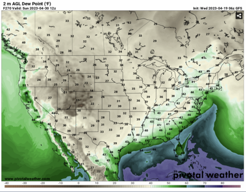
In terms of dryline circulations though, these are diurnal in general so, does the strength/size/shape of the EML source region have anything to do with enhancing or diffusing the dryline circulation at all? or is it all subordinate to the mid and upper-level synoptic patterns effecting SFC pressures and tightening these circulations/gradients. It makes the most sense to me in terms of synoptic forcing, but I assume there also has to be a Microscale environment that comes into play). I just started looking at a 2007 David M. Schultz paper on dryline intensity which should be interesting.
 
Finishing up at the NTWC and finally had some time to look at the latest long range models (GFS and ECMWF High-Res). Whaaat? Models are in very good agreement of not moving any DP's > 45 degrees west of an ICT/OKC/MAF line for at least 10+ days, except for a possible / single DL event around the 20th., that may mix out even further east.
 
This is the time of year that I prefer to see a dearth of activity… Last thing I need is for an early start to the season, which in my anecdotal experience usually means an early end. Just my perspective as a chase vacationer; I know those that live on the Plains have a much different view…

I may finally have the opportunity to work remotely and spend more than a lousy two weeks on the Plains this year, but any “extra” time is likely to be at the back end of the season, into mid-June; it’s still going to be impossible for me to station myself out there before May 20, although I could probably do one or two out and back trips, as inconvenient and costly as they may be, if it’s really worth it - but still not before May.
 
I've been frantically checking the model runs for last week of April into May for the past 2 weeks and the solutions just cannot get aligned. Latest checks on the he CFS, GFS, and ECMWF are all STILL showing differing results, with varying amounts of storm days and areas.

As someone with a Chasecation who had to book my chasecation in late April-early May this year, I have a conundrum. Do I assume the ridge will set up and reschedule chasecation for Mid-June and hope for the best, or do I take my chances that there will be something to chase that's worth seeing?

Personally, I'm becoming more and more partial to re-booking, just based on the fact that the chase days this year have shown up fairly consistently to date, and if a ridge (or partial ridge, or whatever you want to call it) does get set up, even meso-scale days will be out of the question. But in early June, there's more likely a chance for NW flow events, etc. that can cause at least some beautiful structure in the high plains, and with the transition to El-Nino occurring (I guess technically we're Neutral right now), there may be some opportunities.

All this to say, I'm suspecting based on models that the season will be mostly quiet the next couple weeks and into May (besides April 20th), with hopefully some action returning for late May and into June. That being said, I'm quite new at long range forecasting, so curious as to what everyone's thoughts are for the coming weeks/months based on what we've seen.
 
With this current set-up, RH is the King if you are seeking to chase in the traditional areas of the Plains, e.g., anywhere of west of a ICT / OKC / MAF line. The models have continued to signal an event (or events) around the 19th.-20th., but after that, it's goodbye RH though the end of the month according to the GFS and the ECMWF.
 
The way I see it, the quantity of the moisture gradient is not particularly important - it's just that larger and tigher is better. The dewpoint gradient along a dryline is actually more a result of the strength of the dryline circulation, which is what we actually care about, since it's the dryline circulation that forces CI. Of course, we want high moisture content east of the DL since it promotes higher CAPE and lower CIN, but no matter what the dewpoints are, you need a stronger dryline circulation to get storms to fire in the first place, especially when there are no synoptic scale troughs or other large-scale forcing to promote storm development. Drylines in synoptically quiescent environments with moderate CAPE can be behind those days where there are only 1 or 2 isolated supercells with clear skies for great viewing on the high plains. This is the "days of old" style chases that most long-time chasers prefer.

The one necessary condition to look for is the width of the moisture gradient. If the main moisture gradient covers 100 miles or more, then you're looking at a diffuse "dryline" that could barely even be called one. You want to see moisture gradients over less than 50 miles to suspect there is a solid "dryline" with an associated circulation.

This is what I'm talking about when I say "tight" dryline. Too bad the moisture quantity on the moist side isn't quite as good, though. But that gradient...sexy! And look at its meridional extent...all the way down through Mexico City pretty much! That's one hell of a source of dry air over the higher terrain of C/W Mexico right now.

Screenshot 2023-04-18 at 23-09-05 ruc00hr_sfc_dewp.gif (GIF Image 680 × 680 pixels).png

When you can see a dryline on satellite, it's a good dryline.

DL_IR.png
 
Hard to recall a bleaker ***trend*** in the long rage models, including the GFS, ECMWF and CFS. Sad to watch the little "chiclets" as they fade to blue from a once promising forecast. Things could flip, but I feel for the farmers and people who scheduled tours in April.
 

Attachments

  • Screen Shot 2023-04-19 at 7.46.46 AM.png
    Screen Shot 2023-04-19 at 7.46.46 AM.png
    1.7 MB · Views: 0
Thought I would contribute some MME products for May/June outlook.
 

Attachments

  • prediction_precip_northcom_exroa_1.png
    prediction_precip_northcom_exroa_1.png
    316.3 KB · Views: 0
  • prediction_precip_northcom_exroa_2.png
    prediction_precip_northcom_exroa_2.png
    317.7 KB · Views: 0
  • prediction_temp_northcom_exroa_1.png
    prediction_temp_northcom_exroa_1.png
    306.3 KB · Views: 0
  • prediction_temp_northcom_exroa_2.png
    prediction_temp_northcom_exroa_2.png
    306.3 KB · Views: 0
  • prediction_wind_northcom_exroa_1.png
    prediction_wind_northcom_exroa_1.png
    428.6 KB · Views: 0
  • prediction_wind_northcom_exroa_2.png
    prediction_wind_northcom_exroa_2.png
    442.1 KB · Views: 0
  • prediction_z_northcom_exroa_1.png
    prediction_z_northcom_exroa_1.png
    301.9 KB · Views: 0
  • prediction_z_northcom_exroa_2.png
    prediction_z_northcom_exroa_2.png
    289.9 KB · Views: 0
I’ve never before seen that 200mb wind speed and direction anomaly forecast that @Jason N posted… When the arrows are shown pointing from east to west, i.e. opposite the typical flow, is that supposed to be indicating weaker winds? Seems to makes sense based on the height anomaly but just wanted to make sure I understand the depiction.
 
I’ve never before seen that 200mb wind speed and direction anomaly forecast that @Jason N posted… When the arrows are shown pointing from east to west, i.e. opposite the typical flow, is that supposed to be indicating weaker winds? Seems to makes sense based on the height anomaly but just wanted to make sure I understand the depiction.


James: I chatted with one of the climate folks that produce the image, and they told me this CFS product doesn't put negative values on it for some reason, which he wants to get corrected. So, in actuality, those winds should be anomalously stronger during this period, not weaker, the motion vectors look inverse because they didn't attribute negative values on the legend below the image, so something was wrong there.

bottom line: stronger winds, split STJ/PFJ flow in May. Trough/Low over High plains WY; with a ridge over the NE, with stronger wind flows in the south, and a steep trough to ridge amplitude from Oklahoma to great lakes in June.
 
Last edited:
Love that the Plains had a traditional DL day (Wednesday) right after they are discussed here. Maybe we can get nature to listen? Just kidding!

Looking beyond the quiet period.. well first this. How many times in late April / early May have we called a 10 day down period, and then a day or two surprises? Can't say which, but things can happen.

OK now beyond 14 days.. By the first weekend of May (after the work week) the East trough should start to fill. Plains ridge may start to nudge east. That is not an exact timing forecast, just typical progression in spring (vs mid-summer). There is no evidence to forecast a classic West to Rockies trough, but just a more seasonable pattern overall going into mid-May.

MJO and other teleconnections infer a relaxed / seasonable pattern. NWP weekly guidance shows lots of normal heights, temps and precip. In mid-May that is fine. Systems will roll through. In fact one could argue a perfect pattern weeks 3-4 is bound to change. Seasonable is good climo.

Long Range (June) is of course low confidence. La Nina is forecast to transition to El Nino. If the pre-transition period features a +global wind, it would reduce chances of an early big ridge.
 
I have no confidence in any medium to long range guidance at this point. It always seems like these transitional periods are typically poorly resolved by the models. Wednesday was a banger of a day on the dryline, something we haven't seen in Oklahoma since 2016, and it wasn't well resolved by the models, really, until the day of. The trend so far in 2023 has been for powerful lee cyclones and well-phased systems producing some fairly high end events. We are entering climo when instability is more readily available. This coming week it appears increasingly likely that widespread beneficial rains will fall for a large part of the southern plains including portions of Oklahoma and Kansas that are in an exceptional drought. This rain will temporarily improve the drought and help the green up in those drought stricken areas.

Overall, I am pretty optimistic at this point going into peak season. As most of you already know, we don't need mega troughs and big outbreaks for a great season. Give me moderate southwest flow over a sharp plains dryline, solid thermos and watch the mesoscale madness!
 
Status
Not open for further replies.
Back
Top