State of the Chase Season 2023

Status
Not open for further replies.
My trip is booked June 14-24. If I could leave earlier (10th/12thish) I would, I think. GFS has been consistent on storms SOMEWHERE in the plains or midwest, but obviously still extremely far out so taking it with a huge grain of salt. Still, the signal at the moment for that time period is better than "definitely blocked from now until eternity" (I still have PTSD from 2018).
 
Now James Caruso doesn't like probability, but I tend to, mainly to look at the mean over a large number of members, and sure, it's probability but, I can't say for sure all probability is the same, say if you were comparing 4km convective prob blob over your house vs. the probability nationally that wind fields may emulate this pattern. (or, is all probability equal?)

What gave you the impression I don’t like probability? All of the forecast products, and the whole process of chase forecasting, relies on probability, so I actually find it quite interesting and enjoyable. In fact, it’s part of the appeal that drives my interest in weather, how forecasts are communicated to the public (deterministic vs probabilistic considerations, etc.) and chasing. If there ever comes a day when a tornado can be predicted with certainty as to time and place, I would lose interest in chasing. I actually tend to be pretty interested in human decision-making and behavioral economics in general, and have read a couple of non-fiction books on the topic.
 
Sticking around trough maybe Saturday, then home. Not impressed with shear after Friday and don't want to sit around for a week or more hoping the models are right with Northern Plains action >9th. Have to get ready for the monsoon and hurricane season. I feel for those who had to suffer through this year's modeling and Mother Nature's pranking, as it's been a roller coaster of up and downs.

Acceptable RH pushing into the NM mountains is always a difficult chase set-up, without a true dryline and some kind of cap. There is generally a "sweet spot" of opportunity on these days, if you are lucky enough to guess right and be in position for the 30-60 minutes of isolated cell maturity, before other greedy cells and / or stabilized funk air kills them. There are also above average possibilities of landspouts in the high CAPE / boundary-fest conditions. Two good days are possible on 6-1 and 6-2 in W-TX and E-NM if you monitor satellite images and surface conditions compulsively, which I plan to do.🥴
 
What gave you the impression I don’t like probability?
hahaha I guess it was a past comment or two earlier when you seemed to distrust/dislike probability when I posted a outlook for May/June. So I took it from that, lol, I don't mind being wrong! 🤷‍♂️
 
Last edited:
Sticking around trough maybe Saturday, then home. Not impressed with shear after Friday and don't want to sit around for a week or more hoping the models are right with Northern Plains action >9th. Have to get ready for the monsoon and hurricane season. I feel for those who had to suffer through this year's modeling and Mother Nature's pranking, as it's been a roller coaster of up and downs.

Acceptable RH pushing into the NM mountains is always a difficult chase set-up, without a true dryline and some kind of cap. There is generally a "sweet spot" of opportunity on these days, if you are lucky enough to guess right and be in position for the 30-60 minutes of isolated cell maturity, before other greedy cells and / or stabilized funk air kills them. There are also above average possibilities of landspouts in the high CAPE / boundary-fest conditions. Two good days are possible on 6-1 and 6-2 in W-TX and E-NM if you monitor satellite images and surface conditions compulsively, which I plan to do.🥴

Warren, Monsoon and hurricane season last for months. come on! stick it out!
 
Well, it looks like today could very well be my last chase day until next year :(

My remote work arrangement would allow me to stay out here until June 15th, when I have to return home for personal obligations. My total time out here would be three and a half weeks if I go all the way to then. I can't take off that long, but my original plan was to chase the higher-end days, blow off the marginal ones, and take approximately 10 vacation days spread over the longer period, as opposed to taking them within two weeks like in the past. While that sounded good in theory, there have been no higher-end days, and I have chased just about every marginal day (except 5/29 and 5/30). I needed to do this to maximize the lesser time available that my son and my friend had out here. Regardless, with no big systems on the horizon, it would have been foolish to sit out any of those marginal days anyway, because that's all that has been available... So here I am, having taken off most of the past two weeks, making it hard to miss anymore work time. I would have to position mostly in the evenings so that I could make the following day a "local chase" and work most of the day. Things look pretty dead beyond Day 1 anyway - although that was also the case about a week ago, and then we ended up with three chase days Wed/Thu/today. Anyway, if it continues to look dead this coming week, I can't imagine staying out here to work remotely for almost a whole week in the hope that things *might* pick up around the 10th... And then I would still have the problem of balancing work and chasing (except on the weekend). My son needs to get back on the 7th anyway, and my friend needs to get home probably this weekend. I don't really enjoy chasing alone, and would feel weird about seeing something great by myself after they are gone... So, my son and I will likely head home on Sunday or Monday... If it ends up looking *really* good starting the 10th, I could theoretically come back out. It's a time-consuming trip from Philadelphia, so it would have to be a *really* good, synoptically-evident setup...
 
Some signs of life for severe weather!

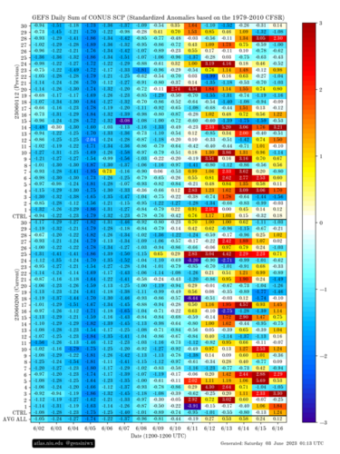
The signal is very noisy, but it appears that, starting about a week from now, there are substantial indications of increased severe environments in the US.

That's why I asked for the week of June 12-16 off, last week. I was fretting a bit in the discord yesterday about the operational CFS and GFS seeming to drop it for a few runs; but the ensemble signal is still there. (Latest op CFS still drops it, cuts the trough off out west and doesn't actually eject it across the Plains until the following week, after Father's Day!)

I gotta remember even though it feels like I've already been watching that period for ages, it's still nearly 300 hours out. I just commented in there, it'd be more worrisome if it were showing a perfect, classic negatively titled trough ejection at this range.

As my wife says "woo-sah."
 
I've only been following the synoptic pattern closely for roughly a year now, but for the life of me, can not remember a spring with such cool nighttime temps as this one on the east coast. It got down to a low of 36° about a week ago, and has averaged high 40s and low 50s consistently, which kinda blows my mind since we're into June now. Moisture has been completely absent up until a few days ago, which is enjoyable as far as comfort goes, but has only aided in the spread of some wildfires and the associated haze.

I was kinda hoping the parade of lows and troughing on the east coast would at least bring some garden variety storms to the region, but I'm still waiting. The long range models have been hinting towards the action picking up around the 9th in my area, which ties into the chart @Jeff Duda posted... but I feel for everyone out on the Plains. Chasecationers are getting a raw deal unless the were fortunate enough to book trips after the climatological peak. Again, my opinion could very well be biased based on my recent introduction to following the weather closely, but it's interesting nonetheless.

When was the last time some of you veterans saw a similar pattern play out through the main part of spring?
 
I gotta remember even though it feels like I've already been watching that period for ages, it's still nearly 300 hours out. I just commented in there, it'd be more worrisome if it were showing a perfect, classic negatively titled trough ejection at this range.
My thoughts exactly... At this point I'd be surprised if ~something~ didn't materialize in that time frame... The signal is certainly there and the GFS picks up on it, despite CFS recently wavering. The question is "only" what and where 😂

Don't want to get my hopes up too high, but I'm suffering from acute storm deprivation syndrome here in California... probably going to head out in a week. I'll be happy few marginal-to-slight-risk-type-days, and more robust setups would be bonus.
 
Even though I am still booked for 10-16, I'm gonna make the final call this coming Tues/Wed. The 00Z GFS this morning is interesting for sure on that Negative tilt on the 12-14th. I think if the trends between now and then remain either positive or negative, that's enough time in terms of real model trend confidence that I, for me, can make a good determination on saving the money and cutting off this seasons run out there or not. woo-sah indeed lol
 

Attachments

  • 240hr 500mb.png
    240hr 500mb.png
    748.2 KB · Views: 0
When was the last time some of you veterans saw a similar pattern play out through the main part of spring?

I think the better question is, when was the last time it was a *good* pattern. I feel like it’s been poor for 10+ years already. Last active season I remember was 2013, and many didn’t even like *that* one because the activity was condensed into just two weeks - but oh what a two weeks it was!!!
 
Glad to see the thread is still alive and active. I haven't had much time between work and taking some R&R time away from chasing.

  1. May forecast was an obvious bust and 2 category error with one of the lowest May tornado counts in decades. 7 states recorded no LSRs in the month of May which is incredible and not something seen since the 1950s. This will probably be an interesting case study on predictability, but it definitely says that we have a long way to go for sub-seasonal forecasting.
  2. The good news is the rain. Climate models have been correct about the above average precip across much of the High Plains and it looks like this will continue. Hopefully, we can nix the drought completely.
  3. Hello June! 👀 
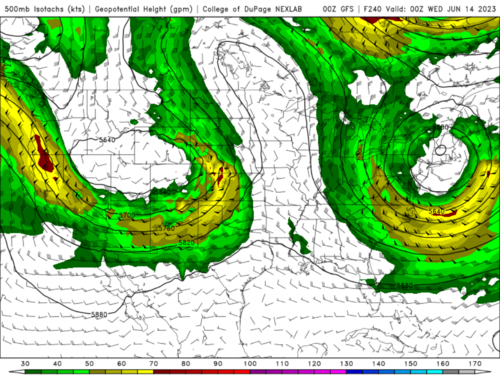
Also not something the southern and central Plains have seen for several years, the pattern heading into mid to late June appears much more favorable for severe over a broad area. With the height gradients finally tightening from the fashionably late sub-tropical ridge and continued western US troughing, significant flow aloft looks very likely. With near climo moisture and the drought help out west, EML concerns arent nearly as high as typical in June. Some really strong indications of better flow and an active sub-tropical jet look good for some nice late spring and early summer chasing activities.
1685894314431.png
 
Status
Not open for further replies.
Back
Top