State of the Chase Season 2021

Status
Not open for further replies.
Yeah that signal for the MJO to begin progressing across the Indian Ocean late this month into the first half of May is growing across all guidance, including bias corrected options. The current state favors eastern troughing and a generally cool pattern in spring (which is what we're seeing), but as can be seen in that North Pacific Phase diagram plot above, there is a growing signal for a cycle through an equatorward shift and jet extension towards the end of the month, which has been a precursor to extended periods of AA activity in the past. The addition of a recurving TC in the West Pacific adds another layer to this, which may provide a boost in westerly momentum across the Pacific.

The longevity of said AA period is still TBD, but seems to me that some interesting is coming here.

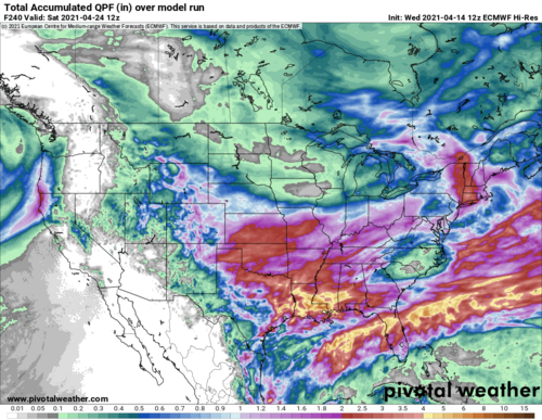
On top of the tropical forcing becoming more interesting, it seems this down period will not be completely fruitless, as medium range guidance consistently indicates widespread precip across the southern/central Plains thanks to embedded shortwaves in the southern stream, not overly dissimilar to what happened yesterday evening/overnight across Oklahoma. E.g. is the 12z ECMWF accumulated QPF output at FH 120 and 240 (half the period and the full period).

1618428391039.png
1618428328409.png
 
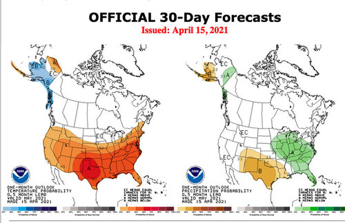
I don't put a lot of stock into these outlooks. The outlook for February was a bust, and April has been much cooler than what has been forecast. I had my yearly "the season is going to be trash" meltdown last week. This week I am much more optimistic going into May. There are continuous signs at a transition in the MJO with an 8-2-1 progression possible by the beginning of May. Still a lot of uncertainty as to how things play out, however it's not looking nearly as bleak as even a week ago. 🤞
 
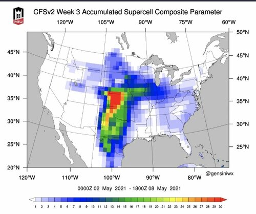
You know , lets just say for a moment that their forecast pans out and that's the average pattern trough May. what that picture tells me is that the intersection of the temp trough from South Dakota, Ern NE, through Iowa and into Illinois intersects with the NW corner portion of their Moisture field area, it tells me that's where to look for possible good things. that's me just trying to see through the negative lol.
 
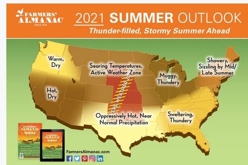
There is enough future weather research being done by members here. I cant really add to it..and probably not smart enough to. So.. i did a little "alternative research" that brings some joy .( Mods move this if you feel the need) That being said..My great grandma always said " if you really want to know future weather, just go to the Old Farmers Almanac ;)weather2021.JPG


According to the extended forecast in the 2021 Farmers’ Almanac, summer should be stormy, with a greater-than-average frequency of thunderstorms for a large portion of the country. Many of these storms will be strong, particularly over the eastern third of the nation. These summer rainstorms may be severe and spawn widespread tornadoes over the middle part of the country during June and July.


Portions of the Central and Southern Rockies and Great Plains could also experience higher-than-normal thunderstorm activity.


May 2021 Long Range Weather Forecast for High Plains

DatesWeather Conditions
May 1-6Showers, turning warm
May 7-12Scattered t-storms; warm north, cool south
May 13-19Scattered t-storms, cool
May 20-31Isolated t-storms; hot north, cool south
Maytemperature 58.5° (3° above avg. north, 2° below south)
precipitation 2" (0.5" below avg.)

NOW WHO COULD ARGUE AGAINST THEIR GREAT GRANDMA?
 
Last edited:
Subex height.jpg

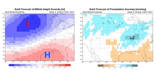
So its appearing more and more that the MJO is going to cross from Phase 7 to 8 over the next couple weeks, and seeing this SubX anomaly certainly isn't a terrible picture for May.
 
@Jason N. I sure hope that pans out to some extent. I wish it would recede farther north and west, since I live in eastern Nebraska, and a pattern like that would push systems to far south and east. I hope I am wrong about that though.
 
As the first of May comes within reach of the ECMWF ensembles it looks to me like there is going to be a zonal flow pattern over the Great Plains with a ridge in the Atlantic stalling a trough over the east coast. A lot can change, but this general pattern has been fairly consistent for the time period 300-384 hours out.
 
Seeing some extremly encouraging signs across the board on the last few runs of both the determenistic memebers and ensembles for the development of the westerly jet extension. We are within 10 days of development now on the GEFS which starts to show considerable predictability. These large westerly jet extensions are inherently unstable and decay into smaller "packets" of energy we know as shortwaves. Think laminar flow like from your garden hose and how after a certain distance it becomes trubulent. The same thing should happen here as westerly momentum is redistributed across the hemisphere. All things considered, this is looking like the first few weeks of May will be AA with moderate confidence.

Whats more interesting is the potential placement. As we all know the drought across the west has been worrisome. That is reflected within the GEFS as higher than average heights across the southwest owing to warmer temperatures less precip and greater diabatic effects. This may subtely influence the breakdown of the westerly jet and western US troughing by keeping it a bit more zonal and farther north on average. That may put the northern half of the southern Plains and the central Plains in the bullseye. Assuming the pattern holds, I think we are talking a big year for Kansas and possibly Nebraska.
1618723831046.png
 
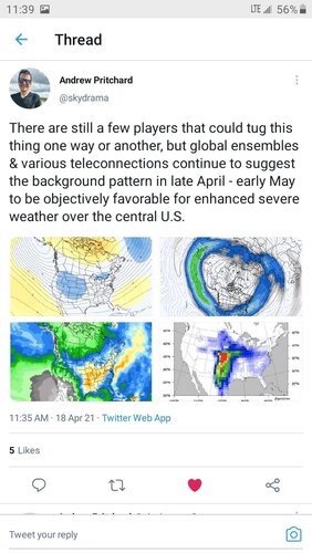
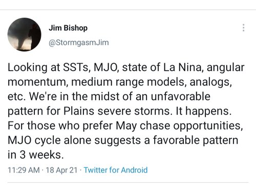
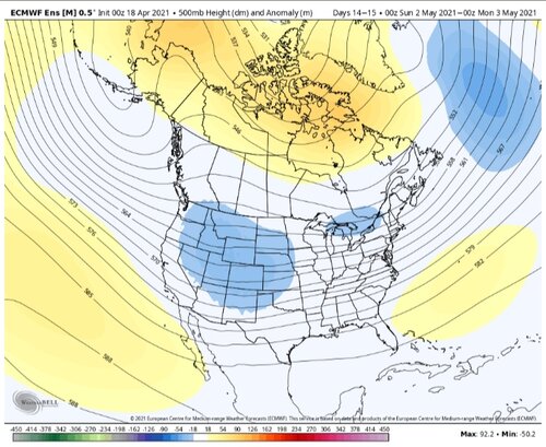
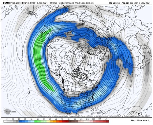
Seeing a number of tweets about a coming pattern change favorable for severe weather across the central U.S. by early May.

Screenshot_20210418-113938_Twitter.jpg20210418_114207.jpg20210418_114137.jpg20210418_114120.jpg20210418_114053.jpg20210418_114034.jpg
All of this is encouraging. Perhaps we end up with a solid run of chases in May. I prefer a back loaded season. Hope June is active as well since I will have plenty of flexibility to chase then.
 
Jim is an excellent energy meteorologist. Of course we use those tools for personal severe wx season off peak temperature seasons, haha.

Sorry to all who replied to or tagged me over the last week. I think this is my first visit back since my post. In what may be more luck than skill, my May thoughts are not yet derailed. Too early to say I'll be right though.

First of all a section of Dixie (TBD) may get severe one day between Fri-Sun, Apr. 23-25, inclusive. While of little interest to the Plains, it's a start.

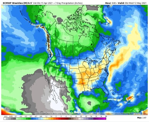
Next the mid-range models (GFS/EC) continue a doable pattern in the 11-15 day period. Trending away from a West ridge and more just Southwest or south-central. However the East still wants to trough at times. Still a zonal flow across the Plains at least opens the door.

Finally the long-range weeklies (CFS/Euro) are less hostile in May. GFS weekly version is being the GFS. I really would not want to see an ideal pattern weeks 3-4 (very fickle). Simply not bad is good. Then when something looks good week 2 with ensemble support, start thinking about travel and/or making arrangements.

Above assumes a flexible chasecation or floating time off request. In the Plains, just be patient. It's coming.
 
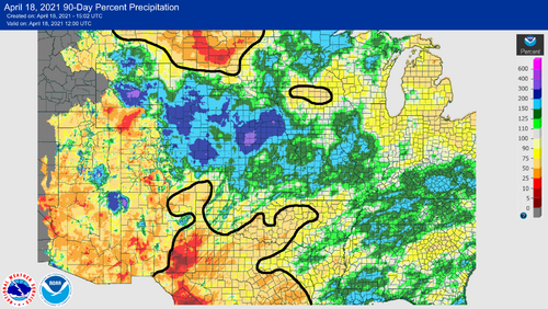
Been trying to keep my mouth shut of late - you know, nothing nice to say and all that. There's simply no upside to the dominant early spring pattern that seems to be the new normal in our part of the hemisphere. No storms, spring activities disrupted by extended arctic blasts, and below average precip incurring us evapotranspirational debt for the prime season, should it ever arrive. It's just plain miserable, but after almost a decade, I suppose we need to set it as our baseline expectation until we start to see counterexamples again.

With that said, thank the heavens for that quirky wet period in mid-late March! At this point, it may be the only silver lining holding off the depression meter from pegging the red line (well, aside from 2-4 week speculation that was similarly heightened for this current period, during which OKC will probably average daily maxes ~15 F below normal over a 10-day stretch).

Attached is the 90-day running fraction of normal QPE. I've crudely contoured relevant areas of concern (<75% of normal), revealing a bifurcated Plains with big problems both S and N, but safely drenched in between. I flipped through Palmer Drought Index plots from 1950-present this evening and couldn't really find any other good example of a comparable drought situation going into May; so this is fascinating, if nothing else. If drought worsens and expands over OK/TX, I'd have some concern about mild secondary impacts downstream in KS and CO, even with favorable local transpiration there. That aside, it's becoming clear that KS/NE will likely offer the most fertile ground for subtle, ET-aided setups this spring, unless we see an extremely wet pattern emerge elsewhere by early-mid May. Shall we all start pitching in for a chaser compound in Hays?

20210418.png
 
SPC in with a Day 5 (Friday) risk area over portions of the Southern Plains.

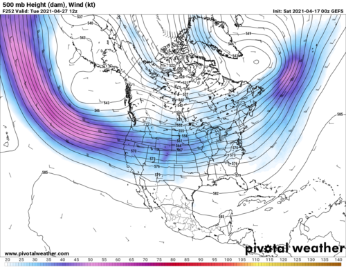
Additionally, GFS has become somewhat consistent with a rather gorgeous 500mb pattern for at least a couple of days in the last week of April. However, it has also been consistent with very strong CIN over much of the would-be target area. It also seems to want to sweep the trough out quickly returning low heights and chilly conditions to the East, rather than holding it back over the West spitting out shortwaves over the central US, which would be the ideal pattern for an extended period of chase opportunities.
 
Last edited:
Update: Overnight 06Z GFS run is perhaps the most intriguing yet for the 4/27-4/29 timeframe, verbatim would be a potential chase day and possible significant outbreak from MBY (where an eye-opening 80kts+ of bulk shear is progged) to the Southern Plains. Euro also has a large trough in the central US in this general timeframe, but 19/00Z run is a little faster with it than the GFS and more amped, with rather meridional 500mb flow.
 
Status
Not open for further replies.
Back
Top