State of the Chase Season 2021

Status
Not open for further replies.
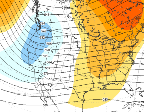
Here is the EPS 11-15 day. Not for commercial use. At any rate it's working on a West trough. Even if the 6-10 day attempts can't draw Gulf moisture, the 11-15 day should be able to do so.

Beginning of the 11-15 day period is still Plains ridge. This is the period average. By Day 15 the trough digs into the Rockies with East US ridge. Keep in mind it's 50 members so that's a good composite with agreement amongst the clusters.

Rest up my friends. More is coming!
1617038821333.png
 
I've been seeing that La Nina SST's are warming pretty quickly in the last month and is forecast to be ENSO Neutral in the next Several Weeks , well the 60% chance. but it reminded me about teleconnections and phases, and I've read some papers on tornadic occurrence with regard to La Nina strength and duration, or returning to Weak or Neutral El Nino conditions. ( I am most specifically referencing the Barbara Mayes NOAA/NWS Paper: Tornado and Severe Weather Climatology and Predictability by ENSO Phase in the North Central U.S.), I thought I would attach the paper for those interested.
 

Attachments

Some value is gained in the Upper Midwest per the paper above.

For the Southern Plains and Southeast the TNI Trans Nino Index is also important. It has four phases. Resurgent La Nina is bullish. Like the name says, La Nina bounces back in spring (not happening this year). +TNI may happen, where region 3.4 hangs on cool while 1&2 SSTs warm AN. +TNI is also bullish.

Bearish phases match above research. El Nino not so much action. Fourth phase is more -TNI and also bearish. Can't find the TNI papers. They are on my retired work PC. Big mistake, lol!

Anyway my April forecast reasoning has not changed much. Could be a quiet period following the strong cold front this week and Plains ridge next week. New West trough is forecast the third week.

Questions remain on AO type broad blocking. However if Alaska is OK a -NAO can combine with +ABNA to yield trough West ridge East. That's shown in some 11-15 Day ensembles. See if the trough can work into the Rockies; but, that's just beyond the end of the forecast period.
 
Jeff, I have this one presentation on the TNI and Tornadic formation From Sang Lee, which I will also drop here. I thought it to be pretty interesting in how it tied into the ENSO phases . so it might be worth a look to see what the TNI numbers will be and see if some type of loose verification emerges? maybe too lofty or speculative, but interesting all the same. I specifically was drawn to his assertion that many of the largest outbreaks occurred during La Nina decay years - 74', 99', 08' & 11 , but would this current La Nina expecting to go neutral, is that really considered a decay the way he thinks of it? I'm not sure.
 

Attachments

Medium and long range models are not depicting any signs of life for chase-worthy prospects in the Plains anytime soon. La Nina appears to be quickly fading, the ongoing drought appears as though it will get worse, and persistent troughing over the eastern/northeastern U.S. all appear to be negating factors for robust severe weather anytime soon. I know it's only early April, but my hopes for a solid chase season aren't very high going forward. Maybe 2022 will be different. If we end up with two trash years in a row, the desperation of storm chasers in 2022 will be unparalleled.
 
Medium and long range models are not depicting any signs of life for chase-worthy prospects in the Plains anytime soon. La Nina appears to be quickly fading, the ongoing drought appears as though it will get worse, and persistent troughing over the eastern/northeastern U.S. all appear to be negating factors for robust severe weather anytime soon. I know it's only early April, but my hopes for a solid chase season aren't very high going forward. Maybe 2022 will be different. If we end up with two trash years in a row, the desperation of storm chasers in 2022 will be unparalleled.

Come, now. It is only the beginning of April - the very beginning of the three peak months of the classical season. A lot can happen, and most of this period is beyond what we can reasonably forecast at this time. April is always a boom-or-bust month. Still a lot of polar air masses hanging around parts of tornado alley to screw with setups.

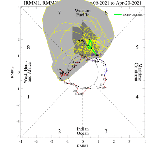
I took a look at the recent MJO parameters and...well...the quiet period lately makes sense. The MJO cycled through phases 3-4-5 over the past 10 days, which, IIRC, is the most unfavorable part of the cycle for NA severe weather. The latest forecasts show the MJO dramatically intensifying and sitting in phases 6/7...not sure if that is good news or bad news (closer to a node in the cycle rather than an anti-node), but it looks anomalous either way.

However, should this happen and then the cycle continues into the 8-1-2 phase...hooooo boy could we be looking at an active period towards the end of April! This is speculative, however.

ensplume_full.gif
 
Thank you @Jason N that is indeed the paper! Easier to grab it here again than dig around my office PC by remote desktop, haha.

Wow my last forecast post (with the chart) aged poorly. However I do agree that the weather pattern will come around. MJO will eventually exit dreadful phases. Little westerly wind burst is a debacle. Atmosphere may resume a La Nina-ish imprint even as SSTs ease, barring a brutally long westerly wind anomaly. If all else fails, put some hope in +TNI.

In somewhat less reliable forecast news, the CFS wants to go back to La Nina next winter after this easing. While I don't put any stock in that, it would make La Nina resurgent.

One thing about 2021 so far, Dixie has shared with the Plains early season. As I type Kansas is blowing up. Hope it bodes well for peak Plains season (open fields only).
 
Jeff -- No problem!, I thought it was interesting and looking at the PSL dashboard, and well, I think we can all probably agree it's still a little bit early to tell, still a lot of considerations over the next month or month and a half, as there is a +/- 3 to 4 week delta from the time the Nina/Nino SST changes occur to when we see effects starting to happen on other systems? and the SST's have only recently(past 2-3 weeks?) started to warm a bit, so I think we have some time to see how things will adjust in terms of the Teleconnections of the MJO/NAO/PNA and AO and their associated stronger or weaker responses to those SST changes. perhaps by late April-very early May? -- again, just a guess on my part.

(fyi - I'm still a bit new to this dashboard in here, so I couldn't find the "mention you" specifically. typing @JeffHouse -- didn't work. lol )
 
Looks like some weird stuff on the CFS, similar to last year. It's obviously way out in fantasy land but the trend is still a bit troubling. Looks like split flow, then when we finally get some troughing out west, the jet streak magically disappears across the plains. It looks like the CFS wants to form a tropical storm towards the end of the range too...in the beginning of May :rolleyes:. Similar to last year, there just seems to be something off with the jet stream. Having said that, this is all based on the CFS and looking out 798 hours into the future.
 
Yeah one cannot really sugar coat the rest of April. Weeklies do break down the super blocking and displaced Hudson Bay low in May. No particularly interesting pattern is shown, but it's better; plus, it's still 4 weeks out.

Three weeks ago a big West trough was advertised. Instead we get this debacle with the Hudson By low dropping south. Three weeks ago had some -NAO risk, but the forecast +ANBA busted. The -ABNA with blocking is game over at least for a couple weeks. Interesting we had a mid-April cool snap last year too.

That said I'm still optimistic about May. Weeklies are ensembles of 50 members; so, I would not expect anything classic to show up 4-6 weeks out. In fact I'd rather see it 2-3 weeks out than weeks 4-6. Last year a good May pattern showed 3-4 weeks out; then, got destroyed by small scale closed lows.

I have no reason to forecast that again this year in May. Despite fading La Nina SSTs, if the atmospheric imprint holds it's less conducive to closed lows. However if this MJO mess continues and/or on more westerly winds down there, that could squash any Nina echo.

I feel for my Plains friends (real-life and on here) April; but, there's no reason to worry about May. If March is pre-season, April and May regular season, and June post-season for those willing to travel, it's early.

Yes @Jason N this year might decay a little faster than those you note. If the imprint can just hold on to May. Oh to tag/mention someone, just start with first name and wait for the drop-down a couple seconds. Space between names loses it. I usually tag if I'm a few posts later or several days later. I saw your reply well. Good stuff!
 
Yes I refer to all Weeklies (average blend) if I do not specify. On the very broadest themes, all three generally agree. Dreadful the rest of April, yields open doors right around May 1 forward. All three is the ECMWF CFS and the GFS also has a weekly product - which will eventually replace the CFS I believe. Don't laugh it's actually a decent weekly product, given that all weekly products are taken with a grain of salt.

ECMWF is slowest to come around for May; however, it's had issues with the week 3 pattern getting stuck for weeks 4-6 for a couple years now. Anecdotal, from an energy/temperature perspective, and not statistically verified. CFS/GFS weekly both have a better pattern in May. It's not classic deep blue Rockies trough. However it shows energy coming through the West with QPF in the Plains. It's a start!

MJO remains an absolute debacle. Convection is in unfavorable areas. JTWC actually has an Invest east of the Philippines which is such an awful area (for our chasing) driven partly by an unfavorable westerly wind burst. My hope is that even if it does not develop, it'll use up some of that energy. Gonna need a reset from the Indian Ocean to Martine Continent for chasing.

At least the American weekly products show a bi-modal MJO. If we can get Maritime Continent to dominate it'll be fine. Time will tell. However the season is early; plus, MJO and weekly forecasts are statistically worthless past week 3. Continue Tee Up May mode.
 
I'm still going with Accux-WX and their PhD's prediction of a great chase season. Seriously, I'm not liking the RH distribution or upper air patterns for the near future, especially given they are beginning to look like last year, to some degree. Lots of zonal and NW flow over the Central Plains if you follow the NCEP Ensembles. Not ready to write off May or early June as it's too far out and eastern CO is always a wild card. Might be another great hurricane season, so all is not lost.
 
The next couple weeks look about as boring as anything I've seen for storm chasing. Pretty glad I got on the bandwagon early this year on March 13th in Texas...starting to wonder if we will even get local setups here this April (aside from some low end severe storms we had on Wednesday which featured a July-like mushy shelf cloud).

Today featured more heavy rainfall, northerly winds gusting over 40 mph, and highs in the 40s with wind chills in the 30s (more typical of early March than April here). Hopefully May can come in clutch with a series of 2013/2016 style setups to make up for this miserable pattern we are in.
 
Status
Not open for further replies.
Back
Top