State of the Chase Season 2021

Status
Not open for further replies.
I am no longer connected to AccuWeather. With that stipulated, I don't like anyone's >30day outlooks. No consistent skill has been demonstrated.

But, if you are going to criticize AW, what about the NWS making specific daily forecasts of severe weather? https://www.spc.noaa.gov/exper/CFS_Dashboard/n Shouldn't you also criticize them?

Somewhere along in this forum is me discussing how useless the CFS chiclet charts displayed on SPC are for predicting severe weather.

Also, that chiclet chart isn't predicting tornado counts...it's reporting the number of grid points at which SCP > 1 from the GEFS...that's it. It makes no promise that these numbers translate to above or below normal tornadoes (there is no "normal" even indicated on the charts). AccuWeather, on the other hand, tries to declare (1) tornado counts (2) above or below normal, two very specific quantities that are not featured on the CFS chiclet chart.
 
Back onto the drought situation, also note the dry line may want to mix east faster and farther than progged some days. By late spring the drought and jet stream can get more correlated; and, there may be some causation (both directions).

Regardless of the chiclets, if one can infer southwest flow over the Plains in the weekly charts, then it's all good. Trough West/Rockies SER east. Early season Dixie push all that east, Plains to Mississippi Valley trough and more suppressed SER mainly right on the SE Coast. It's nice when QPF makes sense too. Chiclets can cross-check late season when the above analysis is more diffuse. Early season, just look at the weekly charts.

In all cases, remember accuracy degrades past Day 10. Keep to broad themes weeks 2-3. No comment weeks 4-6.

Finally, for mid-March I still see opportunity after the first one or two systems. I'm thinking after the time change March 14. First couple systems either lack moisture, go north, or go positive tilt. After the time change (convenient) could be better set-ups.
 
Hi Jeff,

I'm aware of what the chiclets forecast. However, if you click on the chiclet, you see a map of locations of severe thunderstorms, including possibly tornadoes, out to 45 days into the future.

If you apply the same logic to both, AW's forecasts of the severe weather/tornado season as a whole, is a far less egregious stretch of forecasting ability than trying to draw isolines around local severe wx maxes out to 45 days.

Note: I do not show any forecasts beyond 30 days on my blog nor do I share them on Twitter. I don't believe any of these demonstrate consistent skill.

Best wishes,
Mike

Somewhere along in this forum is me discussing how useless the CFS chiclet charts displayed on SPC are for predicting severe weather.

Also, that chiclet chart isn't predicting tornado counts...it's reporting the number of grid points at which SCP > 1 from the GEFS...that's it. It makes no promise that these numbers translate to above or below normal tornadoes (there is no "normal" even indicated on the charts). AccuWeather, on the other hand, tries to declare (1) tornado counts (2) above or below normal, two very specific quantities that are not featured on the CFS chiclet chart.
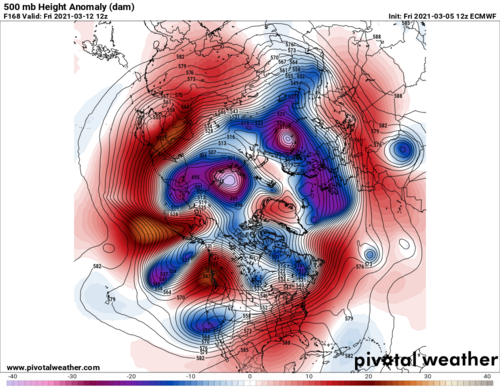
 
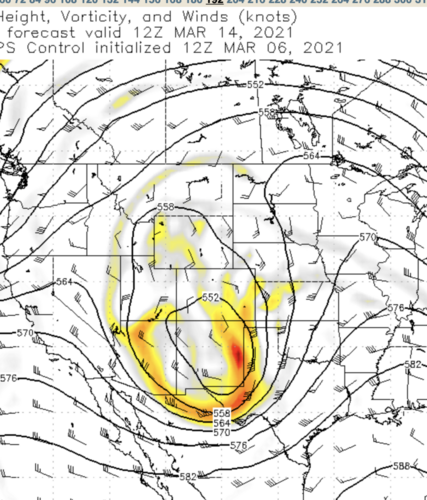
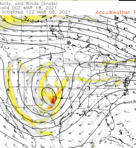
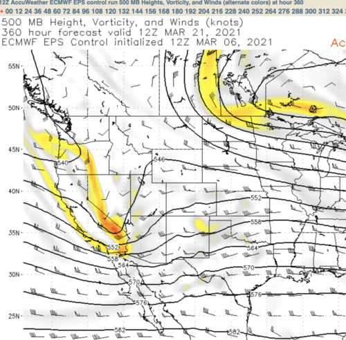
While I certainly would prefer if the ECMWF depicted faster open-wave systems, these two vigorous, negative-tilted lows combined with a digging, negatively-tilted trough at Day 15, doesn't look like a bad start to me. Combine those with 140+knot winds over the central U.S. and I think we'll see some action. The circulations with the first two systems has sufficient meridional flow over the west Gulf to bring the moisture the moisture north.
 

Attachments

  • Screen Shot 2021-03-06 at 5.14.36 PM.png
    Screen Shot 2021-03-06 at 5.14.36 PM.png
    762.8 KB · Views: 0
  • Screen Shot 2021-03-06 at 5.14.49 PM.png
    Screen Shot 2021-03-06 at 5.14.49 PM.png
    893 KB · Views: 0
  • Screen Shot 2021-03-06 at 5.15.00 PM.png
    Screen Shot 2021-03-06 at 5.15.00 PM.png
    879.7 KB · Views: 0
La Nina really can go either way, especially as it tends to promote drought over the southwest and thus strong EMLs. Perhaps the technical discussion is better left to the "state of the season" thread, but lately the signs sure have been pointing more in the direction of another "dud" Nina season.
 
Well, the Southern Plains have three days of potential coming up late this week into the coming weekend per SPC. Details such as timing, location and magnitude of greatest threat; storm mode, and overall chase quality all TBD. It's early, so my expectations wouldn't be too high, but at the very least could be a good shake-the-rust-off chase for those based in/near the risk area, especially since it's a weekend. Besides, recent years have shown that the old "wait for May" mantra doesn't always work anymore, so if a chaser has the finances/schedule flexibility to do so, he/she should be prepared to jump on early/out-of-season opportunities should they present themselves.

*Note I haven't personally looked at any models for this potential event yet, since it's out of my range and the last several years have indicated to me that it's pointless for anything beyond entertainment to look at models more than 4, maybe even 3 days in advance when you're trying to nail down details on things such as tornado potential; winter storm precip types and amounts; or TC track/intensity. Being a hobbyist rather than a professional, I have that luxury.
 
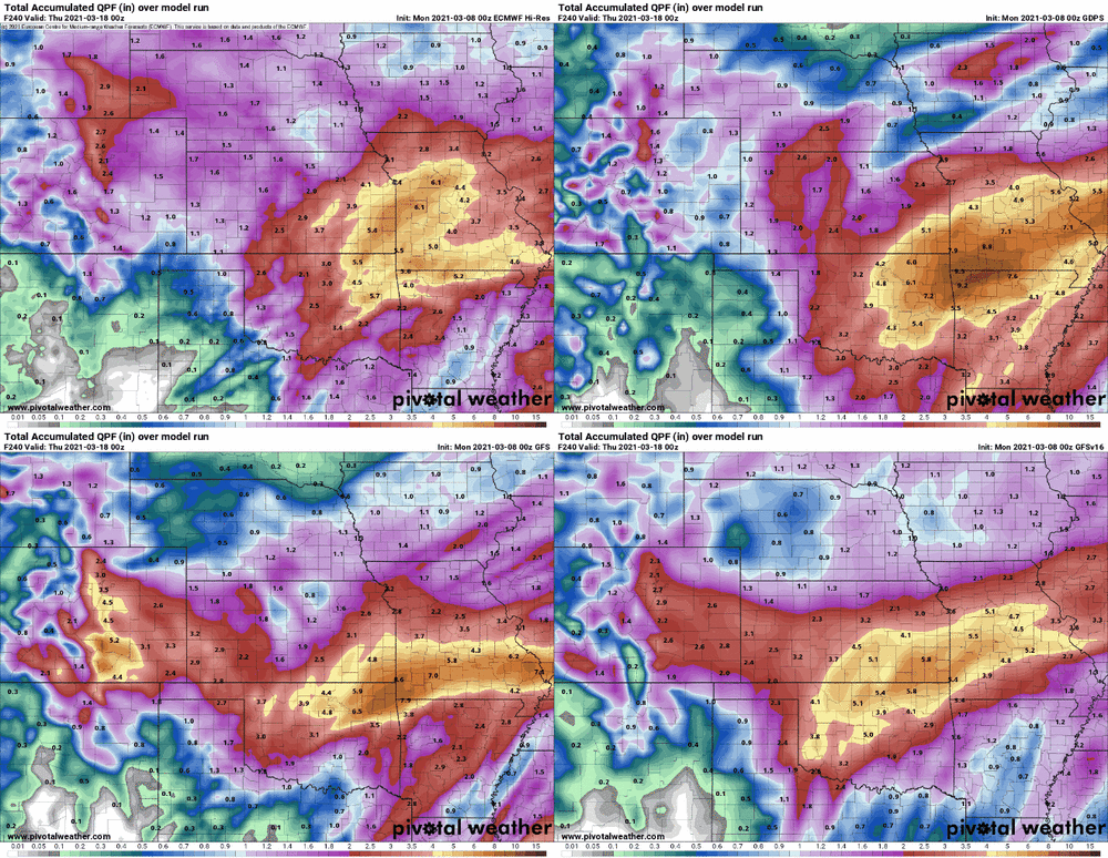
Above all else, I'd like to lock in current progs for a deep and slow-moving cutoff by late week. Some of these QPFs would be a godsend for southern Plains chasing over the next couple months, provided any favorable setups materialize. There's currently strong agreement over much of OK and S KS for totals that could really mitigate short-term drought through at least April, with extension back onto the adjacent High Plains less certain. I'm waiting for the rug to get pulled out over the course of the week because this would be very un-Nina-like. But since this entire cold season has been that way (and watch us get robbed of the active mid-spring jet that Nina is more often associated with), maybe we catch a break here?

models-2021030800-f240.qpf_acc.us_c.gif
 
Split flow will be great for snow lovers in the Upper Midwest this weekend, put some cold air in place. While far from ideal Southern Plains, we'll see how stout the southern stream behaves.

Split flow is definitely an issue early season. It's less of an impact late season, unless untimely. Once the moisture is in place (perhaps east due to drought) and southwest flow establishes in May, good things can happen. At least systems have been coming through. I would not let a couple March debacles discourage; however, one would want to see April behave better.

Then May does May however it wants, and sometimes mesoscale makes or breaks. Oh yeah @Mike Smith the daily chiclets charts are about as valuable as most NCAA brackets by late March, lol!
 
This weekend's system has definitely helped improve the drought situation across the southern and central high plains. Better to have a drought in the cool season than in late spring. While chasing in the Texas panhandle this past Friday and Saturday I noticed that the area didn't have the appearance of being in a severe drought. Vegetation was just starting to green up.

There has been a lot of talk about tornado activity being focused east of the plains this year, however that has yet to be the case. Perhaps we continue to see more activity over the preferred regions of the traditional alley moving forward deeper into spring.
 
Status
Not open for further replies.
Back
Top