State of the Chase Season 2021

Status
Not open for further replies.
Joined
Apr 10, 2008
Messages
533
Location
Tulsa, OK
Yes, I know it's just a few days into the New Year and we still have a couple of months to go before we get into spring, however I couldn't help but get this thread started. Maybe because of COVID and how abysmal 2020 was from a chasing standpoint, I find myself extra eager to get out this year, and am counting down the days (75) until spring.

I am looking forward to waking up on those spring mornings when the south wind is ushering in the tropical moisture from the gulf and supercells are in the forecast.

While it is still early for the seasonal tornado outlook forecasts, I am curious if there are any early thoughts on the overall global patterns (ENSO, MJO, NAO, PDO, etc) and how they may line up going into spring.

Last year was pretty lame for tornado activity in the traditional tornado alley with states like Kansas having very little action at all. It's hard to imagine this year being as bad as 2020, but nothing is a guarantee.

Would love to hear your thoughts.
 
Staff note

Since a separate thread (in the same sub-forum: COVID 19 and the 2021 Chase Season) exists to discuss the impacts of the COVID-19 pandemic on chasing, this thread should remain strictly limited to the meteorological aspects of the 2021 chase season. Any comments regarding COVID-19 should be left to the other thread.

If it becomes clear later on that the two topics cannot remain separate, we will merge the threads, but for now, talk of COVID-19 in this thread will be deleted by moderators.
 
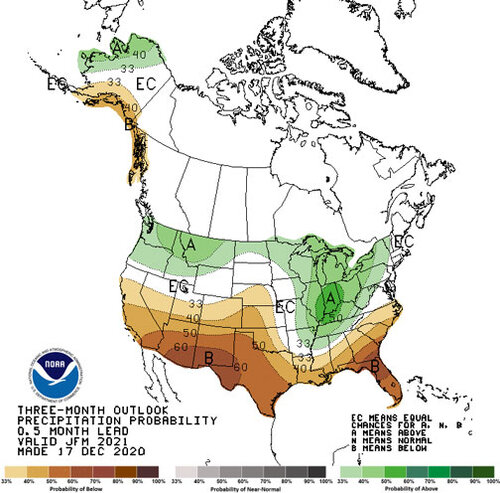
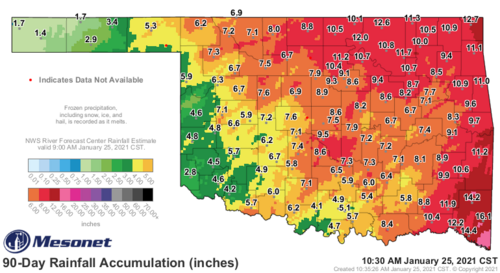
I will say for starters that I am pleased by the amount of winter precip many areas of the Plains have received thus far given the encroaching drought. The storm last week dumped a pretty wide swath of 1.5-2”+ QPF including areas like the Trans-Pecos and Central TX that very much needed it. NW OK and SW KS have also were repeatedly hit with snow storms in December. Keep that kind of idea up to at least some degree through JFM and we may have less concerns in terms of excess mixing of low level moisture.

I think it’s safe to say that we are liable to see an enhanced EML this year given the drought over the source regions in the SW, but I’d rather that then having moisture getting mixed out near the dryline like what happened in years such as 2014.
 
I usually wait a few more weeks to settle in on my analogs but they are coming into focus now.

If we assume some persistence and eat what climate ensembles are cooking, the next 2 months will appear something like this:

-PDO
-AO
-NAO
-PNA (or neutral)
-ONI

This year's winter season presents a unique challenge. While this is a "First year Nina" , there aren't that many examples where severe to extreme drought was noted over the high plains and EML source region. Past examples include 1989 and 1955. Two very different outcomes. However, 1989 also featured huge +AO and +NAO in winter making it a not-very-good analog, Which makes 1955 quite possibly the closest analog we have when factoring in Drought. Unfortunately we don't live in the same climate as 1955. 1955 would be an A-tier chase year in the modern era.

However drought impacts appear to be in flux. Recent systems have solved soil moisture issues in places like the Trans Pecos region, while long range forecasts appear to be favorable to either not worsen the drought on the high plains, on up to possibly eliminating it (unlikely)

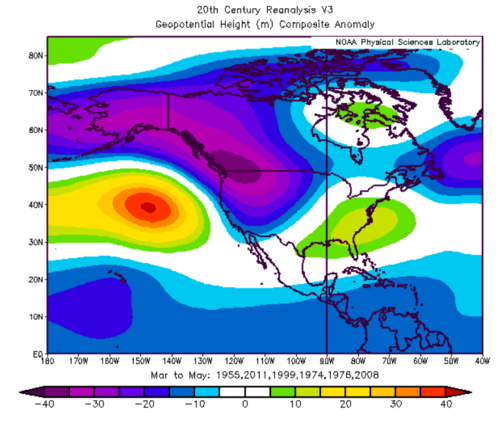
As such, additional analog years could be introduced such as 2011, 2008, 1999, 1976, and 1974. I may be missing a few so don't assume this is complete.

HOWEVER before getting too excited--All of these were stronger Nina's than this one. The good news is, all other teleconnections at least appear at this time to be following that of these stronger and more recent Nina's. Older analogs going back to early century featured what would have likely been boring years for tornado chasing.

Yes, that would be quite lit. However this depends on maintaining a Royal Flush of (-) teleconnections and our drought not worsening or Nina deciding to take an early spring break.

Analogs are FAR from perfect. For example, I had 2020 being a repeat of 1990. While climatologically it was 1990 almost spot on, the storm systems we got experienced Murphy's Law in the extreme and also it was 2020.

Personally I would rather see a 1955/2008 season above all others in that list. Who wouldn't.

So to make a hail mary pass that I can come back and laugh at this May.

Dixie = Highest possible Ceiling. Likely a destructive year for at least some. (what else is new)
Plains = Concentrated on the I35 corridor and east. Probably below average season count wise. Unless we 2008/1955 somehow.
High Plains = Drought/EML dependent, but probably won't matter as synoptic systems likely bypass the high plains for most of the season until peak. Based on Analogs, the high plains are largely skipped.
 
Overall I am encouraged by what I am seeing so far in 2021. Models show trough after trough into the southern plains. Moisture return is a problem -- but that is supposed to happen this time of year. It seems like in 2020, I could look at upper air and just stop looking after that (and that was year almost).
 
I think the drought will continue to influence Plains weather for the immediate future, or at least the western regions. No snow on the 9k ft. Arizona mountain peaks visible outside my office window this time of year is not a good sign -- based on past experiences. I would **guess** there will be more opportunities this year compared to last year by a shear roll of the dice, given it's hard to imagine an even worse chase season. If the Canadian border is open during late May and June+, I'd expect to see a lot of chasers heading north to the new promise land.

If we go into a National lock down, then it does not matter, although I would go out regardless because it's in my nature.

off01_prcp.jpg
 
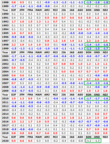
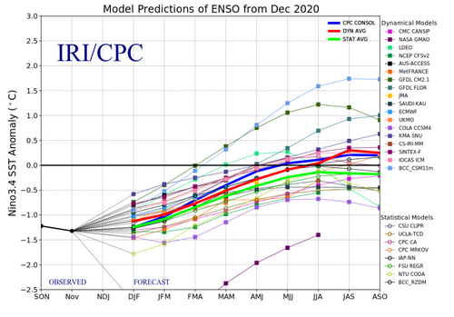
Time-averaged SSTAs over the Nino 3.4 region have reached cold values we haven't seen since the winter of 2010-11. From an ENSO perspective, this puts the current cold season in rare company the past few decades. Spring seasons following full-blown Nina conditions of this magnitude include: 1989, 1999, 2000, 2008, and 2011. On the bright side, several of those were active and featured outbreaks, even if they lean toward drought and focus on the eastern side of chase alley. Spring 2000 was pretty bad, but still better than 2 of the past 3 years. However, the current weekly Nino 3.4 SSTA of -0.8°C is a fair bit milder than any of the years listed above, and the average of model forecasts still indicates warming to near neutral by the AMJ average. That would suggest an ENSO evolution more similar to the likes of 2006, 2009, 2012, and 2018 by springtime, and I don't need to tell anyone here how to feel about that.

At this point, I think it's still a fairly easy call to bet against lush vegetation on the High Plains and lots of successful finesse setups from Childress-Hays and west, but otherwise mixed signals abound. It strikes me that our early seasons have been overwhelmingly duds lately, but quite a few of the cool ENSO years above got active early (of course, active in April does not necessarily mean great chase days, even if it's active on the Plains). Maybe something to hedge toward changing this year, relative to recent times. Of course, that would require an early spring pattern without the unrelenting Hudson Bay vortex of doom, so an interesting subplot to watch.

enso34.png
fcst.png
 
2006 or 2018 are fine with me. 2006 was great here in Illinois (insane cyclic beast on 4/13/06 that hit Iowa City, 3 tornadoes at once in Mercer County, IL) and 2018 I had a great season with 4 big days. I always tell myself it doesn't take an epic season to make for an awesome personal season. You just have to chase the right events and be in the right place at the right time. I'm all for more local events, versus having to drive 12 hours lol.
 
It is hard to say because anecdotally, this winter has not really behaved like any of the analogs here in the upper Midwest. In 2007-08 it was very active with a large snowpack built up around the holidays/turn of the year which abruptly melted in a major torch (50s/60s) around a week into January (followed by tornadoes as strong as EF3 hitting northern Illinois and southeast Wisconsin on January 7th). That led into a great severe weather year.

2011-12 was extremely mild and quiet which set us up for the hot, dry summer of 2012 with little in the way of thunderstorms, let alone severe.

This winter has been relatively quiet, snowier than the bone-dry 2011-12 but not active by any stretch of the imagination, and relatively mild but without any notable "torches," just highs in the mid-30s/lows in the 20s and overcast on a near-daily basis since shortly after Christmas. Probably the most memorable weather "event" for us so far has been the 5-6 day stretch of nightly freezing fog and resultant rime ice the first week of January.
 
For the last few years I've done a forecasting video based on analogs, patterns, sorcery, etc. Here's a not-so-serious forecast for what could happen in the plains this year and the deep south.


TL; DW: 2011, 1971, 1965, 1955 are my primary analogs. Very active along the I35 cooridor east all the way to Georgia. High plains are 50/50, leaning toward less active or even downright quiet.


Side note. If we make it to May 21, 2021 without an EF5, it will break the record for longest F/EF5 drought. (May 3 1999 to May 4 2007)
 
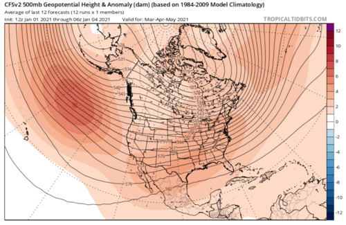
Regardless of any positive signs, man the climate models for AMJ are just resoundingly bad. Not even going to bother posting them, but the consensus from the ECMWF/NMME/CANSIPS/etc. is for another very dead season with a poleward retracted jet (even starting in April this time) along with some serious drought problems given torching temperatures and a lack of precip.
 
Regardless of any positive signs, man the climate models for AMJ are just resoundingly bad. Not even going to bother posting them, but the consensus from the ECMWF/NMME/CANSIPS/etc. is for another very dead season with a poleward retracted jet (even starting in April this time) along with some serious drought problems given torching temperatures and a lack of precip.

Definitely seeing some not great signs on the jet position from the long term models. The one plus is it looks like a good bet for Gulf of Mexico and western Atlantic SSTs to be well above normal again. A stronger Atlantic ridge might not hurt. I still think this year ends up as a crap shoot. Im sticking with my gut which says below normal numbers again this year. The one thing I can say for certain is theres not going to be anything to chase for at least a few weeks with this cold air death surge. Damn Canadians! ;) jk.
 
Definitely seeing some not great signs on the jet position from the long term models. The one plus is it looks like a good bet for Gulf of Mexico and western Atlantic SSTs to be well above normal again. A stronger Atlantic ridge might not hurt. I still think this year ends up as a crap shoot. Im sticking with my gut which says below normal numbers again this year. The one thing I can say for certain is theres not going to be anything to chase for at least a few weeks with this cold air death surge. Damn Canadians! ;) jk.
I know I'm a tornado history guy and all, but it'd be nice to have some... you know... current tornadoes to analyze and/or chase.
 
Just posting for visibility and discussion. Accuweather and company seem to be hedging towards a traditional la Nina spring with the drought taken into consideration. As others have mentioned this is a bit of a 'tweener Nina' in terms of strength and the rapid sring decay. So not sure I buy the 2011 comparison as much, but interesting nonetheless. https://www.accuweather.com/en/weather-forecasts/accuweathers-2021-us-spring-forecast/893237?utm_campaign=accuweather&utm_content=&utm_medium=social&utm_source=twitter
 
Off-topic, but I see AccuWeather's seasonal forecasts as akin to throwing shit against the wall and seeing what sticks.

I don't think there's any reliable way to predict activity level of the spring tornado season beyond aggregate statistics, but we're heading into spring with massive drought in the southwest (although, parts of NW TX, W OK, and W KS have escaped the bad stuff), so that can't be great. Could be looking at strong caps.

Worst part is the synoptic pattern, though. That's what hosed 2018 and 2020. I don't see how that can be predicted at this length.
 
Status
Not open for further replies.
Back
Top