State of the Chase Season 2021

Status
Not open for further replies.
The SPC already put an enhanced risk for day 3 for the upcoming Dixie setup and the ingredients look to be very favorable for a widespread event as far as model guidance shows.
 
This weekend's system has definitely helped improve the drought situation across the southern and central high plains. Better to have a drought in the cool season than in late spring. While chasing in the Texas panhandle this past Friday and Saturday I noticed that the area didn't have the appearance of being in a severe drought. Vegetation was just starting to green up.

There has been a lot of talk about tornado activity being focused east of the plains this year, however that has yet to be the case. Perhaps we continue to see more activity over the preferred regions of the traditional alley moving forward deeper into spring.
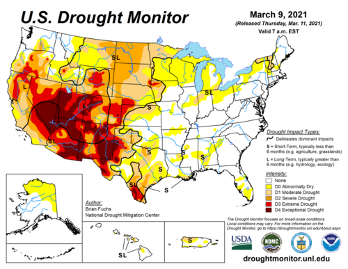
My experience with the spring green-up during a drought is that the drought might delay it and it will definitely clip it off at the top (i.e., the green-up process will stop before all plants have done it), but it won't completely halt green-up. Point being - seeing green-up starting in mid-March may not correlate much to drought magnitude.

What is noteworthy (potentially) is that the large scale drought classification magnitude (DroughtMonitor status) follows a roughly meridional gradient that closely aligns to the climatological spring/summer SGP dryline location. Makes me wonder if this could cause enhancements in the diurnal dryline moisture gradient during the peak of the season and result in big strong drylines.

current_usdm.png
 
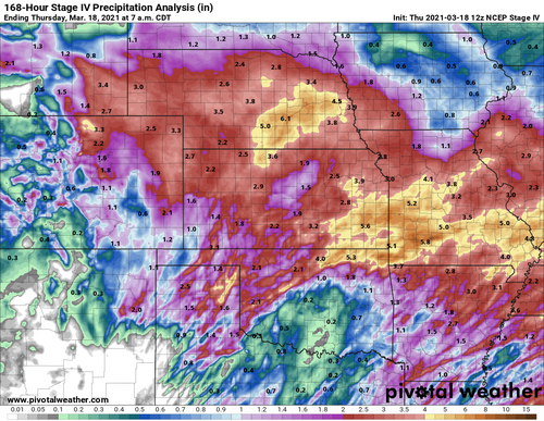
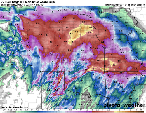
Postmortem on closed low #1: this was an extremely productive drought buster for early March in a Nina year, but focused well N of where it was originally anticipated last week. Essentially all of KS, NE, and E CO experienced potentially game-changing liquid equivalent amounts. Meanwhile, much of TX and OK were left with modest totals, except for the Panhandles and far N/W OK. In the near term, my only gripe with this outcome is that climo favors most of the action closer to the DFW-OKC corridor during green-up over the next 6 weeks. However, these areas are also more likely from a climo perspective to cash in with rainfall in future systems, so this map is outstanding news on the whole. Also, per the DM map Jeff posted above, a large chunk of the area in D1 or worse E of the Rockies last week received at least 1-2" over the weekend.

stageiv_qpe_072h_p.us_c.png

Another potent system will translate across the southern tier of states this week, and it currently looks to bring significant additional precip from the northern Panhandles and SE CO across KS and SE NE. If that verifies, much of KS may be headed into astronomical spring running a surplus on the 1-3 month time scale. Can't ask for much better than that in a Nina year. Provided we eventually get a soaker or two down south, we may be setting the stage for favorable evapotranspiration at least into April and early May across much of the core of chase alley.
 
Quick QPE update after system #2: while not nearly as prolific as the weekend bowling ball, this filled in some relative holes over the Panhandles, N OK, and C KS nicely. Here is the 7-day total ending this morning, 3/18, encompassing both systems.

stageiv_qpe_168h_p.us_c.png

The current consensus forecast through D7 would get the rest of OK and N TX in on the action, meaning virtually none of the southern or central Plains outside the SW corner would go into April with significant short-term drought. Long-term drought remains across much of TX and the High Plains, but I'm feeling pretty good about ET putting its thumb on the scale to keep PBL mixing under control for most setups from the time of local green-up through early May.
 
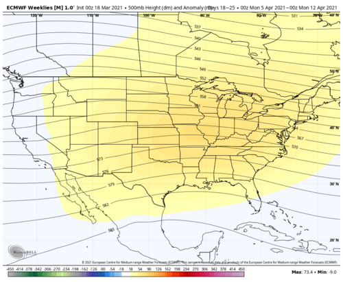
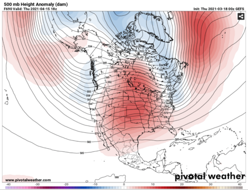
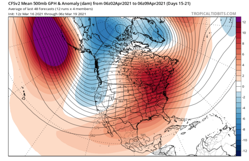
While it appears we will maintain AA conditions for severe (especially in the deep south) through the end of this month; Long range guidance from GEFS, Euro weeklies, and CFS are all showing signs of a poleward retracted jet and a big ridge dominating most of the US. You love to see it. But hey if it's going to happen you'd probably rather see this in April than May (please not both!). CFS weeklies are somewhat of an outlier and attempting to introduce some western troughing favoring high plains and upslope regions the first half of April. Given the time of year I have serious doubts that look would lead to anything noteworthy. First half of April will likely have BA severe.

Perhaps some sort of MJO driven pattern could introduce some action into this period and swing the needle the other way.

Scorecard:

March 1-15 Forecast: BA, Actual: A.... Noteable: March 12-14 Severe Sequence / CO Blizzard
March 16-30 Forecast: AA, Trending: A (criteria already met) to AA....Notable: March 16-18 Severe Sequence / Dixie High Risk.
April 1-15 Forecast: BA

1616177047607.png1616177038265.png
1616177061097.png
 
It seems like the recent trend of precip in KS/NE and also some welcomed liquid precip and heavy snows in Ern CO and Northeast NM coming this week , while not really digging them out of a long term drought hole, is welcomed regardless. Dare I say it may , and I say MAY , play a little role for later this spring? or is that just the optimist in me. lol
 
Last edited:
Doesn't seem as though we'll be closing out March/opening April with much of anything in terms of a chaseable pattern on the Plains. The GFS and Euro have been hinting at us getting ridged out to start April with maybe the chance for a compact cutoff low to swing through the Southern Plains, but this is still sitting well out into fantasy land past hour 240. Like @Michael Gavan noted, better for something like this to hit us in early April and hopefully spare us from some 2006 hell ridge in May.

Non-meteorologically speaking, it's mildly interesting (and somewhat concerning) how our tornado numbers thus far are pretty closely mirroring 2019/2020 seasons. It doesn't mean much of anything in the grand scheme of things, but it will be interesting to see how our late April evolves with a slightly different drought situation and the potential for some additional drought relief over the next 2 weeks.
 
Non-meteorologically speaking, it's mildly interesting (and somewhat concerning) how our tornado numbers thus far are pretty closely mirroring 2019/2020 seasons. It doesn't mean much of anything in the grand scheme of things, but it will be interesting to see how our late April evolves with a slightly different drought situation and the potential for some additional drought relief over the next 2 weeks.

I think that says more about the consistency of the early spring Dixie Alley season than about anything else.

Realistically, most of us are hard-focused on chasing the southern Plains through Midwest and into the southern Canadian provinces. Dixie Alley essentially does not overlap with that at all, so what goes on there is pretty unrepresentative of what's going on in the chase-favorable terrain most of us spend our time on.

Definitely, I don't think there's much of anything to be gleaned about the potential of this season from it, just thought it was interesting in passing.
 
Non-meteorologically speaking, it's mildly interesting (and somewhat concerning) how our tornado numbers thus far are pretty closely mirroring 2019/2020 seasons. It doesn't mean much of anything in the grand scheme of things, but it will be interesting to see how our late April evolves with a slightly different drought situation and the potential for some additional drought relief over the next 2 weeks.

Aside from whether or not the analog will correlate to anything, if it does in fact mirror 2019 that’s not so bad. 2019 wasn’t a bad season (well, it was for me, but that was my own fault 😏)
 
Looks like a quiet period after today (Sunday). Midweek maybe far Southeast US; otherwise, switching to cold Southeast then ridge Plains. Situation should not last long though. Still in the progressive part of the season.

Debate on the MJO, NAO and others going into Mid April. I do not really favor the repeat of last year cold blast. Global wind is not a match. Figure Dixie will reload sometime in April. Maybe two?

Plains late April and May can't come soon enough. Drought is easing, though it's not been a problem. The right systems, that just sharpens the DL. Ridgy long-range (weeks 3-6) but those are not reliable. La Nina barely hangs on and some +TNI hints noted. Regardless only need the atmosphere to lag a few weeks to keep favorable for severe. At least not BN activity I hope.

Both the Plains and Dixie (vs just the South) events have verified at/above forecast most of this season so far.
 
As expected the back half of March was indeed Above Average. In fact, 3 weeks in March almost singlehandedly brought the yearly tornado count up to the average for this time of year.

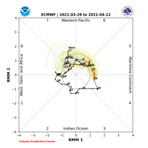
There's some somewhat coherent signal for an MJO orbit, that could possibly result in an 8-1-2, timed for mid to late April.

Earlier signals for a broad ridge across the CONUS have relaxed. Deterministic runs are trying to give us 1 or 2 chances for severe in the center of the country. Not exactly a pattern that looks as active as we just saw, however. I think it might be just good enough to get us a few tornadoes in the first half of April (but still, just below average) I'm leaving first half of April as BA, but I'm not as certain as before. (First half of April's average would be around 50 tornadoes)

CFS Ens and GEFS do not have much agreement on the back half of April. CFS is maintaining CONUS ridging all Month. GEFS has a more westward-shunted upper level pattern that would, at best, provide some moisture starved High and Central plains events on and off throughout the month. But we could get lucky. Chase everything.

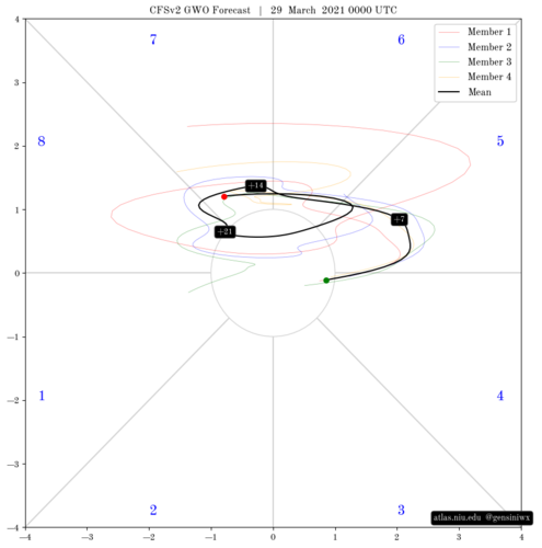
The MJO influence in the second half of April, if it carries through, should get us at least Average conditions. Until there's more certainty in the signal later on, I'm not going more bullish. GWO orbit/AAM drop could also occur around this time.


1617034331929.png1617034830805.png

Scorecard:

March 1-15 Forecast: BA, Actual: A.... Noteable: March 12-14 Severe Sequence / CO Blizzard [Scored 1 tornado]
March 16-30 Forecast: AA, Actual: AA....Notable: March 16-18 Severe Sequence / South High Risk. March 25th South High Risk. March 27th Arklatex/TN Tornadoes [Scored 1 tornado]
April 1-15 Forecast: BA
April 16-30 Forecast: A
 
Status
Not open for further replies.
Back
Top