State of the Chase Season 2021

Status
Not open for further replies.
Yes the flaky Mays of late have driven me to actually chase Dixie Alley. Note that I live in Dixie; so, it's just local outings. When I lived in the Plains I never even gave Dixie Alley a chasing thought (just thoughts and prayers). I'm not sure what I'd do regarding Dixie if I still lived in the Plains.

That said we certainly welcome and appreciate Plains chasers swinging through, spending money, and perhaps we might even meet up - if we see each other through the trees. Plus side, the South still has very little chaser convergence.

Wichita / Plains friends joke I moved to the new promised land. They haven't chased here, ha. Anyway my season strategy is to chase a couple Dixie setups, just in case late-season fails. However in my mind May is still the main event; and, I really look so forward to my Plains trip.

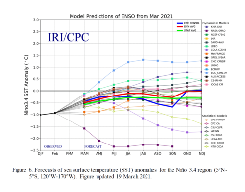
Though this mid-April cool snap echoes 2020, key differences are noted in the ENSO state. SST snap-shot might be similar, but we are coming out of (not going into) La Nina. Usually better by the TNI papers.

Also May 2020 a beautiful jet extension was spoiled by pesky closed lows. Generally those are less favored this phase of ENSO, unless we get an absolutely dreadful GLAAM hiccup. Odds simply favor a normal May, which is game-on for chasing.
 
@Jeff House. I wish I could see what you see in the long term, because CFS weeklies for May look awful. Then again, I think someone mentioned that past two weeks is really hard to forecast.
 
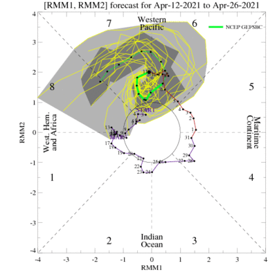
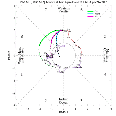
Jeff House(I typed your name , I saw no pop down menu 🤷‍♂️) - We've been seeing some upticks in confidence on tropical system formation over the southern IO and another area over Madagascar over the next few weeks, not sure if this means the MJO is shifting towards phase 7 100% yet, but something to watch for sure. As for the Chase piece, I am committed for end of May now(tickets bought, truck rented), so I'll just do what I have to and I'll be smiling the whole time. I am just not a fan of Dixie chases and never have been.

That said, I am in agreement with the idea that there is just still a lot of time to see how the hemispheric scale is going to effect the Synoptic. Revisit 10-14 days from now and lets see where things are.
 
Though this mid-April cool snap echoes 2020, key differences are noted in the ENSO state. SST snap-shot might be similar, but we are coming out of (not going into) La Nina. Usually better by the TNI papers.

Just anecdotally, it seems like April 2020 was more active (with the Easter outbreak, Bassfield, MS etc taking place a year ago to the day) followed by more activity later in the month which involved the Southern Plains (Madill, OK) in addition to another violent day in Dixie. Then everything by and large shut down for May and even June. It almost seems like everything that happened in April in Dixie last year, happened in March this year.

April hasn't really been a consistent producer of quality chase days for a long time (if indeed it ever was), so I'm not too concerned...yet. Would be nice if the weeklies looked better going into May, but with the skill level beyond 3 weeks being what it is, I'd be more worried if they were showing a perfect pattern for chasing right now.
 
@Jeff Duda. I have very little understanding of the MJO. I know that it can affect the storm season and that certain phases are more favorable. I am curious about when the affects of the phases predicted in the images you showed will take hold if they do?

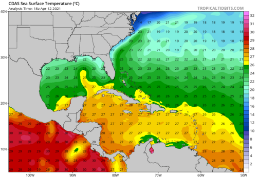
@Jeff House. What do you think about sea surface temperatures in the Gulf of Mexico. How much of a clamper on the season do you think they might be? How detrimental do you think the upcoming cold snap will be to sea surface temperatures in the western Gulf of Mexico?1618285002619.png
 
@Jeff Duda. I have very little understanding of the MJO. I know that it can affect the storm season and that certain phases are more favorable. I am curious about when the affects of the phases predicted in the images you showed will take hold if they do?

I don't have a full understanding of the relationship between MJO and US severe weather either. However, I understand from the literature that, at this time of year, a big swing through phases 8-1-2 will give us a big boost in severe weather activity.
 
I'm not an expert, but I read at Severe Weather Europe, that La Nina and the high temps of the gulf stream (6 to 8 degrees celcius above average) can be a great influence at the coming stormseason.

global-ocean-anomaly-united-states-europe-february-2021-analysis.png-nggid0522251-ngg0dyn-700x700x100-00f0w010c010r110f110r010t010.png


About El Nina, she was stronger than normal and the way she acted, is simular to years wich had a tornado outbreak and very active season. But what do you think about this? Could we see an above-average tornado season in the United States due to the ongoing La Nina this spring?

Below is a graph which shows annual tornado numbers in the United States from 1954 to 2014. Looking at the years, we can see that from the top 5 most active tornado years, 4 were La Nina years. At least for the spring tornado season, which is also the most active part of the year for tornadoes.

spring-weather-season-forecast-united-states-tornado-numbers-by-year.PNG-nggid0521836-ngg0dyn-700x700x100-00f0w010c010r110f110r010t010.PNG
 
I'm not an expert, but I read at Severe Weather Europe, that La Nina and the high temps of the gulf stream (6 to 8 degrees celcius above average) can be a great influence at the coming stormseason.

global-ocean-anomaly-united-states-europe-february-2021-analysis.png-nggid0522251-ngg0dyn-700x700x100-00f0w010c010r110f110r010t010.png


About El Nina, she was stronger than normal and the way she acted, is simular to years wich had a tornado outbreak and very active season. But what do you think about this? Could we see an above-average tornado season in the United States due to the ongoing La Nina this spring?


spring-weather-season-forecast-united-states-tornado-numbers-by-year.PNG-nggid0521836-ngg0dyn-700x700x100-00f0w010c010r110f110r010t010.PNG

From what I understand, the La Nina has pretty much dissipated to near neutral. MJO should be a much bigger influence on seasonal potential.
 
I understand Andy, but is only the presence of La nina in the winter not enough to influence the weather?
What's the meaning of MJO btw?

Subseasonal forecasting at these ranges is complicated. While La Nina tends to produce more severe weather that's not always the case. Several very quiet years have been associated with a resurgent la nina. There are other significant contributions to the overall weather pattern.

MJO stands for the Madden Julien Oscillation which is a cyclic pattern of rising and sinking motion that migrates around the tropics and mid lattitudes What is the MJO, and why do we care? | NOAA Climate.gov
 
April 1-15 has landed "BA" but hasn't been dead quiet. About 30 tornadoes compared to about 50 for climo.

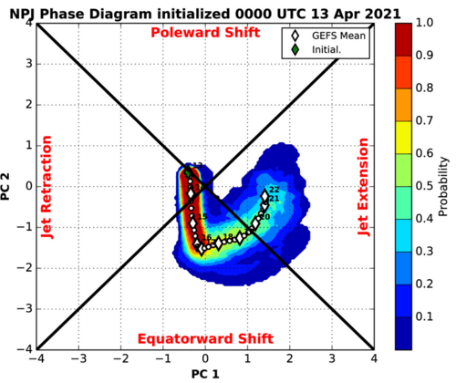
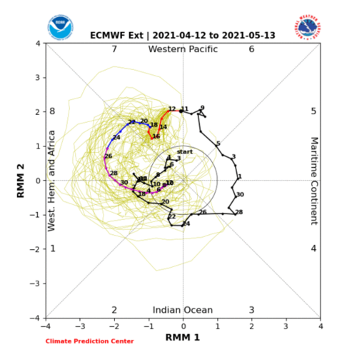
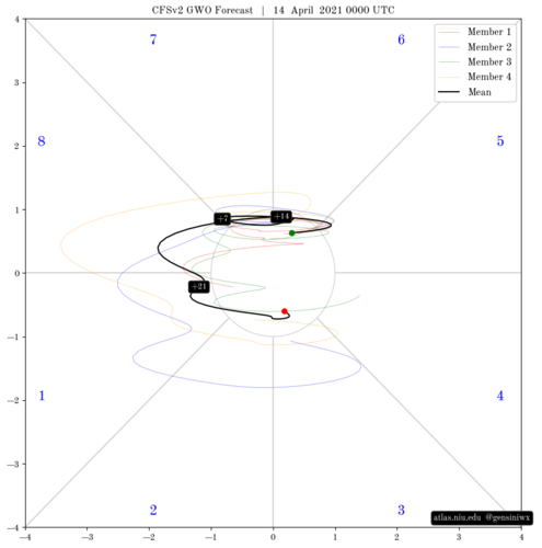
Now for the back half of April, this could get a bit tricky to forecast due to timing and confidence factors. As has been teased in the last 2 weeks, there's some tropical forcing signal, with growing confidence, that could land us some severe weather at the end of the month going into early May. And we're going to need it as long range guidance has so far suggested more ridging, horribly disorganized jet and just a few attempts here and there at some good southwest flow.

Other than the occasional "Del Rio'ing" or South Texas and gulf coast tornadoes, not much is expected until tropical forcing switches things up. So, I'm going to call the back half of April a "BA*" but with a giant asterisk. Or BA+? A-? Can we do that? At any rate, opportunities may exist at the very end of the period, and depending on the ceiling for that activity, might reverse the forecast.

Early May however could be a very different story. Depending on how long this active period persists, it could result in A or even AA conditions. I'm going to go on the aggressive end here because of the time of year, and past examples where this occurred at around the same time period in a similar background state. (1999 for one). In my experience watching these for the past few years, there seems to be delays in getting our AAM drop/GWO-MJO Orbits/Jet extensions compared to forecasts by models. Perhaps that's just me.

Second half of April Climo: ~75 Tornadoes
First half of May Climo: ~100 Tornadoes


1618418116397.png1618418137196.png1618418154674.png


March 1-15 Forecast: BA, Actual: A.... Notable: March 12-14 Severe Sequence / CO Blizzard [Scored 1 tornado]
March 16-31 Forecast: AA, Actual: AA....Notable: March 16-18 Severe Sequence / South High Risk. March 25th South High Risk. March 27th Arklatex/TN Tornadoes [Scored 1 tornado]
April 1-15 Forecast: BA, Actual: BA....Notable: 4-7 to 4-10 active in deep south. My friend's house in Bryon Center, MI got hit by a random EF0, Big Texas hailer
April 16-30 Forecast: BA*
May 1-15 Forecast: AA
 
Status
Not open for further replies.
Back
Top