State of the Chase Season 2021

Status
Not open for further replies.
Beginning to question my BA call for back half of April. I did condition it because of the very end of the period but just 3-4 days of severe can easily swing this to A and beyond. Certainly, the 12z Euro Det. run today taken verbatim would hold amazing potential. But this Ens run? Holy heckfire.


1618957093247.png
 
SPC in with a Day 5 (Friday) risk area over portions of the Southern Plains.

Additionally, GFS has become somewhat consistent with a rather gorgeous 500mb pattern for at least a couple of days in the last week of April. However, it has also been consistent with very strong CIN over much of the would-be target area. It also seems to want to sweep the trough out quickly returning low heights and chilly conditions to the East, rather than holding it back over the West spitting out shortwaves over the central US, which would be the ideal pattern for an extended period of chase opportunities.

Be careful with the FV3 surface and moisture schemes when assessing capping/buoyancy. Theres a well-known dry bias with it that can reduce CAPE and increase CIN significantly. So a capped sounding may not mean nearly as much with the GFS compared to other models until subsequent versions can correct that bias.
 
This is the end of the range for the NAM, about 20 miles WSW of Macon, GA at 2pm EDT. If this holds, south Georgia could have an interesting day on Saturday.
 

Attachments

  • nam_2021042106_084_32.78--83.96.png
    nam_2021042106_084_32.78--83.96.png
    241.9 KB · Views: 0
After the midweek action next week, Euro and GFS both seem to want to cut the trough off and have it sit and spin over the eastern US for a few days. Not sure if prospects are still expected to look up after that, but it appears that it will at least take some time for the pattern to reload.
 
With the current dousing of rain across OK and TX (not to mention the precip in parts of CO yesterday), I'm pretty confident in saying I have minimal concerns as far as moisture goes for the Plains for May. Drought enhanced EML from out west could be a factor (although with good moisture in the Plains, it actually may prove to be a help in certain scenarios), but I'm not seeing a 2014/2018-esque scenario here with widespread issues as far as BL over-mixing goes.
 
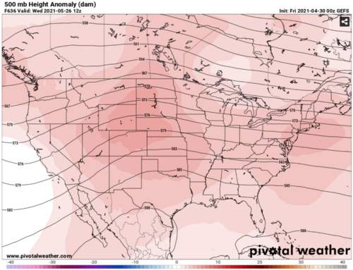
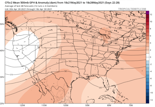
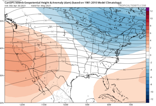
ECMWF weekly forecast just out shows southwest flow over the Plains the week of May 10. Trough parks in the Rockies with SER. Waves eject over the Plains all week. If that verifies, the state of the chase season is about to become very strong.

CFS charts agree. I don't bother with chiclets. GEFS and GFS weeklies (yes GFS now has weeklies) are a little flaky. However CFS and ECMWF agree that May 10 week. MJO/GLAAM would support the scenario.
 
The second half of April 2021 was, as expected, quiet at first followed up by some troughing and activity in the southern plains toward the end of the period thanks to the early onset of tropical forcing. Before that however a sneaky trough managed to pull off some amazing photogenic tornadoes in North Texas on the 23rd and I was very happy to have been a part of that. In total, there were 33 tornado reports in this period, Which while well shy of Average, didn't mean quiet or un-chase-worthy in the least. So I wipe the sweat of my forehead and call that a lucky forecast win.

It also just goes to show 2 things. The arbitrary nature of choosing a 15 day period based on a 450 year old calendar system is, well, arbitrary. And second, chasing in said arbitrary "BA" period can yield some near-career level chases. In my case, my first fully condensed Texas tornado ever, x4, and my most tornadoes in April with 8. Though much of that being owed to a change in circumstances versus my earlier chasing "career"

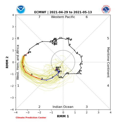
Tropical forcing will continue to help us out through the first half of May with a continued 8-1-2 MJO passage, AAM drop, with considerable uncertainty on the back half of May. Models have been trending better on the second half recently. But forecasted events/Ens. patterns on 5/3-5/4 as well as the 5/8-? period, with opportunities for mesoscale events likely sprinkled in on either side of these periods of interest. I think there is JUST *enough* confidence to stick with that AA through this time frame, though It will take at least one big event out of the bunch to get us to that point in terms of tornado reports. ~133+ Tornadoes in the first half of May is going to be tough as heck to get to. One or two big days in this period will make or break this forecast/gut feeling.

Second half of May has just too much uncertainty and too little help from long range models that seem to have only recently started to think it might be severe friendly. There should at the very least be some risidual help from tropical forcing early in the period. After that, it's peak climo for Tornadoes. Without much confidence, I'm going to go with A, if only barely, for the second half of May. Of course, A at the end of May is music to everyone's ears. Average is surprisingly active for this part of the season. Again, just very low confidence in that forecast. I do also think in 2 weeks this will likely be revised to BA if we don't have another MJO circuit or AAM drop, or some other sign to help us know with any kind of advance warning. If we get a big ridge out of this, well then I guess I will see you on Montana then.
1619845567501.png
1619845825697.png1619845600704.png

Examples of models casting considerable uncertainties afteward:
1619845663738.png

1619845740071.png

1619845783399.png

First half of May Climo: ~100 Tornadoes
Second half of May Climo: ~120 Tornadoes


March 1-15 Forecast: BA, Actual: A....Notable: March 12-14 Severe Sequence / CO Blizzard [Scored 1 tornado]
March 16-31 Forecast: AA, Actual: AA....Notable: March 16-18 Severe Sequence / South High Risk. March 25th South High Risk. March 27th Arklatex/TN Tornadoes [Scored 1 tornado]
April 1-15 Forecast: BA, Actual: BA....Notable: 4-7 to 4-10 active in deep south. My friend's house in Bryon Center, MI got hit by a random EF0, Big Texas hailer
April 16-30 Forecast: BA*, Actual: BA....Notable: 2 Events in Vernon, TX area. Colorado Landspouts. BIG Hail day with a few tornadoes. [Scored 8 Tornaodes/Landspouts, My best April ever by far]
May 1-15 Forecast: AA
May 15-31 Forecast: A


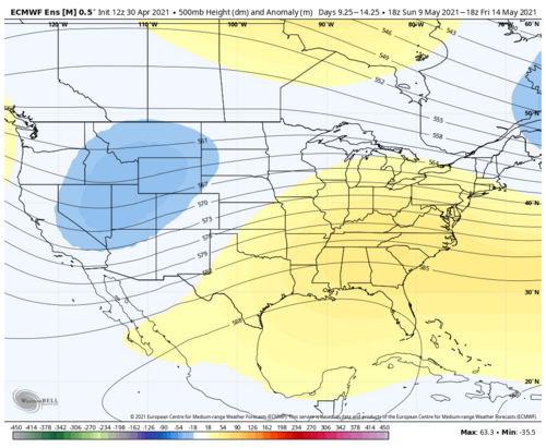
 
In reality..... the "chase" season is sub-par so far. Sure, there was one great day near Vernon, Texas, but that could be labeled as an "anomaly" because the main cell was interacting with another, not a day with multiple productive targets. I'm not a Dixie chaser, so that's off the table. If the week of May 8+ holds up to the current forecast, then we might be set for an extended period of good chase weather.

From the SPC:
"April was a relatively quiet month for severe weather w/ ~ half the normal severe weather reports, the fewest tornado reports since at least '00, and the 4th fewest tornado watches on record. However, a very impactful event occurred Apr 28 when 3 metro areas were hit by 2+" hail."
 
I’ll take what the OZ GFS is showing starting next weekend. Looks like a good pattern setting up for possible multiple days
 
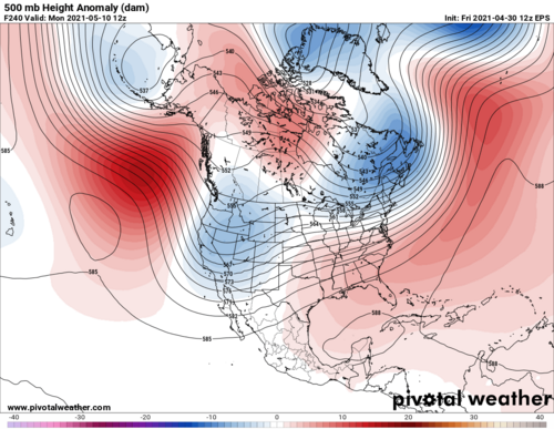
I wish I could join in the exuberance budding in the community the past few days, but from where I sit, the current situation feels like another marker of lowered standards following from year after year of scarcity. The only constant I see in the medium range guidance is perpetual eastern NA troughing, at times appalling in amplitude and wavelength.

As we get deeper into May, we can weather some moderate troughing along the immediate eastern seaboard and still sneak in good events with rich moisture, but the situation looks worse than that for at least the next 7-10 days. Fine; it's still early May. My bigger concern is that we may be squandering an otherwise favorable period in terms of teleconnections and tropical forcing, and that their helping hands may not return again for several weeks, if at all.

Significant shortwaves traverse the southwest U.S. multiple times in the upcoming period, starting today and tomorrow. But they are dwarfed by the Neverending Eastern Canada Spring Vortex Of Doom (TM), resulting in a signature problem of recent years: crashing fronts with most of the best flow on the cold side. Tomorrow is certainly an example of this. Next weekend's opportunity risks being another by Sunday, and before that, moisture return will be problematic at best thanks to the seasonably brutal Gulf wiping earlier in the week.

There may be a window of opportunity for a solid setup early in the week of 5/10, but again, vestiges of eastern troughing are a big fly in the ointment that has to be taken seriously even at these lead times. I'm not here to proclaim there won't be tornadoes or even good chase days between 5/8-5/13; I just think the period looks fairly flawed and not especially impressive, relative to long-term climo for this time of year. It may well be the best opportunity in a relative sense for the first three weeks of May if GEFS/CMCE hemispheric pattern depictions are to be believed, though.
 
That week in question probably won't be big outbreaks. That's just as well. Casualties destroy otherwise good chase days.

Modest to moderate southwest flow is forecast starting about Monday or Tuesday May 10-11. If the front crashes, things could reload by the following weekend. ECMWF does not crash the front anyway. Keeps the buffet line going all that week. Ensembles are a little washed out as usual. However spaghetti plots show the train of subtle waves within southwest flow, and correct low level pressure responses.

More importantly, relative to NWP, the forecast MJO burst and Kelvin Wave is taking shape in the Indian Ocean and Maritime Continent.
 
Having stared intently into the latter portions of the CFSv2 and EMCWF, and though MJO is in its better positioning, I am not seeing the pattern really shape itself into one that sets a synoptic stage that's conducive in late May early June, sparks are here and there, but Its almost like the delivery from East Pac to Canada and Wrn Atlantic are just in an excited/perturbed state with cut off features and split flows in between Omega scenarios. its ugly and its like the AO just doesn't want to give up but being that its running right into the Middle of the Climo High for Tornado season, we may have hit the peak in March and this was another Dixie year. maybe Ern Montana WY later in June/July. I feel like a pessimist!
 
I feel like a pessimist!
You shoulda seen the post I wrote up last night and decided not to post! :oops:

It had something to do with seeing enough evidence to be convinced of some sort of hemispheric or climatic shift that has caused tornado alley to become effectively dormant over the last five years. Each year seemingly brings new lows. Until I see a pattern shift that says otherwise, I'm just going to assume there will be fewer than five chase opportunities in the Central Plains each year and nothing before mid-May.
 
Status
Not open for further replies.
Back
Top