State of the Chase Season 2021

Status
Not open for further replies.
Actually, we saw this in the late 80's. You couldn't believe how few tornadoes there were in Kansas and Oklahoma.

That said, the great Dr. Ted Fujita hypothesized that tornado alley shifts with time. Here is his paper: There Is Nothing New About the Hypothesis Tornado Alley Has Moved East


Jason N said:
I feel like a pessimist!
You shoulda seen the post I wrote up last night and decided not to post! :oops:

It had something to do with seeing enough evidence to be convinced of some sort of hemispheric or climatic shift that has caused tornado alley to become effectively dormant over the last five years. Each year seemingly brings new lows. Until I see a pattern shift that says otherwise, I'm just going to assume there will be fewer than five chase opportunities in the Central Plains each year and nothing before mid-May.

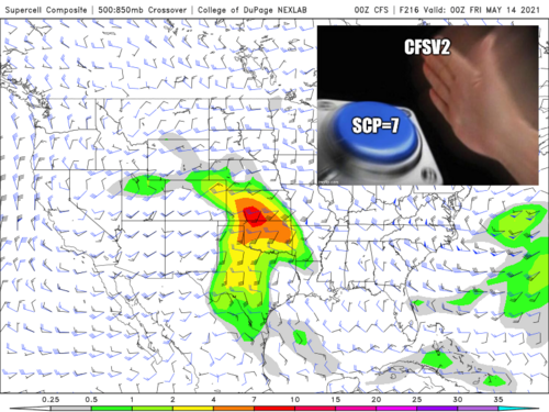
Yep. 2017 and 2019 tried but even seemingly high-ceiling days couldn't deliver with storm-mode issues and bizarre 11th-hour failure modes.

I've been interested in severe weather since childhood, finally started chasing in earnest in 2014, botched two golden opportunities to catch spectacular tornadoes (three, if you add the day AFTER Pilger) over two years, got a brief glimpse of a couple tornadoes...and have had exactly TWO opportunities to get out on what seemed like legit, quality tornado setups after 2016.
 
I consulted the Dr. Fujita paper before moving. Not really!

No denying that all guidance has faltered for the week of May 10. Actually it's quite common for blocking to last a couple days longer than first progged. This is not the 2020 assault of the closed lows. We can patiently wait for GL trough to ease.

Tropical forcing remains out there. EPS and CFS (one ensemble one weekly) both have another West/Rockies trough attempt toward May 15. I know I know, always Day 10+. However the 11-15 day is closer to super peak climo.
 
I'm currently watching the GFS concerning May 19-20 on some consistent 500mb SE flow near the NE/CO/KS border. Reminds me a little of 2019 with a less aggressive tilt on the trough. I'll be taking off on the evening of the 13th to catch a few events I believe may occur between then and the 20th.
 
Not too excited about things after this weekend. Models can no longer be trusted beyond 7-10 days because of EGWPC or "Excessive Global Weather Pattern Constipation." Lots of zonal flow in the extended NCEP forecasts. That little window of opportunity is slowly closing as May 15th. rolls around, as there are generally about 3 weeks remaining of enhanced possibilities. With the modern drought patterns, the EML firewall is a major concern as we close in on late Spring. I'm still maintaining hope for the second half of May, or early June in Colorado. If not, it's Arizona duststorms in July and hurricanes in 3-4 months.
 
I think Mother Nature is just running a little behind. Seems that most of the recent events have been in Dixie Alley and North TX with little to show for in the TX Panhandle and neighboring areas. I have a gut feeling Late May into (especially June) will ramp up around here and in the typical areas of tornado alley (CO and KS).
 
This year is a little different for me in that I don’t have flexibility in when I chase. It’s 5/22-6/6 for me, maybe less (if nothing‘s happening) but not more. So I’m not too worried about what the long range says. Feels rather liberating, to be untethered from that, I will get what I can get, enjoy the time away from reality for better or for worse, and that’s it!
 
I'm locked in chasing during the K-12 school year. Easier for wife when kids are in school. Thankfully school goes late this year. Sorry kids!

Euro ensembles continue bullish. Not just 500 mb anomalies but lee troughs are abundant on surface spaghettis. However the GEFS is meh. Keep in mind average is active in late May. GLAAM continues to rise and is forecast to keep doing so. That's not good through mid-May, less of a problem late May.

Chasers should hope the tropical forcing gains momentum in spite of the GLAAM. -NAO won round one. Perhaps the MJO can win May 15+
 
I am going to attempt to provide a much needed dose of optimism to this otherwise downtrodden thread. While extended robust tornado seasons on the plains are apparently a thing of the past, at least this year we are seeing quality supercells/tornadoes with almost every significant system that comes through. Sure these end up being mesoscale events, and yes the majority of the activity so far has been in the southeast, but Texas has been active as well over the past few weeks.

It may not be the most condusive pattern for chasecationers, but right now we are averaging one or more decent chase opportunities per week. As we enter the climo peak, individual opportunities should become maximized. Hoping the never ending ne CONUS troughing fades by month's end and tropical forcing remains favorable. The high plains of Colorado have experienced a very wet April so perhaps the central high plains will become active before long.

Regardless this year has already exceeded 2020 (which isn't saying much), and we still have the rest of May and June ahead of us. Keep your heads up. At this point all we can do is accept this "new normal" of reduced plains tornado activity and make the most of what we do get.
 
There's no sugarcoating the next 7 days (minimum). Like Brett, I've come to hate any long-term look that features a prominent New England cyclone. The immediate impacts of a wave like that evolving in the near-term is a frontal intrusion into the gulf. It doesn't take a pure wiping into the Caribbean to kill any upcoming setups; just intruding into the northern gulf can be enough if the wavelength is short enough (like for Saturday) to kill a robust setup.

What ends up happening is you get this half-baked modification of the Cp airmass in place, and end up with sky high LCLs *if* you even get CI.

To make things worse, this vortex sure loves to hang around and phase with /shear out any waves attempting to amplify west of the rockies.

While initial model forecasts suggested below normal heights across the intermountain west, there were early signs of this situation playing out. Over the last decade or so, this seems to be the norm.. So it's simply impossible for me to get excited about these patterns anymore.

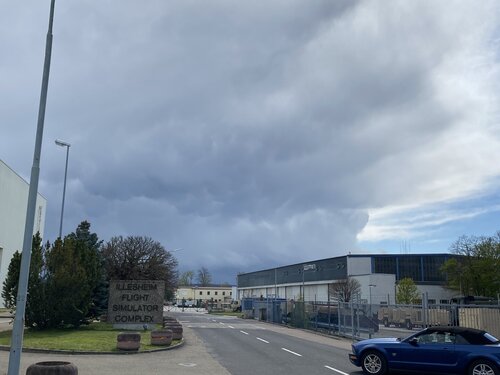
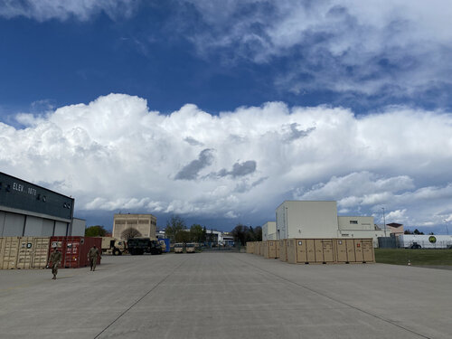
Later in May it's less of a problem, so chasers have that to look forward to. Me on the other hand, I'll just have to settle for very low-topped convection in Germany as I finish up the last three months of a deployment with the Air Force (in support of the Army).A2331FAE-8B69-4856-814A-66337EA16FFF.jpeg
FFD7AE16-DA6F-47E5-8734-ED0B762ECC6C.jpeg
 
My chasecation is scheduled from May 15-23 this year, still holding out some optimism for chase ops during that period (it's still 10+ days out). Even then I have plans to go out for another couple short trips in June/July this year. I haven't done a lot of chasing this year, but I've managed to see some form of tornado on 3 out of 4 chases I've been on with the other chase netting a photogenic supercell and other picturesque scenes. June/July are my best months for chasing up here in the Midwest, so I'm not at all worried.

Meanwhile for the upcoming system, I've been watching the ECMWF which throws out an interesting warm front setup on Sunday in Southern IL. Still days out, so I'm hoping this changes for the better (shifting northward into better terrain and not as saggy with the cold front). I remember back in 2014 though, we had a similar pattern of New England blocking and we had snow showers as late as Mid-May (5/16) here in Illinois with highs in the 30s and 40s. Everyone knows what happened come June that year (Pilger, Coleridge, Alpena etc) and even to a lesser extent a top tier chase event in early July (7/6/14) in Iowa (Traer, IA sunset stovepipe). So every season has its diamonds and this one is still early and I think the diamonds haven't quite developed yet all the way ;)
 
Brett Nickeson,

hahaha yeah I'm sure that a lot of us are trying hard to balance it all. We want to see good setups , we don't want damage to anyone's life or home/livelihood. and with that in mind I think some version of Hamlet is appropriate -- enter stage left (I have the skull of a tornado in my hand staring intently discovering my own philosophy) : "To Swirl, or NOT to swirl, whether it is more noble in thy quest for CAPE and SHEAR fortunes! .. or to take arms against the MJO and opine of the decay of spring - to wither , to die.... to sleep and to dream.
 
There's no sugarcoating the next 7 days (minimum). Like Brett, I've come to hate any long-term look that features a prominent New England cyclone. The immediate impacts of a wave like that evolving in the near-term is a frontal intrusion into the gulf. It doesn't take a pure wiping into the Caribbean to kill any upcoming setups; just intruding into the northern gulf can be enough if the wavelength is short enough (like for Saturday) to kill a robust setup.

What ends up happening is you get this half-baked modification of the Cp airmass in place, and end up with sky high LCLs *if* you even get CI.

To make things worse, this vortex sure loves to hang around and phase with /shear out any waves attempting to amplify west of the rockies.

While initial model forecasts suggested below normal heights across the intermountain west, there were early signs of this situation playing out. Over the last decade or so, this seems to be the norm.. So it's simply impossible for me to get excited about these patterns anymore.

Later in May it's less of a problem, so chasers have that to look forward to. Me on the other hand, I'll just have to settle for very low-topped convection in Germany as I finish up the last three months of a deployment with the Air Force (in support of the Army).View attachment 21579
View attachment 21580
Boy there's a site I am familiar with lol, well at least from Graf and Sembach lol... but the clouds are the same!
 
It is May 6, and there have been 120 Tornado Reports (LSRs). obviously very few of these were in classic chase territory nor were they all particularly predictable. This puts us just 13 short of "Above Average" with 9 days left in my arbitrary forecast period.

An area of interest exists on Saturday May 8 in classic chase country (capping issues due to moisture starvation abound though), followed by several days of opportunities in the south and south Texas. Not ideal territory but some chasability exists.

There are subtle hints that the period around May 15 could yield some results. However long range models are still being just terrible lately with only a good 5-6 days worth of confidence even in ensembles!

Good Luck everyone. And I hope I'll see you out there soon!
 
Status
Not open for further replies.
Back
Top