-
While Stormtrack has discontinued its hosting of SpotterNetwork support on the forums, keep in mind that support for SpotterNetwork issues is available by emailing [email protected].
You are using an out of date browser. It may not display this or other websites correctly.
You should upgrade or use an alternative browser.
You should upgrade or use an alternative browser.
State of the Chase Season 2021
- Thread starter Greg McLaughlin
- Start date
- Status
- Not open for further replies.
Mikaela Norris
EF2
I have my leave approved for the 17th thru to memorial day weekend. I'm in Altus, so minimal travel for me, but I'll definitely be spending this weekend doing final checks on the car/ cameras so I can roll at a moment's notice. Having grown up in Alabama, this will only be my 2nd time chasing the plains (chased north Texas on 20 May 2019, but missed the action to the north). I'm really looking forward to it and hoping to finally get my first tornado. Be safe everyone!
Andy Wehrle
EF5
Andy Wehrle
EF5
@James Hilger , I'm glad everything is apparently so funny to you.
True, at least its been consistent lolGDPS?
Dean Baron
Supporter
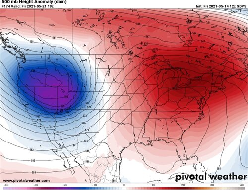
Starting to look like things may finally get more active around Memorial Day weekend. A long ways out but the GFS has been consistent the last few runs in at least showing something. Hopefully that trend continues.
- Joined
- Apr 13, 2009
- Messages
- 81
I'm heading out approx. 5/20-6/1 and I see opportunities. Even if they are not the best it sure beats sitting around the hotel or touring. (A little touring is fine but I'm there to chase!) Also looking forward to chasing after staying home last year.
Brett Roberts
EF5
I will say that the period from Sat-Tue offers prospects that, while I'd still categorize them as the "hope and pray" variety, are at least the more desirable high-CAPE breed? It's a shame we can't get 5-10 kt more mid level flow, or this stretch would be reminiscent of the subtler days in late May 2016 (5/21-5/22). I can live with 35 kt of 0-6 km bulk shear given good CAPE and LCLs, but as of now, we're looking at more like 20-30 kt for this weekend's setups in an area-averaged sense. That puts you in the frustrating regime where a multicell mess is probable, yet the ceiling if you get a boundary or storm interaction at the right place and time is far higher than that. There may be an opportunity for a somewhat more focused setup on Monday from W into N TX and W OK, but it will depend on favorable outcomes regarding shortwave timing and early day convection.
Since these upcoming days are pretty much the definition of "finesse setups" in my book, it will be very interesting to see how PBL mixing impacts moisture by late afternoon each day, since that's often the first prerequisite for overperforming expectations. This style of setup was very productive in years like 2015-16, but led many of us to exasperation and vows to swear off the southern High Plains in years like 2012-13 when you invariably asked yourself by 5pm, "why do I do this to myself, again?"
Since these upcoming days are pretty much the definition of "finesse setups" in my book, it will be very interesting to see how PBL mixing impacts moisture by late afternoon each day, since that's often the first prerequisite for overperforming expectations. This style of setup was very productive in years like 2015-16, but led many of us to exasperation and vows to swear off the southern High Plains in years like 2012-13 when you invariably asked yourself by 5pm, "why do I do this to myself, again?"
JamesCaruso
Staff member
Ugh I wish that would slow down by a couple more days! Going to be a tough decision, do I try to rush out there a couple days earlier than scheduled? If I hadn’t just started a new job it would be a no-brainer. Then again, aside from how it would “look” to start vacation early on short notice, I’m not sure I can get done everything I need to if I don’t have the full week at work... Well as far as the models, it’s early yet, we’ll see what happens, but it’s my understanding that the Euro is not often “too fast” like the GFS, although these biases change and I‘m not a professional meteorologist so I don’t have time to keep up with those model changes, for example is the newest version of the GFS still often too fast???
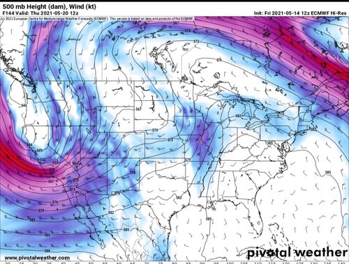
If the 12z Euro has any say, you'll be good pretty much from the 20th to memorial day. The trend is starting to look pretty obvious if you run the loop of the last several Euro's. 20th being the start of an amazing sequence is looking very promising.Ugh I wish that would slow down by a couple more days! Going to be a tough decision, do I try to rush out there a couple days earlier than scheduled? If I hadn’t just started a new job it would be a no-brainer. Then again, aside from how it would “look” to start vacation early on short notice, I’m not sure I can get done everything I need to if I don’t have the full week at work... Well as far as the models, it’s early yet, we’ll see what happens, but it’s my understanding that the Euro is not often “too fast” like the GFS, although these biases change and I‘m not a professional meteorologist so I don’t have time to keep up with those model changes, for example is the newest version of the GFS still often too fast???
Warren Faidley
Supporter
I'd wait to change major plans until more models and ensembles start to agree or trend in the right direction, (if at all). Last year, similar, promising jet configurations either stalled and lost energy or routed north in reality. The 18z GFS 500mb jet looks reasonable through next Wed. (102 hrs), but then it kind of goes Looney Tunes into a gigantic cut off low. I do like how the extended models are hinting of a sloshing dryline for multiple periods. Bring it on.
Haven't they already been trending that way? The past several runs have vastly improved. You couldn't ask for a better mean from the EPS.. Even the gfs is starting to cave to the Euro's look, although it gets sloppy after FH200, I'm not too concerned with that timeframe.I'd wait to change major plans until more models and ensembles start to agree or trend in the right direction, (if at all). Last year, similar, promising jet configurations either stalled and lost energy or routed north in reality. The 18z GFS 500mb jet looks reasonable through next Wed. (102 hrs), but then it kind of goes Looney Tunes into a gigantic cut off low. I do like how the extended models are hinting of a sloshing dryline for multiple periods. Bring it on.
Chris Giddings
Enthusiast
Im going out, like a couple of y’all, Sun - Tues. I’ve got a small window this year thanks to a Memorial Day wedding, a work event on 5/23, and an annual float trip the first Saturday of June. It’s either this 3 day event or an 8 day vacay in mid June thats going to have me spending multiple days just driving to target areas from my home in Houston. Brett Roberts is right in that these 3 days are gonna be “hope and pray” events, but the cape is there, and the latest model runs have been slightly more bullish regarding flow. I’m planning on golfing with my dad in Huntsville tomorrow morning then heading to Abilene afterwards. I’ll decide on either the southern or northern Sunday target from there.
Greg Flint
EF1
I’m in a similar situation, with a trip booked Weds-Sat...but seriously considering moving it up and flying into Dallas Monday in order to target Monday’s Storms. Would be in position for Tuesday as well. I’m just not sure if Mon/Tues/Weds (and maybe Thurs) will be worth it really. Thoughts?
I’m probably making this harder than it needs to be, but if I do commit to go early, I am only looking at Tuesday for sure. I’m concerned I might miss Monday if I’m leaving Dallas around 2pm.
I could be convinced either way but I’d be curious to hear how other’s chase plans might deviate if faced with similar options as me. Do I keep waiting or do I book flight to arrive Monday (tomorrow) right now.
- Status
- Not open for further replies.
Similar threads
- Replies
- 57
- Views
- 6K
- Replies
- 59
- Views
- 9K
- Replies
- 7
- Views
- 1K
- Replies
- 250
- Views
- 44K
- Replies
- 18
- Views
- 5K


