2024-05-06 EVENT: TX/OK/KS/NE

Central Kansas storms are undercut and linear with outflow way ahead of updrafts. New convection trying to go northwest of ICT is mushy and struggling. Also feels cold outside. I'm heading east, undecided about dropping south ahead of the northern storm in OK or just calling the day and heading home for a chance at making tomorrow's setup.
 
Per Mid Level Water Vapor... it looks like significant height falls have now reached the OK/TX border.

I'd expect new storms to explode on the DL.
 
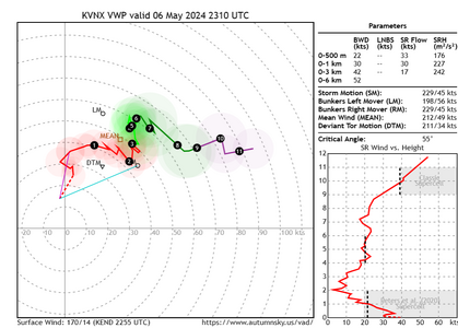
is it me or does the Vance hodo set at BRM look not so favorable in the lowest 1km and below? I wonder if that's just interference with the cell to the SW maybe.. hmm
1715037918064.png
 
I think Jeff was onto to something about a possible gigantic bust. , but its still somewhat early, but I see those supercells now seemingly forming a line.. destructive interference. I did see some of the CAMS form a few discrete cells later tonight NE of OKC. so I am sure this story isn't over just yet.
 
I think Jeff was onto to something about a possible gigantic bust. , but its still somewhat early, but I see those supercells now seemingly forming a line.. destructive interference. I did see some of the CAMS form a few discrete cells later tonight NE of OKC. so I am sure this story isn't over just yet.

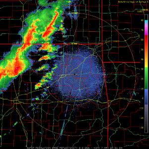
I'm not convinced that it will bust yet, BUT that the daytime potential for highly photogenic, visible tornadoes is narrowing or rapidly closing. However, in the next 2-3 hours I'd expect the actual tornado potential to amplify and remain solid into the middle of the night. It could still be a very dangerous night for central and eastern OK and possibly far SE KS into W MO. Further north the QLCS tornado threat remains real into NE KS and MO and extending into S IA and points eastward. There are far fewer tornado reports than initially thought with the earliest discrete storms in NC OK and SC KS but I wouldn't say it's close to a bust..yet. Still some CINH on the 00z OUN sounding but as the upper-level jet noses into the region and the LLJ amplifies you have a plethora of CAPE, very favorable LCLs, ample streamwise vorticity, and what should be more than adequate low-level shear. While a "bust" would be a best-case scenario for the residents it still holds the potential to be a volatile evening.

image (8).png
 
VTP is the highest I've ever seen it since I've been following weather closely.... upwards of 20 in Oklahoma. The cell up by Hennessey has been trying to get it's act together for a while, if it could tighten up, that thing would be scary based on the radar presentation.
 
I'm with you on the QLCS front. the overnight could still bring something especially with the 850 winds picking up rapidly.
 
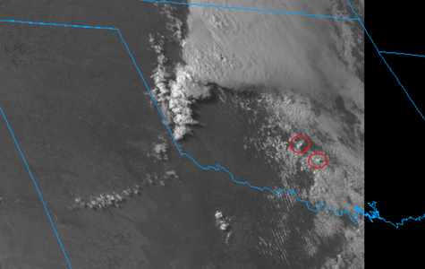
We have 2 new supercells that are maturing in the open warm sector. Could have 3 soon. Will be interesting to watch and see if they get rooted into the BL.

download.png
 
Back
Top