• A friendly and periodic reminder of the rules we use for fostering high SNR and quality conversation and interaction at Stormtrack: Forum rules

    P.S. - Nothing specific happened to prompt this message! No one is in trouble, there are no flame wars in effect, nor any inappropriate conversation ongoing. This is being posted sitewide as a casual refresher.

2024-04-25 EVENT: TX/KS/OK/NE/CO

Joined
Jan 14, 2011
Messages
3,097
Location
St. Louis
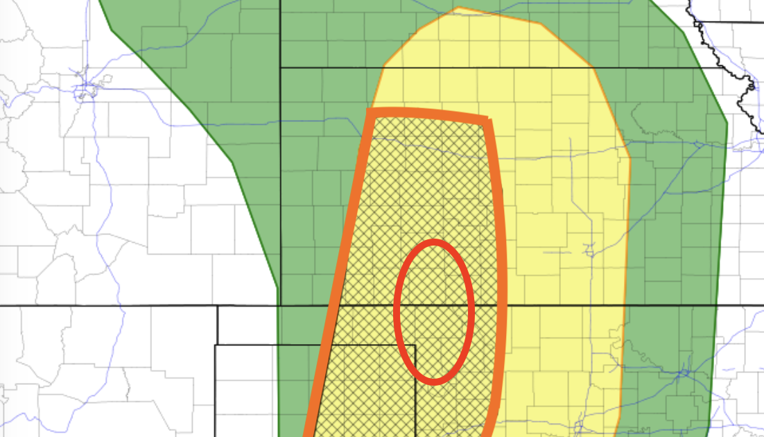
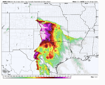
A favorable juxtaposition of the left exit region of a southwesterly jet streak over modest instability on Thursday afternoon/evening in association with an ejecting shortwave trough over the southern/central Plains has been indicated by the Euro, GFS and GEFS ensembles over the past few days. This is shown to be the first in a daily series of several such shear/instability overlaps in the Plains and Midwest, any and all of which appear to have significant severe storm potential.

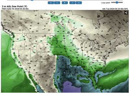
Moisture quality will again be a potential major failure mode for a more robust tornado threat, with the deeper moisture shown well east of the dryline. While details have yet to be resolved, the past few runs of the aforementioned models have favored the Kansas dryline for the most reliable place for convection where shear is favorable for tornadoes, but again, a just-in-time moisture situation is shown. As we've seen many times, whether this concern will be enough to bring the setup's chase quality into question likely won't be resolved until the day before.
 
This is one of the reasons why I don't get too excited about model results 2-3 days from a potential event--they can show interesting things that I attribute to the model output being too far removed in time from it's initial conditions.

This is a plot of the 12Z NAM specific humidity output for 4/26/2024 at 00Z--a full 84 hours out:

1713813029550.png
We get a very sharp dryline with a warm front along a trajectory W central KS through NE OK. (Based mostly on surface variables (pressure, temperature, and specific humidity) and thermal front parameter fields, but also consistent with the gradient in virtual potential temperature and moisture flux convergence analyses.)

Look at the mesohigh analyzed in the TX panhandle. Is this real? Is it the result of prior convection? and if so, when? The NAM STP (not given) shows values of 4-5 near the intersection of the boundary with the dry line, which suggests this area as a potential target for 4/25.

I find it very interesting, and worth the time to check out because it seems so odd, but I bet by Thursday it will be gone.
 
Last edited:
I'm not sure I can recall ever seeing such a déjà vu setup quite so soon after the original. There are so many parallels to 4/15 that I'm finding it difficult to assess any aspect of 4/25 without immediately drawing that comparison.

So, at the risk of oversimplifying, my baseline expectation is a similar result to 4/15: an excruciating, gut-punch type of daytime cap bust along a dryline that just can't quite sharpen up early enough for CI, thanks to yet another very promising synoptic wave mistimed by 6 hours. The distribution of model QPF solutions at this range is unbelievably similar to 4/15: the major global ensembles generally suggest a low but nonzero probability for meaningful QPF in the warm sector before 00z. So far, the "seasonal trend" has been for the cap to win in that scenario... admittedly using a limited sample size.

The copium perspective would be that low-level moisture, while not spectacular, has somewhat less of a just-in-time element to it this time. There's fairly strong NWP consensus for low 60s dews already in place up to S KS by 18z, whereas on 4/15 we were desperately awaiting a major moisture surge during the 22-01z timeframe. Of course, if the synoptic wave does arrive late, the best moisture likely won't get pulled right up to the dryline... and we could end up again with a diffuse gradient from 50 F right on the dryline to 65 F three counties east.

If I had to describe my expectations probabilistically as of this afternoon, I'd put 65% on a Groundhog Day style repeat of 4/15 vs. a 35% on robust CI by 00-01z. Given CI, the expected environment over the E Panhandles into W/C KS looks reasonably favorable for tornadic supercells, even if it's not quite a slam dunk.
 
Capping on the NAM is a bit concerning. It's a little better on the GFS. However, with the drought ongoing at the target and immediately west I would bet the over on capping.

Trying not to put a lot of thought into this yet, but smells like a bust already. I'm liking Wednesday better at this point and I don't really like Wednesday at all.
 
Another set-up I would chase if I was there, but I'm holding out until May 8+ to maximize my 30 day time frame and funds.

Of the 3-4 potential chase days this coming week, I'd be watching those days with some type of outflow boundary interactions from earlier convection.
 
From this far out, the NAM and GFS shows some agreement on 2 general areas of interest... one being near Amarillo and north, and the other near Enid. At this point, I think setting up close to Alva, Ok and adjusting as neccessary is the better bet to see something before dark. Moisture and mass convergence along the warm front in this area during the afternoon coincides with 200+ 0-1km SRH and 2000+ CAPE, and the capping isn't as stout as near the dryline. I'm waiting to see how CAMs handle the morning convection when they come into range, but I think this is worth while setup for those within a few hours drive.
 
I never believed the depth and quality of the moisture would return in time for Thursday’s show. Now it’s only two days out and I’m a believer. Unfortunately I made other plans for Thursday because I was confident of a bust so I’ll have to enjoy the egg on my face if it comes to fruition. The Skew-T grab is from the OKC area.
 

Attachments

  • IMG_0131.jpeg
    IMG_0131.jpeg
    250.9 KB · Views: 23
  • IMG_0132.jpeg
    IMG_0132.jpeg
    264.2 KB · Views: 32
Regarding the potential of a cap bust like 4/15, this time at least some of the CAMS have convection at around 00Z, while in the previous setup, it was pretty unanimous that storms would be hard to come by. That, plus the fact that Saturday looks like a possible outbreak day, we will be heading out in that direction early tomorrow.
 
Yes I agree Thursday will come together with some daylight. Moisture is kind of JIT and existing outflow may be hard to find. However the ATMO will get primed through the day.

I don't see any squirrelly signatures in the upper levels either. Last week some flies in the ointment were already noted 60-84 hours out. Not so this week.

At this time still 57 hours to go, I like just east of the surface low just south of the WF. If a good cell is right on the WF without crossing it shouldn't be too sloppy. I always like 1-2 into the warm sector, but not too far down the DL.

If the morning rain in eastern Kansas can kick an OFB back into western Kansas, I'd target that OFB intersection with DL.
 
Here is my 2¢ for Thursday and Friday.

Both the surface stations in south Texas and the CRP sounding this morning appear to indicate moisture will not be a problem with this one.
The Canadian, UKMET and ECMWF show Thursday will be a "day before the day" situation in the High Plains. The red circle is where I would focus if I had to choose a target this far out.

If things come together, Friday could be a very big day. The question is whether the strong winds at 250 mb get pinched off or continue into the evening.

Saturday (no forecast made yet) is an interesting day. Some random thoughts: There could be a warm front play in KS-OK. Both UKMET and Canadian have a strong surface low between DDC and CDS with a warm front (both models) across NW OK and S Central KS at 1p Saturday. Both models have rich Td's spreading northwest. The 12Z ECMWF at 7pm has rapidly falling pressures in W KS with the warm front across the southern half of the state.
 
Last edited:
Just FYI the NAM/NAM 3 km almost certainly are going to be wrong with temperatures/thermos in the Panhandle Thursday.

They are both showing an anomalous cold pool lingering into the afternoon due to their poor handling of cloud cover and BL mixing. None of the other guidance suggests this. Will there be cloud cover? Sure. Will it be in the 60s at peak heating? Very likely not.
 
With regard to the Day 3 outlook update, it is the first time I've ever seen SPC explicitly forecast EF-4/5 tornadoes in a Day 3.

In both of these areas, storms are expected to move
east-northeastward off the dryline, encountering strengthening
low-level southerly flow and environment that is increasingly
favorable for tornadoes. Low-level shear will continue to
strengthening into the early evening, and the overall environment
supports the potential for strong to intense tornadoes if a discrete
mode can be maintained.


With that in mind, take a look at the SIGTOR from the 18Z 3km WRF valid at 8pm Friday. I'm not sure I've ever seen higher values. Greensburg was only 4.6. Of course, some of the extreme values from models never verify. However, if supercells can get going in this general environment, it could be a big evening.

At this point, conditions for chasing look good -- but remember, chasing after dark can be extremely dangerous.
 

Attachments

  • Screenshot 2024-04-23 at 5.21.17 PM.png
    Screenshot 2024-04-23 at 5.21.17 PM.png
    1,023.1 KB · Views: 32
21Z RAP is out and goes into Thursday evening. Showing a heck of an environment just before dark out by Childress. Capping seems less evident. If we get something kinda isolated, it may go nuts. Extremely good venting above with the 300mb jet hitting right about 00Z. Think we may be seeing some of that "caprock magic" (although I am bastardizing the original definition of that word) we hear so much about.

The 18Z NAM shows some pretty incredible overnight parameters in Northern Oklahoma and Southern Kansas. I'm hoping we're looking at a MCS and not discrete supercells as I fear. Might have some nightwedges if any of that comes close to verifying.
 
Here is a quick and dirty version of Carlson's Lid Strength and Buoyancy terms using a Cap Strength based on Bothwell (1986). The Buoyancy plotted here is based on Carlson's observation that his Buoyancy values were about 1/2 of the standard LI values. You can see cap strengths on the order of 2-3˚C are coincident with the max buoyancy axis. From this it looks like the cap should be breakable on 4/25.

This situation is a world away from 4/15, where the axis of peak buoyancy was displaced E of the dryline by some 50-75 miles and the capping strengh just E of the dryline was on the order of 6-8˚C. (Despite knowing this I still couldn't help myself and ventured into SW KS to watch a beautiful sunset on 4/15.)

RAP_LI-BUOY+CAP_20240423._1500_F051.jpg
Note: This is custom code still in development and even the cap strength is really not the Bothwell Cap Strength as presented in Eblen et. al. (1990), because that method can fail to find the right cap values in the Spring and Fall seasons (near the equinoxes), so I had to modify it. It's pretty close to the LSI Lid, though, and runs lots faster on my poor Mac.

Eblen, Larry H., Judson W. Ladd, and Thomas M. Hicks. "Severe thunderstorm forecasting: an operational review." (1990).
 
Last edited:
I think it's becoming clear my defeatism yesterday around forcing arriving in time for any convection was likely overblown. Modeling has generally sped up a hair, which is the opposite trend we saw last week as that event approached. Between that and moisture that should be a peg or two better, a lot of ingredients appear to be falling into place for a solid event.

The one nagging concern I see while perusing guidance this evening is the potential impact of cool outflow from morning to early afternoon storms in KS. The ECMWF, for example, has gradually trended toward keeping an effective warm front further SW, confining the warm sector to a narrow wedge N of the KS/OK border. Its generally NW-SE orientation means that warm sector storms would likely quickly cross this boundary, rather than riding along it; furthermore, rain-cooled air may be in the low 60s F on the immediate north side.

If the more aggressive morning outflow solutions verify, it may (a) mean a short window of opportunity at and near the triple point in KS, and (b) push the primary focus for long-lived supercells S into the Panhandles and W OK. Unfortunately, it still doesn't seem completely obvious that we will see daytime CI across this southern region. Some models do initiate, but others do not; if you look closely, some of the guidance with big QPF streaks that have led to excitement today are actually on the cool side of the boundary in C KS. Still, I think there's a decent chance of intense surface-based convection somewhere down the dryline. This looks like a chase-worthy day, even if it's quite annoying to realize that a slightly faster shortwave would clear out the warm sector more briskly during the afternoon and make this more of a no-brainer.
 
The two main "solid" targets have been well-covered. I'd also been watching the secondary target in northeastern Colorado. While earlier daytime storms look likely there (the main upside to this area), their window to produce is *tiny* owing to the razor-thin warm sector per the NAM and RAP that the storms will be crossing at a near-perfect 90 degree angle.

I'm still more amiable to the northern primary target thanks to superior terrain/roads, a better chance of a storm there and the fact that the dryline bulge and overhead 500mb chart by themselves are pretty classic-looking.
 
The Euro does not seem as aggressive drawing moisture northward, as the deeper moisture remains south of the warm front. Just lacks the classic look of moisture wrapping into the low. As a result, the better moisture is not co-located with backed winds. Convergence doesn’t look great further south along the dryline into the panhandles. Not seeing much precipitation broken out by the models by 7pm either. I assume the GFS doesn’t have a clue with its brining the warm front all the way up to the KS/NEB border. If I were able to chase, I would probably target somewhere around DDC, where the cap and cloud cover seems less of a concern. SW KS should be in the left front exit region of the upper jet with good diffluent flow aloft.
 
Miscellaneous thoughts....

As of this moment, I don't seen anything to change w/r/t to the forecast I posted above. I'm worried about Thursday and Friday and very worried about Saturday.

I thought it might be helpful (for anyone interested) to pass along some synoptic climatology info from my (too many) years of experience:
  • For strong tornadoes ( ≥EF-2), rain in the morning is a plus. I know that is counterintuitive. At WeatherData, I did a major training paper and looked at all of the violent tornadoes since 1947 and in something like 90% of them, it had rained in the morning. The 1991 Wichita-Andover Tornado (F-5), it poured in the morning in ICT and there was a tornado warning for PNC around 8a. In the case of the Woodward Tornado (F-5, extreme long track), it poured until mid-afternoon. The high for the day was around 7p.
  • The morning rain seems to help lower the LCL.
  • Thursday, the morning rain may set up a "baked boundary" where an outflow line/warm front over the western half of Kansas has a chance to develop some high levels of SRH.
 
Evidence is increasing that indeed a separate outflow boundary will maintain itself south of the WF. The OFB intersection with the DL should produce, and it might produce in a cyclical or long-track fashion. No concerns through the upper levels.

Morning rain in eastern Kansas should kick out an outflow boundary. Rain will depart, so the rainout scenario is not an issue west of I-35 US-81. Just enough cool early to keep that separate form the WF; then, it can bake in the afternoon.

I'm afraid this could be 'the sequence' that seems to happen in April instead of May recent years. Thursday kicks off days through Sunday. My point is that I'd like to be out there. My back-up is already on vacation, not related to weather. Regrettably I won't be.

Boundary intersection is my target. Too early to pick the city or even part of a state. I just know the OFB/DL should be money.
 
Back
Top