2024-05-06 EVENT: TX/OK/KS/NE

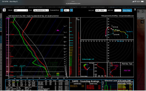
Appears the high res models nailed the storm mode and evolution. Can only assume we'd have seen more daylight tornadoes had storms fired later on and matured in an optimal environment for tornadoes. (before upgrowth into a linear mass)

As it was... lots of messy linear modes in the areas with the best params.

(assuming that's the main reason they didn't produce)
 
I'm assuming the main issue here **so far** is that the cap was too strong further south so storms were not able to form and take advantage of the best dynamics as they moved NE. The storms further north, behaved as expected, forming early in lines with anvil debris and outflows stabilizing the atmosphere as they moved east?
 
I'm assuming the main issue here **so far** is that the cap was too strong further south so storms were not able to form and take advantage of the best dynamics as they moved NE. The storms further north, behaved as expected, forming early in lines with anvil debris and outflows stabilizing the atmosphere as they moved east?
Agreed the CAP was too strong... Or perhaps the cloud cover lasted too long to get sufficient heating to break the cap.

I think i saw the convective temp on the 18z sounding was 87. We got to 81 in OKC/Norman today. So not even close to enough surface heating for explosive development.

In addition, the dryline never made much of a push so we didn't really have any surface convergence to aid in forcing parcels through the cap.
 
I think I mentioned something to that effect (referencing above post) a bit earlier tonight, it might have been that and perhaps the sub 1km wind fields to the timing of the LLJ ramp up, perhaps the storms were offset by the location of the CI. By the time they moved into better low levels further east, the modes were already messy with lots of interference.

The CAMS look to be verifying that stuff IVO Tulsa, but as we saw earlier today, a lot of great radar indicated stuff that just didnt represent on chaser footage. but tonight in that Tulsa north into KS, conditions, if not becoming elevated, are certainly at or near their peak.
 
I'm not convinced anything has gone terribly wrong with the forecasts for this event. I think SPC has just overplayed the daytime threat, and possibly the entire day, too (based on how far west the 30% tor area was). A lot of the CAMs did not exhibit a strong signal of widespread rotating storms; there was a lot of variability among them and some were more bullish, with others being more bearish.

Take this 12-h forecast sounding from the 12Z 3 km NAM for OUN:
nam3km_2024050612_fh12_sounding_35.19N_97.48W.png
It's got the sharp capping inversion and everything. Looks pretty comparable to the observed 00Z sounding...maybe even too strong with the cap. But it also only predicted one real string of UH with this event in OK. Sure, it was very high in magnitude. But keep in mind that's also just 2-5 km UH. That says nothing about tornadoes...just mesocyclones. I'm sure we've had some long track rotating storms today, but the poor shear in the same layer (2-5-km) exhibited in multiple 88D VADs suggest the profile just wasn't great for sustained supercells (see below):KICT_VWP.pngKINX_VWP.pngKTLX_VWP.png
Yeah, shear looks great from 0-2 km, which can get you tornadoes provided the environment doesn't get spoiled by cold pools or other interference caused by crappy supercell dynamics. And I think that's what we have.

Also, it remains the case that the synoptic scale forcing for this event was always displaced to the north, in KS and points northward. I am a bit more mystified at the lack of storm coverage up north, though.
 
I am pretty sure there were probably 3 maybe 4 long track rotating meso's all radar warned, maybe 1-2 that produced brief spin ups and potentially 1 with something more intense deeply rain wrapped, perhaps a sign of that shear profile aloft, but I personally never saw much CC on those cells at all, so, this will be interesting to review further post event.
 
best signature all day, with strong debris ball - Just east of Hominy, OK with 150+ mph of gate to gate.
1715048636031.png

the 0-1 SRH at INX....
1715049218039.png
 
Barnsdall storm formed in the open warm sector. I could see the beginning stages of it as a towering cumulus building east of my location in Moore before it became a storm.

There are now a few more convective showers building up in eastern OK. We could see a few more isolated supercells east of Tulsa in the next few hours.
 
I was listening to Bartlesville PD and Fire on Broadcastify. I heard them say power flashes on the west side of town then the feed went offline. Not good at all.
 
Back
Top