2024-04-25 EVENT: TX/KS/OK/NE/CO

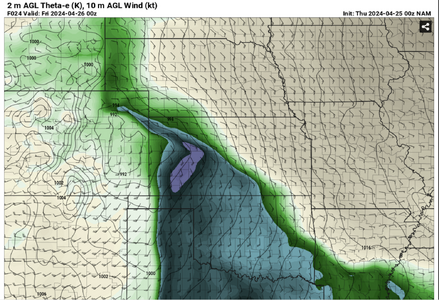
Wouldn't get too attached to southern target. NAM strongly favoring NW KS along WF. HRRR breaks out cells up there and nothing south. As of right now would be my target area.

(Granted, somewhat of a northern bias due to location)

Just my 2 cents after looking at data this evening. (Won't make it out tomorrow but will be out rest of the days)
 
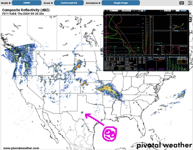
Would not be surprised to see multiple targets along the risk zones from CO into TX. Timing with daylight will be the prize. Tonight is the first time I looked at CAM's, as I don't rely on them too much until the actual chase day. The HRRR does show a nice, isolated cell in my NW TX target zone. Things will be a lot clearer by tomorrow mid-day. I'm assuming AMA and DDC will have an extra balloon launch.
 
Wouldn't get too attached to southern target. NAM strongly favoring NW KS along WF. HRRR breaks out cells up there and nothing south. As of right now would be my target area.

(Granted, somewhat of a northern bias due to location)

Just my 2 cents after looking at data this evening. (Won't make it out tomorrow but will be out rest of the days)
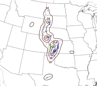
I saw that. The latest NAM has backed off the convergence along the dryline in OK/TX. But not the WF. Capping just off and along the dryline has increased but buoyancies are still good right up against the dryline, which is better than 4/15. Lots of time for things to sour, I guess.
 
Arrived in a timely manner to the KCI region this evening after a graceful trek from AZO, now out through Sunday. For Thursday will focus on W. KS, favoring a region somewhere between US 83 and US 283 [likely south of I-70] for a host of potential parameters and or a conditional bust. Will gravitate along and south of where the boundary establishes and assess as the afternoon progresses.

Great to see Crowther is out, it's like olden times! :D Will keep watch for a tall man near the crossroads community of Dighton standing alongside a rural road while franticly waving his arms about in the air as anticipated parameters attempt to fall into place. Time will tell. Good luck to all roaming the Plains this week!
 

Attachments

  • NAM 0z PT.png
    NAM 0z PT.png
    1.9 MB · Views: 8
Took a look at some early-morning analysis. Cap looks to stay strong in SW KS and TX PH. Not much convergence along dryline. Models seem in agreement with a dryline bulge type of feature in west central / NW KS, with moisture wrapping up around the surface low and backed winds along the warm front. However, this creates a very narrow zone of instability with the NW/SE-oriented warm front and relatively cool air to the east. I think it would be a tough decision to make at this moment (it's only 5am CDT). One possibility is around Hays KS; further north has better backed winds and convergence, but it's a more just-in-time moisture situation (60s dewpoints confined to OK and extreme SW KS right now) and the noted narrower region of instability. SW KS should have deeper moisture and a wider zone of instability, but less convergence along the dryline and a stronger cap. Perhaps there will be an outflow boundary / dryline intersection that provides the necessary convergence. Or maybe open warm sector initiation with large-scale forcing from the mid/upper-level support? I would be thinking a bit east of DDC could be a viable roll-the-dice target. If I were really chasing, I'd want to see more over the next few hours, as it's pretty early yet, and it does not seem clear-cut to me at the moment.

EDIT: When I looked at this 24 hours ago (using OZ 4/24 model runs) the GFS had the warm front and moisture progressing further north in Kansas than did the Euro. The current consensus appears closer to what the GFS was already showing earlier.
 
Last edited:
Looks like 60s dews should be overspreading up to the I-70 corridor by 0Z. RAP meosanalysis showing a minimum of 4 degrees increase in the last 3 hour dewpoint change in SW KS with 50 to 60s already in place N to S.

Ongoing convection may leave outflow in a favorable orientation to storm motion and the dryline closer to I-70 corridor according to vis sat. Currently low clouds/fog over SW KS, but also some clearing evident or likely soon at some stations.

Some convergence on RAP hourly near Scott City this AM. Mesoanalysis TOR Environment browser showing nearly all parameters already within statistical range, and will likely improve toward sig tor during heating.

It seems there will be sufficient forcing in place for cap to break across the region of best parameters by 22Z or earlier. CAMS are firing discrete from NE CO to SW KS by 21-23Z.

My target for today has not changed much since yesterday, initially Scott City vicinity or perhaps a bit more north, adjusting during stops on the drive. I fear the narrowed corridor of best parameters and breakable cap may cause a convergence of chasers as well. :/ For that reason, I may stop and hedge on the NE CO target which still looks to fire earlier than KS.

The much harder question for me is tomorrow and Sat as they will begin to consume vacation days and a lot more gas coming from CO, and less familiar terrain to me that could be closer to more metro areas and river crossings (Friday). Good luck to all who are out this sequence!
 
Last edited:
Appeal to ST chasers: as we move into today's event, I would love it if people would point out OFB or other boundaries they see that can initiate convection. I frankly have a hard time "seeing them, unless they can slap me in the face: lines of cumulus, multiple wind reports clearly delineating local convergence, etc. The more subtle stuff (like a single wind report with no apparent moisture convergence, etc.) just leaves me scratching my head. Numerical analysis covers that deficiency, but only to a point.
 
Appeal to ST chasers: as we move into today's event, I would love it if people would point out OFB or other boundaries they see that can initiate convection. I frankly have a hard time "seeing them, unless they can slap me in the face: lines of cumulus, multiple wind reports clearly delineating local convergence, etc. The more subtle stuff (like a single wind report with no apparent moisture convergence, etc.) just leaves me scratching my head. Numerical analysis covers that deficiency, but only to a point.
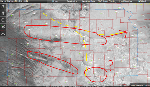
Just looping vis sat I can see a few based on previous convection. I also used yellow dashed lines to delineate areas of mass divergence overlaid on vis sat. The northern boundary was laid down by ongoing convection moving ESE whereas the boundary down near DDC appears to be relatively stationary and has been there awhile, which I actually believe may be the effective surface front (without taking a closer look at surface observations by themselves). That boundary, likely the stationary front, is marking the northern advance of the deeper moisture right now. The convection further south appears to be leaving a subtle boundary but that is likely to be removed from the greater threat area that will materialize in NW KS later.

1714061451585.png
 
Good to see the lack of cirrus (or any cloud cover) upstream of western Kansas. It appears that we'll see at least a 100-mile wide corridor of good insolation east of the dryline. The 96-frame Goodland radar loop shows outflow boundaries slowly moving south of I-70 from overnight convection, but nothing that is surging crazily. The central/eastern KS MCS appears to be on its way out, again without a huge surge of westerly outflow so far. The caveat to that is that the ambient SE surface wind fields across KS favor pulling some of that air toward the dryline.

 
Back
Top