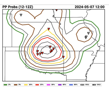
Jason N
EF4
Moist Absolute Instability
here's a link if you feel like reading.
I ALWAYS feel like reading. Thank you!Moist Absolute Instability
here's a link if you feel like reading.
Hey Stan.....haven't seen you since that insane "Simla" et al day in Colorado in June '15. Had to have leg amputated (MRSA infection) plus Cancer at the SAME TIME has kept me out of the alley for chasing. Maybe next year finally....I've got a prothetic leg, I can drive again, etc. Do you remember that outrageous Simla outbreak day? You, my cousin Doren who is my steady chase partner Doren from Salem, Mass and I all stood around taking photos of the ridiculously many separate tornadoes in a side-of-the-road stop for many minutes. Remember it? joel ewingFrom the damage videos in Barnsdall, looks like definite high-end EF-3, probably EF-4. So the high risk was justified, from a chasing perspective your typical hp high risk bust...
Moist Absolutely Unstable Layer - basically, when you have a saturated layer of a sounding in which the lapse rate is greater than moist adiabatic. It is considered to be difficult to achieve in reality and is often a sign of specific behaviors either with instrumentation or in the atmosphere itself. A sounding might falsely depict a MAUL when ascending through a layer of very moist clouds as the sensor deals with possible microscale wet-bulbing via turbulence with the surrounding air. More often than not, though, a sampled MAUL is real. It requires very strong mesoscale ascent in a moist region, typically in the inflow to an established MCS.Please: What is a "MAUL"? (Thanks!)
No. A single violent tornado does not verify an SPC high risk forecast. Forecast probabilities are solely based on coverage of reports, not on intensity. According to the source below, the PP obs yesterday have only verified a 5% for tornadoes so far. More LSRs will likely be added, but it seems extremely unlikely that the max probability contour exceeded will come anywhere close to the necessary threshold for "high", which is 30%.So the high risk was justified, from a chasing perspective your typical hp high risk bust...
Yesterday, I mentioned the synoptic climatology that strong tornadoes are favored in supercells ahead of lines. That is the case right now NW of TUL.
Hey Joel, yeah that was one of my fav chases! Hoping for another one cause im back in CO now, havent really chased (other than armchair) for the past five years cause i've been busy running my gallery--i quit the NWS 7 years ago to do photography full time. Probably the only thing dumber than trying to be a full-time pro chaser ROFL. Hope you recover well and get back out there, probably next year for me too except for short trips to KS/NE/WYHey Stan.....haven't seen you since that insane "Simla" et al day in Colorado in June '15. Had to have leg amputated (MRSA infection) plus Cancer at the SAME TIME has kept me out of the alley for chasing. Maybe next year finally....I've got a prothetic leg, I can drive again, etc. Do you remember that outrageous Simla outbreak day? You, my cousin Doren who is my steady chase partner Doren from Salem, Mass and I all stood around taking photos of the ridiculously many separate tornadoes in a side-of-the-road stop for many minutes. Remember it? joel ewing
No. A single violent tornado does not verify an SPC high risk forecast. Forecast probabilities are solely based on coverage of reports, not on intensity. According to the source below, the PP obs yesterday have only verified a 5% for tornadoes so far. More LSRs will likely be added, but it seems extremely unlikely that the max probability contour exceeded will come anywhere close to the necessary threshold for "high", which is 30%.
View attachment 25332
And while I'm at it, I'll go ahead and toot my own horn of vindication after these PP wind probs suggest a high risk would have verified for wind, just as I suspected in my post early yesterday:
View attachment 25333
although a fine point: the Barnsdall tornado was associated with a discrete cell out in front of the line. If I correctly recall the LSR the first reported tornado was in Hominy.No. A single violent tornado does not verify an SPC high risk forecast. Forecast probabilities are solely based on coverage of reports, not on intensity. According to the source below, the PP obs yesterday have only verified a 5% for tornadoes so far. More LSRs will likely be added, but it seems extremely unlikely that the max probability contour exceeded will come anywhere close to the necessary threshold for "high", which is 30%.
View attachment 25332
And while I'm at it, I'll go ahead and toot my own horn of vindication after these PP wind probs suggest a high risk would have verified for wind, just as I suspected in my post early yesterday:
View attachment 25333
In the mid-70's, Steve Tegtmeier, a classmate of mine at OU, did a masters thesis of synoptical climatology patterns that lead to tornadoes. To my knowledge, he was the first to document the "dry line bulge" and "isolated cell ahead of a line." In addition, he told us that solid (as opposed to broken or scattered) lines were less likely to produce major tornadoes. All of this information was new.Question on the Barnsdall / Bartlesville storm - what is the mechanical lifting mechanism for an open warm sector storm like that? Was it outflow from the line to its west? Or general large scale forcing from the upper trough? Some other source?
And is there ever any real basis for targeting a particular spot for an open warm sector storm (other than a boundary of some sort, in which case it’s no longer really an “open warm sector storm”) or is it pretty much a random / chaos theory thing?
That was one of the topics discussed prior to the evolution of the High-risk day was the crossover wind orientation from 850 to 500. I noticed and mentioned here about the clouds and ConvT as the day was unfolding as well. I think as you said above, the Anvil overspreading over a more SCT/BKN low level that didn't clear out enough in advance to spike temps may have limited some of the dynamics below the LFC maybe since I think everything above that was certainly more than favorable in terms of large scale lift and shear, and as mentioned by several here now, the timing/location of the initiation, and perhaps sub 1km wind vorticity generation issues IVO the CI location, but that's just a guess there.It's interesting to see some of the SPC employees chiming in with their theories as well, particularly that the ejection of the trough and upper level jet core were such that storms didn't really move off the dry line perpendicular to the shear but rather sort of trained and interfered with each other. Sometimes I don't think to look at cloud features on chase days as closely as I should, but Cameron made a good point about the mammatus present in the downstream environment and how storms were moving into areas where stratus clouds existed from earlier. I wonder if that could have been another fly in the ointment with convective temperatures previously being shown in the upper -80s, something like maybe around 87°, whereas some of those shallow clouds may have held temperatures back in Oklahoma and contributed towards maintaining some of the CINH too.
I was watching the observations and radar, and I am not 100% sure, but it appeared as though there may have been a confluence line that initiated the cells, and at the time when they first started to loft, the LLJ was peaking out in a clear zone undisturbed by the line to the west. I didn't see any outflow influence at the time they fired offQuestion on the Barnsdall / Bartlesville storm - what is the mechanical lifting mechanism for an open warm sector storm like that? Was it outflow from the line to its west? Or general large scale forcing from the upper trough? Some other source?
And is there ever any real basis for targeting a particular spot for an open warm sector storm (other than a boundary of some sort, in which case it’s no longer really an “open warm sector storm”) or is it pretty much a random / chaos theory thing?