• After witnessing the continued decrease of involvement in the SpotterNetwork staff in serving SN members with troubleshooting issues recently, I have unilaterally decided to terminate the relationship between SpotterNetwork's support and Stormtrack. I have witnessed multiple users unable to receive support weeks after initiating help threads on the forum. I find this lack of response from SpotterNetwork officials disappointing and a failure to hold up their end of the agreement that was made years ago, before I took over management of this site. In my opinion, having Stormtrack users sit and wait for so long to receive help on SpotterNetwork issues on the Stormtrack forums reflects poorly not only on SpotterNetwork, but on Stormtrack and (by association) me as well. Since the issue has not been satisfactorily addressed, I no longer wish for the Stormtrack forum to be associated with SpotterNetwork.

    I apologize to those who continue to have issues with the service and continue to see their issues left unaddressed. Please understand that the connection between ST and SN was put in place long before I had any say over it. But now that I am the "captain of this ship," it is within my right (nay, duty) to make adjustments as I see necessary. Ending this relationship is such an adjustment.

    For those who continue to need help, I recommend navigating a web browswer to SpotterNetwork's About page, and seeking the individuals listed on that page for all further inquiries about SpotterNetwork.

    From this moment forward, the SpotterNetwork sub-forum has been hidden/deleted and there will be no assurance that any SpotterNetwork issues brought up in any of Stormtrack's other sub-forums will be addressed. Do not rely on Stormtrack for help with SpotterNetwork issues.

    Sincerely, Jeff D.

2025-03-14 EVENT: MO/AR/IL/IA/TN/MS/LA

Joined
Jan 14, 2011
Messages
3,429
Location
St. Louis
We finally have some agreement in various model depictions of Friday's event as the main upper trough ejects and its attendant strong surface low spins up and moves northeast. As was feared initially, the influence of the preceding wave's departure will prevent high-end moisture (above 60F) from making it much farther north than the Interstate 40 latitude. A weird cut-off blob of moisture from the previous wave is shown lingering, but it is drifting too far east to enhance the target convection. In addition to the lack of moisture, another major negative is the mostly boundary-parallel flow aloft. The typically-favored surface low arc of storms (in central Missouri back northwest into the core of the low) will suffer from that, with models depicting a forced squall line moving at race car speeds. The translational speed of the line eastward is shown to be around 50mph: it's at Booneville Missouri at 21z and already in St. Louis at 00z. Individual cells/mesos in the line will be rocketing northeastward at 60 or 70 mph.

I would favor the first discrete cells early in the afternoon the farthest northwest you can get with any meaningful instability, closer to the coldest temps aloft and closer to the vorticity-rich surface low. As it's shown at this point, that looks like southwest Iowa/northwest Missouri and maybe even a touch west of there. My feeling right now is that window will be too short to be worth the drive from here, given the prospect of Saturday action to the south. My plan at this point, barring major change, is just to shoot lightning here with the squall line as it blazes past.
 
the influence of the preceding wave's departure...forced squall line...shoot lightning...
I figured you might. There's some weather pictures to be had with this powerful system. Damage pictures too, as a nerve-wracking night's on the table for people under the threat of night-time, forward-flank tornadoes Friday near & after sunset. And the next day, secondary low pressure around Memphis keeps the threat going in the Southeast. As an aside, my jarring, night-time event was an F2 tornado that went over my Mid-City New Orleans apartment in the pre-dawn hours one February night sounding like the buzzing of 1000 bees. It really sounded like that.
 
There has been some slight improvement in northward moisture transport during the 06-12z model cycles, the NAM being the most optimistic (and the outlier ATTM) with the 60F line making it to I-64 after 00z in central/southeast Illinois. All of the others show a more solid, albeit narrower, swath of mid to upper 50s at that latitude. Wind profiles have improved in the low levels, with some workable turning below 850mb. If the outlier NAM is to be believed, southern Illinois could be a solid player, albeit after dark.

I fear staying ahead of things may be a challenge. Basically I-64 or I-70 are the only real options, with short 1-3 minute stops at exits. Going through a town or even a construction zone slowdown could be chase enders. Once the line gets ahead of you, you're not getting back in front (such is the case for most early season mega-trough events).
 
Last edited:
The ceiling for this event has been trending upward, thanks to later arrival of storms allowing for 1-3 more hours of moisture return. CAMs have been indicating a supercell mode for some time now, particularly across southern Illinois with more models placing the 60F dewpoint line well north of I-70 by 02z . Again though, storm speeds are virtually unchaseable, meaning this will be a single-intercept event for most chasers.

The tornado environment as-shown in the St. Louis metro is on the level only seen maybe 3 or 4 times in the past 20 years. I fear we're not going to get through this one without a major tornado in the metro.
 
Last edited:
00z model runs continue to look favorable for southern and even mid-Illinois, with the HRRR and RAP both showing sustained 60s dews and low-level CAPE after the system moves through the St. Louis metro.

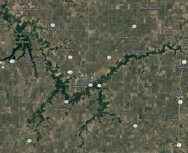
60 kts of NE storm motion is not a maintainable chase, but if intercepting the line/semi-discrete storms were a goal, then Taylorville, IL could be an option to try to maximize maneuvering options and visibility. In addition to a strong network of paved north-south county roads in the area, there is an intercardinal crossing of state routes 29 and 48. Outside of the thin strip of trees that wrap Taylorville, it is very open farmland all around, more so than along I70 to the south. Timing for the area seems to be around 03-04z from the latest runs.
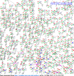
1741926054308.png
 
...environment as-shown in the St. Louis metro is on the level only seen maybe 3 or 4 times in the past 20 years.
We're seeing something truly extraordinary w/ setups over the next couple of days & nights. Once again, pick your location & watch it blow by.
Note to self from SPC for future: "12hr mid-level height falls on the order of 240-270m."
 
Last edited:
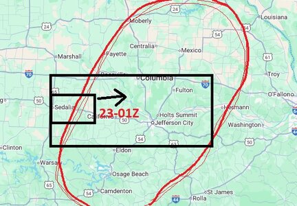
If it were me right now, I'd Stage out of Sedalia MO, staying inside the box, playing along and in between of I-70 and 50 for sure to stay out from the worst trees while tracking east with the storms from 21/22Z to 01Z . appears the best moisture/shear dynamics.. the line obviously progresses after dark but the issues and complexities of chasing after dark have their own set of safety problems that I probably wouldn't want to contend with. The central issue of forward storm propogation speeds. its looking like storm motions of up to 40-45kts make keeping up with storms on some roads tough. pre-positioning let it come to you.. then bounce way ahead, jackrabbit like.. then rinse and repeat the cycle is easy in some areas out west.. more difficult near populated areas.

chase area.jpg
 
I have chased many of these mega-trough outbreaks with 60mph+ storm speeds and have found that staying ahead of the line even with a clear, due-east interstate is difficult. Letting the activity catch you to get a look at one storm's base/meso will more often than not result in the next cell in the line handily beating you to the next road crossing point. This is mostly due to its heavy forward flank precip moving over the road in front of you and slowing down your maximum safe speed. I've had many of these where I only got a look at one storm, then could never get caught up again to catch a second one.

Add to that if there is *any* hail in the precip of the next storm ahead of you, panicky/selfish drivers parking under overpasses can result in the road being blocked entirely.

With slightly slower storm speeds, I would start in Columbia, MO and move east with the line. But I think doing that will result in the line getting ahead of you almost immediately, leaving you in the dust for everything to the east. I believe the best play is to stay far ahead until it starts producing, then allow one of the cells to catch up. I hope that the big-time tornado potential doesn't start kicking in until the line is east of STL, but the way CAMs are painting things, I fear that might start well to the west of the city and persist all the way through the metro area.
 
All good points Dan, and echos my feelings as well. The combination effects in the wrong areas of travel can/will kill a chase before it really even gets started when you have storm speeds over 45-50mph over more complicated road routes.

I picked my area mainly because it sits in the more southern end of the line that appeared to be advancing a little slower (40+kts) to the east, despite the SE-NW storm vector winds of 60kts+. Heck the more northern end of that whole complex seems to get caught up in that uni-directional wind field, jet max and what looks like a fairly significant cold pool outflow. it looked like some part of the complex were forecasted to move at 70-80kts in some places.
 
Definitely feels like a historic 2-day event incoming . If the moisture trend continues, we're into High Risk territory tonight. No need for a home target bias with this one, unfortunately. The other caveat with positioning optimally for Friday will greatly hinder one's prospects of making it south for tomorrow with any sleep.
 
we're into High Risk territory tonight
Completely agree. If I were at SPC, I would have it "high risk" 60 miles either side of a line from 30 mi NNW of UIN to 50 SSE of STL. Farther south, the tornado point probability will be lower but strong tornadoes are likey after 10pm.

I would also be forecasting a high risk Saturday.

I'm really worried about the casualty toll from this 2-day event.
 
Definitely feels like a historic 2-day event incoming . If the moisture trend continues, we're into High Risk territory tonight. No need for a home target bias with this one, unfortunately. The other caveat with positioning optimally for Friday will greatly hinder one's prospects of making it south for tomorrow with any sleep.
I think it could be pulled off. from my earlier post.. if you were "disciplined" to pull off the chase by 01Z. from the area I outlined, starting from Sedalia east to St. Louis to Jonesboro... say about 4hrs drive time south, with even some possible chase stops along the route south as the line on that southern side seems to slow up a tad bit with some discreet or semi-discreet activity that moves across route 55 south. Hotel there from 11pm to 8AM, then 4hrs further south gets you to Jackson, MS by Noon... The key would be, mark your ONE or TWO cells... stick with a small area target or two for a couple hours, and no matter what is happening elsewhere., break off the chase and go, and then maybe catch something further south off of 55 before you bed down for the night.
 
Last edited:
Another note for any chasers targeting the St. Louis area: Interstate 255 on the Illinois side has a long segment closed that has no quick bypass. I don't think that highway is going to be a major player for any chase strategy today (you really need to stay on east-west highways for this) but it's worth noting if you are coming north on I-55 in Missouri and trying to get to I-64 or I-70 eastbound.
 
Back
Top