-
While Stormtrack has discontinued its hosting of SpotterNetwork support on the forums, keep in mind that support for SpotterNetwork issues is available by emailing [email protected].
You are using an out of date browser. It may not display this or other websites correctly.
You should upgrade or use an alternative browser.
You should upgrade or use an alternative browser.
2024-04-25 EVENT: TX/KS/OK/NE/CO
- Thread starter Dan Robinson
- Start date
Ben Holcomb
EF5
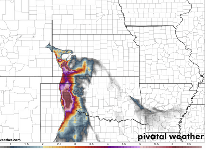
21Z RAP is out and goes into Thursday evening. Showing a heck of an environment just before dark out by Childress. Capping seems less evident. If we get something kinda isolated, it may go nuts. Extremely good venting above with the 300mb jet hitting right about 00Z. Think we may be seeing some of that "caprock magic" (although I am bastardizing the original definition of that word) we hear so much about.
The 18Z NAM shows some pretty incredible overnight parameters in Northern Oklahoma and Southern Kansas. I'm hoping we're looking at a MCS and not discrete supercells as I fear. Might have some nightwedges if any of that comes close to verifying.
The 18Z NAM shows some pretty incredible overnight parameters in Northern Oklahoma and Southern Kansas. I'm hoping we're looking at a MCS and not discrete supercells as I fear. Might have some nightwedges if any of that comes close to verifying.
gdlewen
EF4
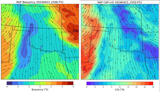
Here is a quick and dirty version of Carlson's Lid Strength and Buoyancy terms using a Cap Strength based on Bothwell (1986). The Buoyancy plotted here is based on Carlson's observation that his Buoyancy values were about 1/2 of the standard LI values. You can see cap strengths on the order of 2-3˚C are coincident with the max buoyancy axis. From this it looks like the cap should be breakable on 4/25.
This situation is a world away from 4/15, where the axis of peak buoyancy was displaced E of the dryline by some 50-75 miles and the capping strengh just E of the dryline was on the order of 6-8˚C. (Despite knowing this I still couldn't help myself and ventured into SW KS to watch a beautiful sunset on 4/15.)

Note: This is custom code still in development and even the cap strength is really not the Bothwell Cap Strength as presented in Eblen et. al. (1990), because that method can fail to find the right cap values in the Spring and Fall seasons (near the equinoxes), so I had to modify it. It's pretty close to the LSI Lid, though, and runs lots faster on my poor Mac.
Eblen, Larry H., Judson W. Ladd, and Thomas M. Hicks. "Severe thunderstorm forecasting: an operational review." (1990).
This situation is a world away from 4/15, where the axis of peak buoyancy was displaced E of the dryline by some 50-75 miles and the capping strengh just E of the dryline was on the order of 6-8˚C. (Despite knowing this I still couldn't help myself and ventured into SW KS to watch a beautiful sunset on 4/15.)

Note: This is custom code still in development and even the cap strength is really not the Bothwell Cap Strength as presented in Eblen et. al. (1990), because that method can fail to find the right cap values in the Spring and Fall seasons (near the equinoxes), so I had to modify it. It's pretty close to the LSI Lid, though, and runs lots faster on my poor Mac.
Eblen, Larry H., Judson W. Ladd, and Thomas M. Hicks. "Severe thunderstorm forecasting: an operational review." (1990).
Last edited:
Brett Roberts
EF5
I think it's becoming clear my defeatism yesterday around forcing arriving in time for any convection was likely overblown. Modeling has generally sped up a hair, which is the opposite trend we saw last week as that event approached. Between that and moisture that should be a peg or two better, a lot of ingredients appear to be falling into place for a solid event.
The one nagging concern I see while perusing guidance this evening is the potential impact of cool outflow from morning to early afternoon storms in KS. The ECMWF, for example, has gradually trended toward keeping an effective warm front further SW, confining the warm sector to a narrow wedge N of the KS/OK border. Its generally NW-SE orientation means that warm sector storms would likely quickly cross this boundary, rather than riding along it; furthermore, rain-cooled air may be in the low 60s F on the immediate north side.
If the more aggressive morning outflow solutions verify, it may (a) mean a short window of opportunity at and near the triple point in KS, and (b) push the primary focus for long-lived supercells S into the Panhandles and W OK. Unfortunately, it still doesn't seem completely obvious that we will see daytime CI across this southern region. Some models do initiate, but others do not; if you look closely, some of the guidance with big QPF streaks that have led to excitement today are actually on the cool side of the boundary in C KS. Still, I think there's a decent chance of intense surface-based convection somewhere down the dryline. This looks like a chase-worthy day, even if it's quite annoying to realize that a slightly faster shortwave would clear out the warm sector more briskly during the afternoon and make this more of a no-brainer.
Dan Robinson
EF5
The two main "solid" targets have been well-covered. I'd also been watching the secondary target in northeastern Colorado. While earlier daytime storms look likely there (the main upside to this area), their window to produce is *tiny* owing to the razor-thin warm sector per the NAM and RAP that the storms will be crossing at a near-perfect 90 degree angle.
I'm still more amiable to the northern primary target thanks to superior terrain/roads, a better chance of a storm there and the fact that the dryline bulge and overhead 500mb chart by themselves are pretty classic-looking.
I'm still more amiable to the northern primary target thanks to superior terrain/roads, a better chance of a storm there and the fact that the dryline bulge and overhead 500mb chart by themselves are pretty classic-looking.
JamesCaruso
Staff member
The Euro does not seem as aggressive drawing moisture northward, as the deeper moisture remains south of the warm front. Just lacks the classic look of moisture wrapping into the low. As a result, the better moisture is not co-located with backed winds. Convergence doesn’t look great further south along the dryline into the panhandles. Not seeing much precipitation broken out by the models by 7pm either. I assume the GFS doesn’t have a clue with its brining the warm front all the way up to the KS/NEB border. If I were able to chase, I would probably target somewhere around DDC, where the cap and cloud cover seems less of a concern. SW KS should be in the left front exit region of the upper jet with good diffluent flow aloft.
Matthew Crowther
EF4
I wonder if SPC's upgrade jinxed it- almost all models except a couple of CAMs have backed off on daylight convection, we will see.
Mike Smith
EF5
Miscellaneous thoughts....
As of this moment, I don't seen anything to change w/r/t to the forecast I posted above. I'm worried about Thursday and Friday and very worried about Saturday.
I thought it might be helpful (for anyone interested) to pass along some synoptic climatology info from my (too many) years of experience:
As of this moment, I don't seen anything to change w/r/t to the forecast I posted above. I'm worried about Thursday and Friday and very worried about Saturday.
I thought it might be helpful (for anyone interested) to pass along some synoptic climatology info from my (too many) years of experience:
- For strong tornadoes ( ≥EF-2), rain in the morning is a plus. I know that is counterintuitive. At WeatherData, I did a major training paper and looked at all of the violent tornadoes since 1947 and in something like 90% of them, it had rained in the morning. The 1991 Wichita-Andover Tornado (F-5), it poured in the morning in ICT and there was a tornado warning for PNC around 8a. In the case of the Woodward Tornado (F-5, extreme long track), it poured until mid-afternoon. The high for the day was around 7p.
- The morning rain seems to help lower the LCL.
- Thursday, the morning rain may set up a "baked boundary" where an outflow line/warm front over the western half of Kansas has a chance to develop some high levels of SRH.
Derek Weston
EF5
DDC AFD. Agrees with potential, but concerns (for their region) are 700 temps and morning convection.
 forecast.weather.gov
National Weather Service
Jeff House
Supporter
Evidence is increasing that indeed a separate outflow boundary will maintain itself south of the WF. The OFB intersection with the DL should produce, and it might produce in a cyclical or long-track fashion. No concerns through the upper levels.
Morning rain in eastern Kansas should kick out an outflow boundary. Rain will depart, so the rainout scenario is not an issue west of I-35 US-81. Just enough cool early to keep that separate form the WF; then, it can bake in the afternoon.
I'm afraid this could be 'the sequence' that seems to happen in April instead of May recent years. Thursday kicks off days through Sunday. My point is that I'd like to be out there. My back-up is already on vacation, not related to weather. Regrettably I won't be.
Boundary intersection is my target. Too early to pick the city or even part of a state. I just know the OFB/DL should be money.
Sean Ramsey
EF5
Haven't looked at the hi-res models yet, but NAM had 8-9° C 700 mb temps in SW KS/NW OK/TX PH and latest RAP run is showing 10-11° with Lid Strength also running stout, albeit with a window of opportunity between 21z-0z. But like on the 15th, with a stationary/somewhat retreating dryline during prime hours may leave us hanging until after dark. Agree on the nighttime monsters possibility.
Jesse Risley
Staff member
Were any of these events exacerbated by remnant OFBs from convection earlier in the day? The factor in lowering LCLs makes perfect sense, although depending on the degree of diurnal heating an atmosphere can certainly mix out if there is too much heating for too long, thus raising LCLs.Miscellaneous thoughts....
As of this moment, I don't seen anything to change w/r/t to the forecast I posted above. I'm worried about Thursday and Friday and very worried about Saturday.
I thought it might be helpful (for anyone interested) to pass along some synoptic climatology info from my (too many) years of experience:
- For strong tornadoes ( ≥EF-2), rain in the morning is a plus. I know that is counterintuitive. At WeatherData, I did a major training paper and looked at all of the violent tornadoes since 1947 and in something like 90% of them, it had rained in the morning. The 1991 Wichita-Andover Tornado (F-5), it poured in the morning in ICT and there was a tornado warning for PNC around 8a. In the case of the Woodward Tornado (F-5, extreme long track), it poured until mid-afternoon. The high for the day was around 7p.
- The morning rain seems to help lower the LCL.
- Thursday, the morning rain may set up a "baked boundary" where an outflow line/warm front over the western half of Kansas has a chance to develop some high levels of SRH.
Mike Smith
EF5
A lot of them were pre-GOES satellite.Were any of these events exacerbated by remnant OFBs from convection earlier in the day? The factor in lowering LCLs makes perfect sense, although depending on the degree of diurnal heating an atmosphere can certainly mix out if there is too much heating for too long, thus raising LCLs.
Clearly, Greensburg was influenced by an outflow line/gravity wave that lay just south of Highway 400.
1991 Wichita-Andover Tornado was likely influenced by one. The cell fired in NW Oklahoma but didn't produce big tornadoes until it appeared to intersect with a boundary over southern Kansas. It was the only storm that produced an F-5.
Dr. Erik Rasmussen did quite a bit of research on this topic and I believe it was he who coined the term "baked boundary." His research clearly showed stronger tornadoes tended to occur near these lines.
Jeff House
Supporter
The May 2004 Harper-Attica four cycles of tornadoes over two hours was on an outflow boundary intersection with DL south of the synoptic WF.
Kingfisher County, OK May 24, 2008 (May 24 is a great date!) was on an outflow boundary south of the WF. 3 great cycles before it got HP.
Rozel 2013 was on outflow. May 24, 2016 Shootout at Dodge City was outflow. I was not at Pilger but again believe it's outflow.
Do we see a theme related to excellent chasing?
Jesse Risley
Staff member
I chased Pilger and indeed morning convection left a remnant OFB between rain-cooled air to the north and a fairly unstable airmass to the south over eastern/NE Nebraska. The Plainfield, IL F5 in August 1990 may also have involved some sort of diffuse boundary to enhance wind shear (LOT mentioned this one time in a synoptic review of the event although I do not know if that was an OFB from morning convection or not).The May 2004 Harper-Attica four cycles of tornadoes over two hours was on an outflow boundary intersection with DL south of the synoptic WF.
Kingfisher County, OK May 24, 2008 (May 24 is a great date!) was on an outflow boundary south of the WF. 3 great cycles before it got HP.
Rozel 2013 was on outflow. May 24, 2016 Shootout at Dodge City was outflow. I was not at Pilger but again believe it's outflow.
Do we see a theme related to excellent chasing?
Similar threads
- Replies
- 31
- Views
- 2K

