2024-04-25 EVENT: TX/KS/OK/NE/CO

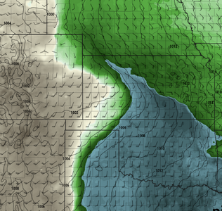
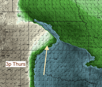
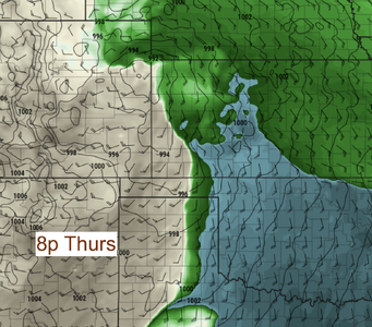
I can't recall seeing westward outflow from storms so far to the east making it all the way into far western KS, pinching off the dryline from south of the bulge as some models are wanting to do now. During the 2018 landspout event, there was an MCS that sent westerly outflow into the dryline, but it was much farther west, at around Quinter.
 
I can't recall seeing westward outflow from storms so far to the east making it all the way into far western KS, pinching off the dryline from south of the bulge as some models are wanting to do now. During the 2018 landspout event, there was an MCS that sent westerly outflow into the dryline, but it was much farther west, at around Quinter.

The FV3 shows the airmass "reloading" with the DL retreating west during the evening which looks reasonable to me. Greensburg was a backing up DL, as was the 1970 F-4 LBB Tornado, and quite few lesser-known tornadoes.
 
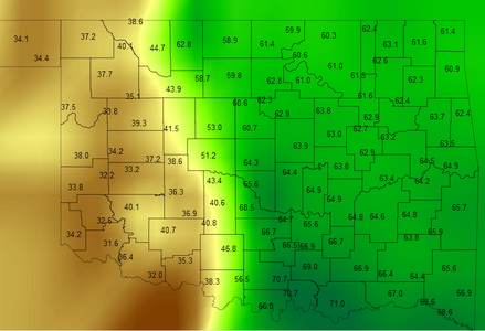
To add to Mike's point above, we definitely had rain the morning of the Wynnewood tigers back in 2016 in Southern Oklahoma. Things cleared out about 9-10 am but there was a marked increase in dewpoints of almost 10ºF in some places like Ardmore. Part of that may have been the pushing dryline as well, but fog and/or rain in the morning seems to be a hallmark of big days so maybe there is something to it.
 

Attachments

  • 20160509-1600z-dewpoint.png
    20160509-1600z-dewpoint.png
    188.4 KB · Views: 41
  • 20160509-2100z-dewpoint.png
    20160509-2100z-dewpoint.png
    201.2 KB · Views: 10
The FV3 shows the airmass "reloading" with the DL retreating west during the evening which looks reasonable to me. Greensburg was a backing up DL, as was the 1970 F-4 LBB Tornado, and quite few lesser-known tornadoes.
So---what does "reloading" mean, in this context? (Thanks!)
 
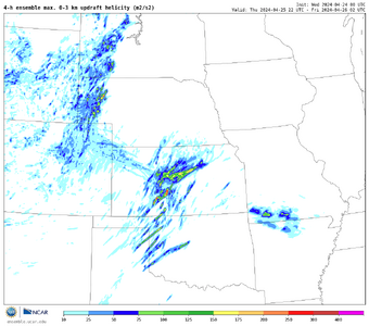
Haven't been paying terribly close attention to this day, except when I checked the overnight CAM runs from NSSL and noticed some UH tracks in NW KS and NE CO, which is a play I could potentially make. Some other experimental ensemble forecasts highlight the potential of robust rotating storms as well.

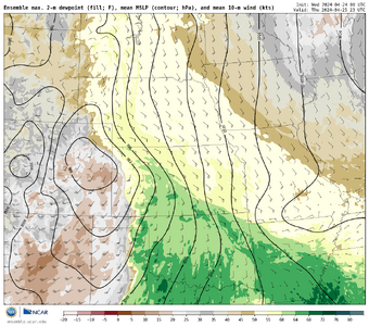
The first ensemble, NCAR's C-SHiELD, doesn't seem too excited about moisture:
ensemble mean
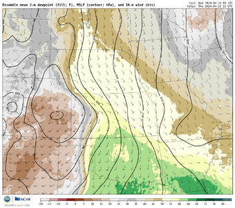
td2_mean_f046_CGP.png
ensemble max
td2_max_f047_CGP.png
This leads me to believe that higher LCLs may be a factor in reducing the quality/intensity of storms that do form:
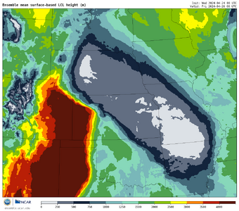
zlcl_mean_f048_CGP.png
However, most members to fire storms, and some of those members maintain a cellular/discrete mode after 00Z. It's far from a majority, though (members 1, 5, 6, and 9 look sexy):
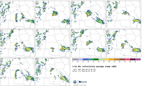
ref1km_stamp_f049_CGP.png
And the ensemble max UH fields reflect this, both with mid-level and low-level rotation:
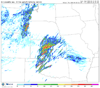
hmuh_max_f047-f050_CGP.png
hmuh03_max_f047-f050_CGP.png
So I definitely see reasons to be optimistic.

The MPAS ensemble, on the other hand, looks to be more friendly with the surface moisture:
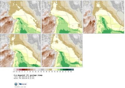
td2_stamp_f045_CGP.png
But it seems to favor a more linear storm mode despite having more shear over the DL from N TX through S KS. But boy if that second member verifies...
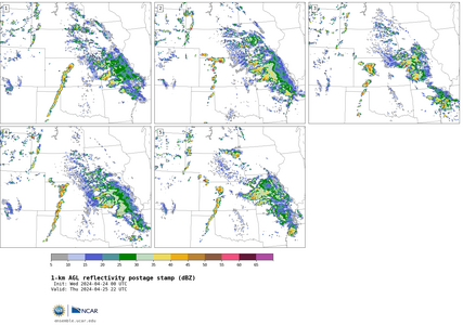
ref1km_stamp_f046_CGP.png
Rotation tracks look a little less prominent, but there are definitely some bigger values, especially in NC KS.
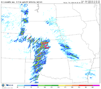
hmuh_max_f045-f048_CGP.png

I even see some hints of rotating storms in NE CO, too! However, likely due to a final surge of moisture around and after 00Z, the largest increase in UH track presence across both NE CO and W NE happens after 00Z, which puts daylight storms in that area in question.
 
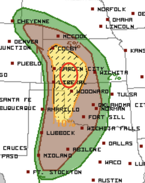
Looking at those of this morning's CAMs that extend to the period of interest, the majority of them do initiate precipitation by 0Z or before that somewhere in SW Kansas or the northeast Panhandles. Based on that, I have decided to pull the trigger on a chase. It is not sure-fire due to the uncertainties discussed above regarding capping and the position of the WF/outflow boundary, but I think that storms during daylight somewhere in that general area are more likely than not. The latest SPC outlook also seems to agree with that thinking. Will pre-position in Lamar, CO for tonight, then refine the target based on data that come in tonight and tomorrow morning.
 
I have moved my area of highest risk (red) for tomorrow a little bit to the north.

My forecast reasoning has not changed.

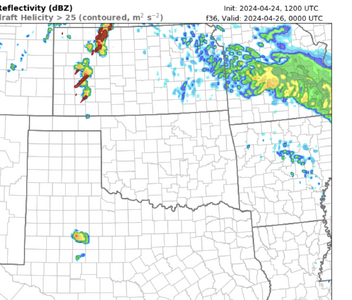
Addition: Here's the Texas Tech WRF which has a good reputation for forecasting severe thunderstorms. This is valid 7pm Friday with the one hour UH tracks.
 

Attachments

  • 25.png
    25.png
    396.3 KB · Views: 29
  • Screenshot 2024-04-24 at 1.24.41 PM.png
    Screenshot 2024-04-24 at 1.24.41 PM.png
    750 KB · Views: 27
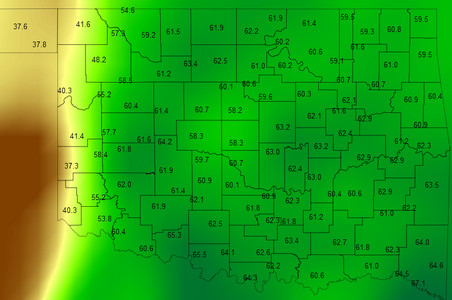
I'm encouraged to see 65+ dewpoints already north of the Red River 24 hours before the event. Finally we have a setup that isn't struggling with "just in time" moisture. The timing of tomorrow's system appears to be on track for a bit earlier arrival compared to the system on the 15th. Still some uncertainties regarding cloud cover, degree of lift along dryline, and capping, but it does appear we have a greater shot at sustained convection this go around. Obviously, if we get a storm(s) to break the cap and have a discrete mode going into the 23-02z time frame, then we should end up with a memorable evening. 18z NAM and GFS still show strong capping, so that is definitely a concern, but I sure wouldn't want to miss this setup if it goes off.
 
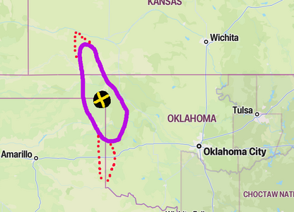
Thursday is one of those classic, data-overload situations if chasers are not careful and keep it simple. I'll be missing this set-up, but would base out of the NE Texas Panhandle by mid-day and adjust accordingly. My targeting priorities as of 4-24 pm is attached. Graphics are based on my own preferences of chase terrain, initial storm mode and "simple" forecasting. There may be just enough N/S targeting options by showtime tomorrow to spread out the hordes and Klingon Empire.

chasr copy.png
 
Moisture looks on track with mid 50s dews making their way across TX/OK currently.

Both GLD and DDC have highlighted likely overnight convection and tomorrow a maybe-breakable cap in parts of their areas, both of which could modify this event either way in the KS or CO areas to be a nothing or decent day.

700mb animated temp loops are still consistently trending on a strong but not nuclear cap almost all areas, which I am not expecting to change much, with a couple pockets of slightly weaker capping on average across several models that paints a couple targets more likely for earlier initiation. Convective temp forecast to be achieved handily in these pockets/bands, but not in widespread area. I'm not fully sure what all the models take into account to predict these cap erosion or weaker cap 'pockets', so taken with a grain of salt when next to large swaths of hot 700mb.

HRRR and NAM 3K are a bit far out for my tastes to make solid plans, but last few runs all have solid helicity swaths in either or both of W KS or NE CO. With current info, I will likely pre position at either roughly: Scott City, KS, or Idalia, CO.

TX panhandle also appears like cap could break but a bit far for me to consider seriously.

Can't determine much more until later model runs and morning surface obs. are available.
 
I plan on chasing tomorrow. The DDC area forecast discussion, presumably going off the NAM and GFS, is still emphasizing the strength of the cap but like others have said, the potential if something can break through and organize is excellent. 00z forecast soundings around Scott City all suggest a broken cap, nice elongated hodographs and varying degrees of TOR risk. Current plan is to aim for that area, check satellite and try to find a cumulus field and/or an outflow boundary baking in the sun all afternoon, and run with it from there.
 
CONUS vis sat shows quite a cirrus plume associated with the approaching upper trough. The good news, is it doesn't appear the cirrus is overly dense, so I would expect filtered insolation tomorrow under that cirrus plume.

It's nice to see everyone on here discussing the next few days. Seems like there hasn't been much of that the past several years. Happy hunting, and see you all under the meso.
 
The 0Z HRRR seems to be depicting a fairly wide warm sector in Kansas, so it's not seeing the outflow pinching off the warm sector there as shown on some of the Euro and NAM runs yesterday as @Brett Roberts pointed out. However the dryline is not depicted as very sharp with the 60s dews again hanging out a few counties to the east at 23Z. It does fire simulated supercells, but only at the northern fringe of the warm sector/along the warm front, and strong northward component of motion suggests these might cross the front quickly.
 
Thursday is one of those classic, data-overload situations if chasers are not careful and keep it simple. I'll be missing this set-up, but would base out of the NE Texas Panhandle by mid-day and adjust accordingly. My targeting priorities as of 4-24 pm is attached. Graphics are based on my own preferences of chase terrain, initial storm mode and "simple" forecasting. There may be just enough N/S targeting options by showtime tomorrow to spread out the hordes and Klingon Empire.

View attachment 24957
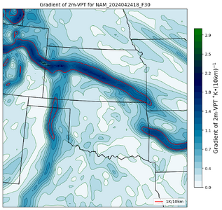
@Warren Faidley...At the risk of introducing more data overload--4/24/2024 18Z NAM for tomorrow evening at 00Z:

The virtual potential temperature (VPT) gradient analysis tends to confirm your target area. Magnitudes of the VTP gradient on the order of 1-2˚K per 10km are sufficient to drive solenoidal circulations--enhancing fine-scale low level moisture convergence, for instance--so I indicate the 1˚K/10km contour in red. Significant gradients are projected just west of your target area. I will be very interested to see if this holds tomorrow....

NAM_20240424_18Z_F30_Gradient of 2m-VPT ˚K•$(10km)^{-1}$.png
 
Back
Top