Brian McKibben
EF3
The VIL on the Carnegie storm is really coming up. Tops just peaked up to 50k ft. So I think this storm is starting to root into the BL and beginning to take off.Looks like the cap is finally letting go in SW OK.
The VIL on the Carnegie storm is really coming up. Tops just peaked up to 50k ft. So I think this storm is starting to root into the BL and beginning to take off.Looks like the cap is finally letting go in SW OK.
Pretty unlikely at this point. The BL is undergoing the overnight transition so there isn't a whole lot of a diurnal CBL left to root into. It's only able to attain marginal mesocyclonic rotation and is probably struggling to pull SB parcels up through the increasingly resistant CIN layer. It will probably become mostly elevated soon enough, although that won't stop it from achieving at least some level of rotation and hail threat. Can't yet write off the tornado threat, but I suspect is is pretty low at this point.The VIL on the Carnegie storm is really coming up. Tops just peaked up to 50k ft. So I think this storm is starting to root into the BL and beginning to take off.

Please: What is a "MAUL"? (Thanks!)Definitely some impressive composite indices, but considering there's probably a thin MAUL above the moist layer giving the impression of there being less CIN than there probably actually is and the S-shaped hodograph in the 2-5-km layer, storms look to continue to struggle to attain or maintain supercell characteristics.
I ALWAYS feel like reading. Thank you!Moist Absolute Instability
here's a link if you feel like reading.
Hey Stan.....haven't seen you since that insane "Simla" et al day in Colorado in June '15. Had to have leg amputated (MRSA infection) plus Cancer at the SAME TIME has kept me out of the alley for chasing. Maybe next year finally....I've got a prothetic leg, I can drive again, etc. Do you remember that outrageous Simla outbreak day? You, my cousin Doren who is my steady chase partner Doren from Salem, Mass and I all stood around taking photos of the ridiculously many separate tornadoes in a side-of-the-road stop for many minutes. Remember it? joel ewingFrom the damage videos in Barnsdall, looks like definite high-end EF-3, probably EF-4. So the high risk was justified, from a chasing perspective your typical hp high risk bust...
Moist Absolutely Unstable Layer - basically, when you have a saturated layer of a sounding in which the lapse rate is greater than moist adiabatic. It is considered to be difficult to achieve in reality and is often a sign of specific behaviors either with instrumentation or in the atmosphere itself. A sounding might falsely depict a MAUL when ascending through a layer of very moist clouds as the sensor deals with possible microscale wet-bulbing via turbulence with the surrounding air. More often than not, though, a sampled MAUL is real. It requires very strong mesoscale ascent in a moist region, typically in the inflow to an established MCS.Please: What is a "MAUL"? (Thanks!)
No. A single violent tornado does not verify an SPC high risk forecast. Forecast probabilities are solely based on coverage of reports, not on intensity. According to the source below, the PP obs yesterday have only verified a 5% for tornadoes so far. More LSRs will likely be added, but it seems extremely unlikely that the max probability contour exceeded will come anywhere close to the necessary threshold for "high", which is 30%.So the high risk was justified, from a chasing perspective your typical hp high risk bust...


Yesterday, I mentioned the synoptic climatology that strong tornadoes are favored in supercells ahead of lines. That is the case right now NW of TUL.
Hey Joel, yeah that was one of my fav chases! Hoping for another one cause im back in CO now, havent really chased (other than armchair) for the past five years cause i've been busy running my gallery--i quit the NWS 7 years ago to do photography full time. Probably the only thing dumber than trying to be a full-time pro chaser ROFL. Hope you recover well and get back out there, probably next year for me too except for short trips to KS/NE/WYHey Stan.....haven't seen you since that insane "Simla" et al day in Colorado in June '15. Had to have leg amputated (MRSA infection) plus Cancer at the SAME TIME has kept me out of the alley for chasing. Maybe next year finally....I've got a prothetic leg, I can drive again, etc. Do you remember that outrageous Simla outbreak day? You, my cousin Doren who is my steady chase partner Doren from Salem, Mass and I all stood around taking photos of the ridiculously many separate tornadoes in a side-of-the-road stop for many minutes. Remember it? joel ewing
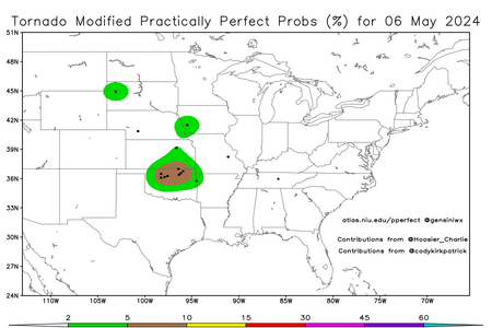
No. A single violent tornado does not verify an SPC high risk forecast. Forecast probabilities are solely based on coverage of reports, not on intensity. According to the source below, the PP obs yesterday have only verified a 5% for tornadoes so far. More LSRs will likely be added, but it seems extremely unlikely that the max probability contour exceeded will come anywhere close to the necessary threshold for "high", which is 30%.
View attachment 25332
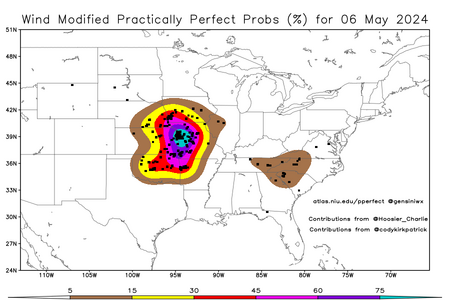
And while I'm at it, I'll go ahead and toot my own horn of vindication after these PP wind probs suggest a high risk would have verified for wind, just as I suspected in my post early yesterday:
View attachment 25333
