From all of the models I've looked at, this event looks to me to be more likely to verify as a high risk for wind than for tornadoes. Things look more strongly forced in KS with discrete supercells looking less likely than a hybrid mode of a linear band with embedded supercells. In OK, the synoptic scale forcing looks to only brush by rather than impact the area fully, so getting widespread storm development seems less likely, although the mode would be cellular.
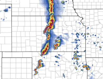
Various CAMs are scant on UH tracks across OK, although the most intense UH tracks are in OK. The AI-backed MMFS doesn't seem to buy into the tornado threat in general, though:
View attachment 25288
View attachment 25287
This product was up into the reds on last Friday's tornado outbreak in NE/IA.
Meanwhile, its depiction for wind is as follows:
View attachment 25289
The 1-km NSSL WRF does show a long-track storm over W/C OK this evening, with very high 0-1 km UH values suggestive of a long-track supercell producing tornadoes for a long time:
View attachment 25290
That would be a major event if it verifies, but that alone would not verify a high risk. May 31st 2013 was a moderate risk day and for good reason - the storm coverage was very low despite the huge intensity of those that developed. I remember conversing with SPC forecasters that day and they refused to go High risk due to the low coverage.
 ).
).