2024-05-06 EVENT: TX/OK/KS/NE

I'm on the fence about chasing tomorrow. I've been through quite a few chaser convergence events starting with Kingfisher in 2010 and most recently in Hinton a little over a week ago. I've always been aware of it, but have a really hard time avoiding it since I chase alone and don't leave the pavement if I can help it. I didn't see barely a soul on that Hinton storm as it moved its way up from Roosevelt. Minutes after it went tornado warned every chaser in the nation showed up and I was in gridlocked traffic from HWY 152 north and lost the storm pretty much at that point (as everyone else did). I did pretty well with patience but I've thought about it more and more since then.

If you can't really stay up with the storm you're chasing and it's not enjoyable because you're frustrated with traffic, avoiding accidents, can't pull off because there's so many others filling any turnout, afraid to turn out because it may be a while before you can get back on the road, not to mention worrying about getting slammed by the storm itself and having no way out, then what's the point? When I was younger I didn't care as much, but now I do.

I figure all the media chasers, youtube chasers, chase tours, chase-cationers, the regulars (chasers) and the locals will all be out in force tomorrow as is standard for May these days. Is it worth all the possible grief? Dunno, but I don't need to see a tornado that bad.

That being said, if I do get out I may head out to western or northern Oklahoma or southern Kansas as "alternative" targets, plus it would allow me to be close to home and family if anything approaches OKC. Plus, SW Oklahoma might produce one of those I-44 specials where turnpike chasing isn't much fun either and I'd like to avoid that as well.
 
The target area has definitely moved south compared to late last week. Recent CAMs are depicting a cold front in north and central KS, which will provide more widespread forcing and like several have said above, shear and storm motion are now more parallel to the front/dryline in this area, so onset of linear mode will likely be much sooner. The 12z NAM is predicting linear mode almost immediately throughout KS, while the 18z HRRR maintains discrete mode longer. Essentially all of the CAMs are in agreement for a nice lengthy period of discrete mode further south in OK. Several models depict a lone powerhouse supercell raking across south-central/north-central OK.

Some of the earlier potential flies-in-the-ointment seem to be resolving with cloud cover likely to be somewhat broken ahead of the dryline, dewpoints less of a concern in the OK target area, and mid-level shear vectors more favorable in OK as well. One new downside is the depiction of an isolated long-track supercell somewhere in OK, which seems likely to be the storm of the day, and will lead to mega chaser convergence. Just to compound things further, storm motion will be relatively fast. Stay safe out there, everyone!
 
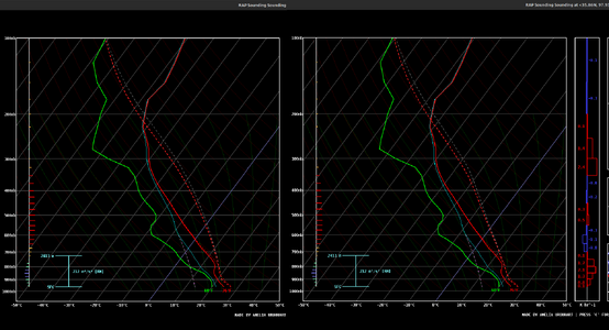
I haven't seen much discussion of it yet, but I think low-level lapse rates could end up limiting tomorrow's tornado potential in Oklahoma. I've been working with some of John Peter's research with parcel entrainment which also accounts for buoyancy reductions through cloud condensate loading, and using it shows a significant reduction in low-level buoyancy. Left skew-T uses pseudoadiabatic ascent (all condensate removed immediately) and right skew-T uses irreversible adiabatic ascent (all condensate retained within parcel).

(Kingfisher, Oklahoma - 00Z - RAP)

1714939503190.png

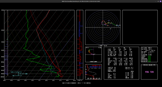
Other NWP is a bit more optimistic, with much less neutral stability in the lower levels.

(Lawton, Oklahoma - 23Z - NAM 3km)

1714940184937.png

I definitely expect to be playing the LLLRs tomorrow more than anything else. I'd worry about precip loading killing all tornado potential in any environment with shallower lapse rates, though it's also worth keeping in mind the potential for local storm-scale environmental modifications and dynamic pressure accelerations from any surface based meso that does manage to get established in such an environment.
 
I've spent the better part of 3 hours on this forecast:


Jeff Piotrowski just pointed out that STL U's #1 analog for tomorrow is 4-26-91 (gasp!). I think it looks like 5-8-03. Both were high risk days.

Be careful tomorrow!
 
Taking a pass on this one although I do see high reward potential, especially in Oklahoma. But unless I’m already out on a trip and Oklahoma is the only good play I won’t chase there, my days of driving out there for a one and done are long gone. That basically leaves Texas or Kansas with Texas not only being a very long drive but having high bust potential. I’d love to redeem myself from my epic failure last weekend (diverted past the big show on 4/26 to better position myself for my 4/27 bust) but I think it’s too likely things go up early in Kansas (18z, before greater destabilization is realized) and go upscale quickly. There may be a small window of opportunity for an isolated cell but the chances for a successful tornado intercept seem low, at least for me personally…and it would likely be an intercept with storms possibly moving at 50+/- mph.

That said, if I were already out there I’d bite the bullet, battle the crowds, face a blue sky bust and chase SW OK. If a storm were to go up it would likely be more isolated in nature, in a more unstable environment (some models depict CAPE well over 4K), be moving at more manageable speeds and have long track isolated potential. I also don’t think the I-35 corridor will come into play, at least during daylight chasing hours. The flies in the ointment for me would be the hordes, bust potential, 2K+ miles and 2 days of lost business. I also think it could get very dangerous, not only does battling the crowds suck but chasing hordes are a ticking time bomb waiting to go off. I also think Kansas will have a high danger potential, to a lesser extent from the crowds (although there will be crowds) but a to a greater extent from the storm mode. I can see ultimately facing an unbroken band of severe cells featuring areas of strong embedded rotation and spitting out up to baseball sized stones.

Regardless the target I hope all chasers stay safe, maintain high levels of awareness, err on the side of caution…and come home with some amazing memories! Good luck all!
 
The elderly meteorologist here... and, I wish to pass along some synoptic climatology info that may be helpful tomorrow.

I keep reading that Kansas won't have major tornadoes because the storms are going to "line out." I don't think the storms will line out until evening, but even if they do, that doesn't prevent strong (≥EF-2) tornadoes from occurring. I have attached the OUN/Twin Lakes radar from Saturday, 27th, as of 10:54pm. There were two strong tornadoes in progress and two others that had tornado warnings. This included the Ardmore and Wewoka area tornadoes.

The second point I wish to make is the fact that, as Jeff Piotrowski and others have pointed out, the analogs for tomorrow are:
  1. April 26, 1991 (F-5 Wichita-Andover, Red Rock, etc., etc.)
  2. May 8, 2003 (F-4 Yates Center, etc.)
Below, you will find the storm reports from those two days. Both were verified as "high risk." And, it was a nearly solid line in eastern Kansas. On the 8th, I intercepted and photographed the F-3 Lyndon-Lawrence Tornado (see below) even as rain from the supercell that produced the Yates Center tornado was falling on me (I was at the circle; tornado the solid arrow)! It was raining so hard, I could hardly see the tornado a mile to my NW. A map is attached. The tornado photo was enhanced by a professional photography lab and that was the best contrast they could get from my 35 mm SLR.

I'll be the very first person to acknowledge the analogues don't always work out and that I may be over-forecasting Monday's tornadoes. But, that doesn't matter much to my primary points:
  • Solid or nearly solid lines can produce strong tornadoes and they can be chased successfully. But they require extra care.
  • Not all "high risk" days are made up of 3-4 supercells equally spread out over a 300 mi N/S corridor.
Good luck and be safe tomorrow!

Mike
 

Attachments

  • Screenshot 2024-05-05 at 6.56.58 PM.png
    Screenshot 2024-05-05 at 6.56.58 PM.png
    3.3 MB · Views: 27
  • Screenshot 2024-05-05 at 7.05.34 PM.png
    Screenshot 2024-05-05 at 7.05.34 PM.png
    366.9 KB · Views: 15
  • Screenshot 2024-05-05 at 7.05.50 PM.png
    Screenshot 2024-05-05 at 7.05.50 PM.png
    379 KB · Views: 14
  • Lyndon-Lawrence Tornado.png
    Lyndon-Lawrence Tornado.png
    348.5 KB · Views: 16
  • Lyndon-Lawrence Tornado Path.png
    Lyndon-Lawrence Tornado Path.png
    2.3 MB · Views: 23
The elderly meteorologist here... and, I wish to pass along some synoptic climatology info that may be helpful tomorrow.

I keep reading that Kansas won't have major tornadoes because the storms are going to "line out." I don't think the storms will line out until evening, but even if they do, that doesn't prevent strong (≥EF-2) tornadoes from occurring. I have attached the OUN/Twin Lakes radar from Saturday, 27th, as of 10:54pm. There were two strong tornadoes in progress and two others that had tornado warnings. This included the Ardmore and Wewoka area tornadoes.

The second point I wish to make is the fact that, as Jeff Piotrowski and others have pointed out, the analogs for tomorrow are:
  1. April 26, 1991 (F-5 Wichita-Andover, Red Rock, etc., etc.)
  2. May 8, 2003 (F-4 Yates Center, etc.)
Below, you will find the storm reports from those two days. Both were verified as "high risk." And, it was a nearly solid line in eastern Kansas. On the 8th, I intercepted and photographed the F-3 Lyndon-Lawrence Tornado (see below) even as rain from the supercell that produced the Yates Center tornado was falling on me! It was raining so hard, I could hardly see the tornado a mile to my NW. A map is attached. The tornado photo was enhanced by a professional photography lab and that was the best contrast they could get from my 35 mm SLR.

I'll be the very first person to acknowledge the analogues don't always work out and that I may be over-forecasting Monday's tornadoes. But, that doesn't matter much to my primary points:
  • Solid or nearly solid lines can produce strong tornadoes and they can be chased successfully. But they require extra care.
  • Not all "high risk" days are made up of 3-4 supercells equally spread out over a 300 mi N/S corridor.
Good luck and be safe tomorrow!

Mike
What are you seeing that suggests the storms in Kansas won't line out until the evening? Everything I'm seeing so far seems to suggest very quick upscale growth (primarily boundary/shear vector angles), but I'm curious what indicators are suggesting otherwise.
 
What are you seeing that suggests the storms in Kansas won't line out until the evening? Everything I'm seeing so far seems to suggest very quick upscale growth (primarily boundary/shear vector angles), but I'm curious what indicators are suggesting otherwise.
Two things:
  • I looked at the 21Z 500mb flow over the dry line location. There is about a 40° angle. That is hardly parallel to the DL.
  • The CAMs this season love to line storms out more quickly than reality. Remember eastern Nebraska on the 26th? Most (not all) of the CAMs had a nearly solid line. I've posted the actual radar here.
 

Attachments

  • Screenshot 2024-05-05 at 7.37.56 PM.png
    Screenshot 2024-05-05 at 7.37.56 PM.png
    1.4 MB · Views: 19
Two things:
  • I looked at the 21Z 500mb flow over the dry line location. There is about a 40° angle. That is hardly parallel to the DL.
  • The CAMs this season love to line storms out more quickly than reality. Remember eastern Nebraska on the 26th? Most (not all) of the CAMs had a nearly solid line. I've posted the actual radar here.

After having looked at it, I definitely agree that Kansas now looks more favorable for discrete convection. Dryline/shear vector orientations now appear to support highly discrete convection at 21Z all the way from southern Oklahoma into southern Nebraska. I've also attached a similar analysis from the NAM initialized at 00Z yesterday, which was informing my earlier statement.

1714956404237.png
 

Attachments

  • 1714956765393.png
    1714956765393.png
    638.7 KB · Views: 17
For anyone that does plan to chase Oklahoma tomorrow... please be aware the area has received plenty of rain over the last week. So if you don't have 4WD vehicle, try to avoid any dirt roads. Situational awareness will definitely need to be a focal point to any chase tomorrow.

Kansas also has a bunch of road construction going on in Wichita and several major highways in South Central and East Central Kansas.

Kandrive will be your friend tomorrow
 
More synoptic climatology: If the 00Z HRRR is correct (a big "if"), isolated/scattered supercells ahead of a line are highly favorable areas for tornadoes, often strong.
 

Attachments

  • Screenshot 2024-05-05 at 8.36.05 PM.png
    Screenshot 2024-05-05 at 8.36.05 PM.png
    571.6 KB · Views: 15
The environment as depicted by the CAMs remains favorable from I-70 to the Red River, with plenty of storms to spread everyone out. In terms of upper flow and anvil-level ventilation, Kansas is shown looking better before sunset (22-00z), while Oklahoma looks better from 00z onward. Faster flow means faster storms though. I'm on my way west out of STL, still holding to my overnight spot in Emporia and will be up at 8AM to evaluate from there.
 
The environment as depicted by the CAMs remains favorable from I-70 to the Red River, with plenty of storms to spread everyone out. In terms of upper flow and anvil-level ventilation, Kansas is shown looking better before sunset (22-00z), while Oklahoma looks better from 00z onward. Faster flow means faster storms though. I'm on my way west out of STL, still holding to my overnight spot in Emporia and will be up at 8AM to evaluate from there.
I've arranged for my chase partner to bring the car to the building my final is being held in to cut down on the time for me to walk to the parking lot. I'm expecting to need to save every possible minute and get west/north of OKC as fast as possible.
 
I've arranged for my chase partner to bring the car to the building my final is being held in to cut down on the time for me to walk to the parking lot. I'm expecting to need to save every possible minute and get west/north of OKC as fast as possible.
During the May 24, 2011 outbreak, the interstates and roads in OKC were basically traffic free from 430pm onward. Most businesses and people left early in preparation of the storms. One can only hope that every takes it as seriously tomorrow and we don't have bumper to bumper rush hour just in case.
 
Yes... i know this sounding is 100% cherry picked, but it is by far the best picked cherry i have ever seen.

NEAR: Red Rock, OK

2024050600_NAM_027_36.49,-97.26_severe_ml.png
 
Interesting evening model runs and analysis. The jet is very visible on water vapor and looks pretty impressive as it rolled past Vegas. The 200 and 300mb charts on the NAM really point me at Central Oklahoma. Should get a highly visible monster with good divergent flow and venting.

200wh.conus.png300wh.conus.png


Dewpoints have been rising and should start to go up as the 70s south of here get pulled north
latest.tdew.png

Could be a long day tomorrow around here. Protip: If you find yourself in Oklahoma chasing, do a seek through the FM stations and find one of the TV station simulcast feeds. Typically you'll find out storm information fast. A lot of newbies here probably don't know about that.
 
Busy workday with an early start as I sit in southeast PA missing another outbreak, so will have to settle for an armchair chase target with information available as of 6am EDT this morning. Thinking roughly Enid OK to Anthony KS. The parameter space is excellent over a large area, but the orientation to the dryline of both the shear vectors and mean steering winds are more favorable as you go south. This area should be in the left exit region of the upper jet, providing additional lift than what may be available further south. Hodographs show some veer/back but I have come to realize that is not the negative it is commonly thought to be. Especially given fast storm motions, probably not as much “room” to work with before I-35 as I was thinking a day or two ago, and the Wichita area will be no less of a zoo than the OKC area, so be safe everyone and take note of the heads up from @J Holder on KS road construction.

EDIT: Also thinking that if the KS activity quickly goes linear, this proposed target area may still provide the opportunity for a tail-end Charlie.
 
Last edited:
In case this hasn't been seen.

The 12Z HRRR forecast for 5pm (and this was true of the previous run) has isolated supercells ahead of the line. From a synoptic climatology PoV, these are highly favored to produce strong tornadoes.

In my opinion these storms, with the line immediately to the west, are too dangerous to chase (yes, I know you have the Dominator, Reed 😊).
 

Attachments

  • Screenshot 2024-05-06 at 7.25.52 AM.png
    Screenshot 2024-05-06 at 7.25.52 AM.png
    523.9 KB · Views: 16
  • Screenshot 2024-05-06 at 8.13.20 AM.png
    Screenshot 2024-05-06 at 8.13.20 AM.png
    339.9 KB · Views: 14
Last edited:
In case this hasn't been seen.

The 12Z HRRR forecast for 5pm (and this was true of the previous run) has isolated supercells ahead of the line. From a synoptic climatology PoV, these are highly favored to produce strong tornadoes.

In my opinion these storms, with the line immediately to the west, are too dangerous to chase (yes, I know you have the Dominator, Reed 😊).
NWS Topeka thinks the storms ahead of the line are unlikely due to:
1. Capping Under stratus
2. Co-location of forcing with the front.
However, if one goes I agree with the assessment it would be a very bad scenario for people in the path.

Driving into work this morning it was heavy fog/drizzle and I couldn't help but think about the conversations on here in regards to morning precip and strong tornadoes.
 
NWS Topeka thinks the storms ahead of the line are unlikely due to:
1. Capping Under stratus
2. Co-location of forcing with the front.
However, if one goes I agree with the assessment it would be a very bad scenario for people in the path.
I agree for the TOP CWA, but the high risk in in the ICT, OUN, and, to an extent, the TUL CWA's.
 
Back
Top