-
While Stormtrack has discontinued its hosting of SpotterNetwork support on the forums, keep in mind that support for SpotterNetwork issues is available by emailing [email protected].
You are using an out of date browser. It may not display this or other websites correctly.
You should upgrade or use an alternative browser.
You should upgrade or use an alternative browser.
State of the Chase Season 2023
- Thread starter adlyons
- Start date
- Status
- Not open for further replies.
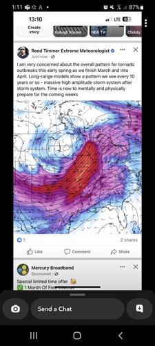
Reed Timmer has lost most of his credibility with me. Unless he has calmed down over the past few years...he thinks everything is the worst thing we've ever seen.
I would think if he was trying to be serious about discussing a pattern beyond the medium range, he would be showing tools that reflect those forecasts rather than one deterministic model's output at a time that shows a trough.
Here's a good example: https://atlas.niu.edu/forecast/scp/gefs_scp_stda_chiclet.png
Matt Zumbrunn
EF2
Ive been sent that screen shot by 2 different family members. Whether that factually or not remains to be seen. I am not nearly as bullish. I would take rain over a large portion of the state however.
Andy Wehrle
EF5
Reed Timmer has lost most of his credibility with me. Unless he has calmed down over the past few years...he thinks everything is the worst thing we've ever seen.
I would think if he was trying to be serious about discussing a pattern beyond the medium range, he would be showing tools that reflect those forecasts rather than one deterministic model's output at a time that shows a trough.
Here's a good example: https://atlas.niu.edu/forecast/scp/gefs_scp_stda_chiclet.png
Reed never met a marginal risk that wasn't the mother of all outbreaks, lol. So I agree that doesn't mean much, even though he's not wrong in that the deterministic models do seem to agree on an active pattern forthcoming. Much remains to be sorted out, but it's better than a giant desert Death Ridge or endless series of Arctic highs pouring cold air into the eastern half of the country.
Recent years have not been kind to chasers who have stuck by the old "wait for May" adage, so I strongly recommend to chase the setups as they present themselves if you have the means to do so.
JamesCaruso
Staff member
I would think if he was trying to be serious about discussing a pattern beyond the medium range, he would be showing tools that reflect those forecasts rather than one deterministic model's output at a time that shows a trough.
Not only does he show just “one deterministic model's output at a time that shows a trough,” but it doesn’t even show the valid date/time!
And no, he has not calmed down, I won’t even watch his videos anymore after listening to him screaming in last year’s Andover tornado and Friday’s Rolling Fork tornado.
Jason N
EF5
it's a shame in a sense, he's obviously intelligent and backed by his educational foundations, but you add in hype and TV, and it turns people into something else (someone else). Every chase is a potential highlight reel on the weather channel or discovery. Sadly I think a lot of chasers have take hold of this model and have done it for themselves on their own channels. I will say that at least for Rolling Fork, he still shows the compassion to take injured people to the hospital. Which was a good thing.
Jeff House
Supporter
End of this week looks like another severe wx setup, but it looks like most other late March setups. Seems fine to discuss it but not as anything special (at Day 4). Could trend up; could stay the same.
The broad pattern is there on Friday for parts of the Mississippi River Valley and Ozarks. Southwest flow, deepening surface low, moisture return, and robust winds turning with height are pattern recognition signatures. Surface boundaries, other precipitation, and storm mode are paramount to chasers, and it's too soon to determine such details.
Persistent trough out West and southwest flow into next week could offer additional chance(s). Looking out 7-10 days it becomes very broad though. Could be Plains. Could be Mid-South or even elsewhere.
Matt Zumbrunn
EF2
Amazing how a week out thursday looked very interesting, and basically every model run since then the chance of even getting precip has shrunk.
Jeff House
Supporter
The Plains is pretty fickle early season (March). Once in a while Hesston happens. Most of the time, the above happens. Systems have not fully developed, and quite related moisture is sparse.
Setups tend to fully come together Mid-South early season, sometimes Midwest (east of the Plains). April is getting into Plains time. Next week could be a chance Plains, but early April is also still Mid-South season.
Setups tend to fully come together Mid-South early season, sometimes Midwest (east of the Plains). April is getting into Plains time. Next week could be a chance Plains, but early April is also still Mid-South season.
Matt Zumbrunn
EF2
Jason N
EF5
Adlyons -
NAM seems to be homing in on SE MO / CNTRL-SRN IL for best Tornado probs at the moment, but it appears with the flow patterns and Hodo, that any initial discrete looks to get overtaken by a pretty intense QLCS bow with embedded SC spin-ups it looks like. It appears it could turn into a pretty significant wind event in NRN IL / SRN WS. So, I don't know if you're going to get your numbers, but you never know. The day prior looks like it doesn't help you much, as the best dynamics don't look to time out properly over NE/KS/OK.
NAM seems to be homing in on SE MO / CNTRL-SRN IL for best Tornado probs at the moment, but it appears with the flow patterns and Hodo, that any initial discrete looks to get overtaken by a pretty intense QLCS bow with embedded SC spin-ups it looks like. It appears it could turn into a pretty significant wind event in NRN IL / SRN WS. So, I don't know if you're going to get your numbers, but you never know. The day prior looks like it doesn't help you much, as the best dynamics don't look to time out properly over NE/KS/OK.
Jeff S
Enthusiast
You also can't rule out those storms pushing into western Kentucky and Tennessee going into the evening, late evening and overnight when it moves into the central parts of those states. Unless there's some convergence with that northern squall line, eastern Arkansas and northwestern Mississippi has the best chance for isolated supercells going into that night. That's what I gather from NAM atm.Adlyons -
NAM seems to be homing in on SE MO / CNTRL-SRN IL for best Tornado probs at the moment.
john heyden
EF0
It still seems to be chances next friday, personaly i rather have the enhanched area more to the west to the region of Tornado Alley...
Potentially intense and widespread severe thunderstorms are expected
Friday afternoon into the overnight hours across portions of the
Middle Mississippi Valley and Mid-South vicinity, eastward to the
Lower Ohio and Tennessee Valleys. Damaging gusts and tornadoes will
be the main hazards with this activity.
Jason N
EF5
One Thing I noticed looking a little further out into April was the NAO/PNA/MJO patterns/phases. MJO looks to be moving into phase 6/7 by week 3 while NAO/PNA remain neutral to slight negative. should keep things a bit more active across Ern Half of the US through April. guess we'll see how that pans out.
Staff Note
Mmmmkay, everyone. We're starting to get a lot of off-topic posts in this thread. This thread is must remain germane to overall seasonal outlooks and activity, and separated from specific discussion about individual events. Use the Target Area sub-forum for discussion of particular events such as 31 March (today).
Mmmmkay, everyone. We're starting to get a lot of off-topic posts in this thread. This thread is must remain germane to overall seasonal outlooks and activity, and separated from specific discussion about individual events. Use the Target Area sub-forum for discussion of particular events such as 31 March (today).
- Status
- Not open for further replies.
Similar threads
- Replies
- 74
- Views
- 9K
- Replies
- 8
- Views
- 2K
- Replies
- 59
- Views
- 10K
- Replies
- 250
- Views
- 45K


