State of the Chase Season 2022

Anything in SW NM into the LBB / MAF region will be a long shot on Monday and Tuesday. It's a very complicated forecast involving fronts, RH distribution, outflows and cloud cover. It could turn into a pea-soup, heavy rain event with embedded SVR cells. I'm not sure any chase-worthy possibilities will be apparent until Monday AM. I'm already in the region (AMA) as it's the only game in the near future, until maybe late next week.
 
It's still in fantasy range one way or the other, but it's still demoralizing to take soundings from that area of >6 EHI and >400 m2/s2 3KM SRH in northeastern SD at FH156 on the 12Z GFS and the best we can do is a "marginal" TOR hazard type due to capping issues.
 
It's still in fantasy range one way or the other, but it's still demoralizing to take soundings from that area of >6 EHI and >400 m2/s2 3KM SRH in northeastern SD at FH156 on the 12Z GFS and the best we can do is a "marginal" TOR hazard type due to capping issues.
Anecdotally speaking, the cap has been batting close to 1.0 in borderline situations this spring on the C/S Plains. Yesterday afternoon in OK and N TX was a perfect example, where the majority of guidance -- including the ECMWF -- insisted on widespread CI along the cold front by 6-7p. In reality, there was essentially nothing, even by 9p. A few days earlier on May 17, the potent but conditional setup in S KS also failed to initiate at all, despite ECMWF deterministic and ensemble guidance painting a robust area of >0.1" QPF between 18-00z that afternoon... on run after run. Even going back to March and April, including the Gilmore City IA and Andover KS days, "conditional CI on the dryline" has usually equated to "forget about it." To the extent that this reflects a seasonal bias arising from systematic errors in lower boundary conditions and/or initial atmospheric conditions somewhere upstream, it's definitely something to watch out for going forward. This may be especially relevant with any setups late next week into Memorial Day, since there's likely to be a preceding disruption in moisture quality that will take a few days of return flow to sort out.
 
Moisture/capping issues aside, there is still no sign of insta death ridge like we've had the last few years by this time.

Wavy zonal still can get the job done. Lots of uncertainty going forward here in model land and how moisture return shakes out. But...the jet isn't jumping into Canada yet.

Central/Northern plains and Memorial Day weekend time frame are historically pretty good. For once I am actually going to have some time off first week of June this year and it looks like it certainly will have possibilities up here.

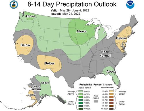
814prcp.new (4).gif
 
My bushes collapsed under the weight of the snow last night. I'd get photos of all of the downed trees all over town, but I'm on baby duty. Hopefully this moisture can make its way east out of Colorado and help out this chase season a little.

Arrived in DEN earlier today and drove down to Colorado Springs. I don’t necessarily use DEN as my jumping off point every year, but going back to 1996 when I started chasing I can’t say I remember ever having cold and snow in this area this late in the spring… I’m no expert on Colorado climatology, but this has to be very, very rare, correct?

OT but it was nice to be back in winter for a day, especially with my home town near Philadelphia soaring into the 90’s today! It was a treat to walk around Garden of the Gods among the snow-covered trees, quite refreshing in the upper 30s, felt like Christmas!
 
It's still in fantasy range one way or the other, but it's still demoralizing to take soundings from that area of >6 EHI and >400 m2/s2 3KM SRH in northeastern SD at FH156 on the 12Z GFS and the best we can do is a "marginal" TOR hazard type due to capping issues.

FWIW, over the years I've noticed the long-range models will often show a strong cap. I wouldn't worry about it too much until it's within range of the NAM. When I'm looking long-range, I'm primarily looking to see if there will be a trough. If there is, there's a chance, but it's no guarantee unless all those other features come together as well. But of course, as Brett mentioned, it wouldn't be all that surprising after moisture has been completely wiped out of the Plains, which is pretty rare for this late in the season. It's been a weird spring-summer-winter-spring.
 
Landed in Dallas from Sydney , Australia late Sat afternoon. Haven't been able to get over the last couple of years. I am going to play in the Tex panhandle on monday afternoon. I would be guessing with the drought conditions that a bit of a haboob might be on the cards. HRRR and NAMNEST have plenty activity though nothing particularly decent on the helicity tracks. im here for a couple weeks so ill take everything offered. Im not really a fan of chasing the hill country in far south Texas unless desperate so ill ignore the slight zone.
Awesome to be back for my 7th US chase.
 
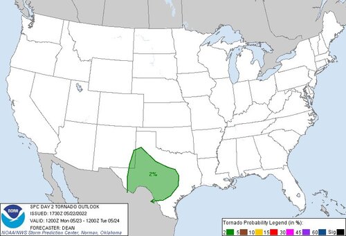
Classic, nothing to something, west Texas sneak attack for 5-23-22 verified by RAP and now SPC. Would not be surprised if risk levels were raised. Tuesday and Wednesday's action (if any) will depend a lot on outflows. As others have noted, end of May and first part of June has promise.
 

Attachments

  • FTYYcElUEAAryWD.jpg
    FTYYcElUEAAryWD.jpg
    68.2 KB · Views: 0
Alright, I think I'm finally settled on leaving Tuesday for Texas so that I can get staged for Wednesday. Now that Wednesday is in the NAM range, I feel confident with chasing Wednesday. I'm targeting Waco right now, but that'll probably change slightly as we get closer. I'm concerned that this might just turn into a hail event. The CAPE is a little low, and that shows up in the sounding, but hopefully it improves a little more between now and Wednesday. Plenty of moisture with RH at 99% and shear in the 55 - 60kt range. CAPE is only around 3,000 right now, but if that increases, it could be a great chase day.
 
Classic, nothing to something, west Texas sneak attack for 5-23-22 verified by RAP and now SPC. Would not be surprised if risk levels were raised. Tuesday and Wednesday's action (if any) will depend a lot on outflows. As others have noted, end of May and first part of June has promise.

I had been watching the TX/NM border area more so than central TX. My concerns were the lack of more robust moisture (I know it's higher elevation and won't require as much), CAPE struggling to top 1000 J/kg, and shear isn't spectacular. With the extreme drought, there's no ground moisture to help bump those dews up, and I'm not seeing a strong LLJ bringing it in. Of course now that I've made up my mind not to go, I'm trying to find all the reasons it WON'T happen, haha! What are the positives that you're seeing with this setup? If Dora 2.0 happens I'll surely be banging my head against the wall.
 
Classic, nothing to something, west Texas sneak attack for 5-23-22 verified by RAP and now SPC. Would not be surprised if risk levels were raised. Tuesday and Wednesday's action (if any) will depend a lot on outflows. As others have noted, end of May and first part of June has promise.

Awesome to see this Warren, as I am en route from Colorado Springs to Amarillo. Last time I looked at any data was 7:30am MDT this morning - 06Z models from last night - and was surprised SPC had the area I have been eyeing for days only in a General Thunderstorm risk and talking only about the region further east in TX… I was able to get a marginal TOR sounding near the NM/TX near Hobbs or Jal (and even one up west of LBB).

AMA is a bit out of the way to set up, but I don’t want to commit too much yet today, and wanted to show my son where it all began for me - Marty Feeley used to start his tours out of Amarillo when I started chasing with him in 1996.
 
Good luck to all who traveled far, from the East Coast, from Australia! Everywhere else too.

I'm sensing a Northern Plans sequence starting about Sunday. Could go through Tuesday gradually sagging into the Central Plains. Some risk of a progressive trough and only a couple good days. Upside is 4 gems if Sat-Tue or Sun-Wed - earlier probably more likely if it happens, but we are several days out.

MJO and Pac jet extension behavior support a new trough into the US West. Might not dig all the way into the Rockies; so, I'm not too excited about southern Plains, plus cap. However the northern half should get something out of it.
 
i‘m planning on being out, but the GFS is really struggling to let the cap be broke Saturday-Monday. I think everything will work out just fine. Monday is looking like the best day (yes, I know we’re a week out and it will change) with the moisture solidly in place, surface and mid-level winds looking good, lapse rates and helicity all up there as a trough moves through Southern Kansas. Fingers crossed…..
 
I'm feeling optimistic about the weekend and next week, in spite of the concerns of the cap. 12z GFS does show some areas of weaker cap, particularly in the northern plains, closer to the heart of the trough. Nonetheless, the details can and will change, but on the larger scale, models have been pretty consistent, and in pretty good agreement about consecutive days with a trough over the northern/central plains. We oughtta be able to eek out a couple good days through that time period. 12z Euro shows pretty weak shear on Saturday, but theta-E above 360°K throughout much of Nebraska, with better shear arriving Sunday & Monday.
 
I'm feeling optimistic about the weekend and next week, in spite of the concerns of the cap. 12z GFS does show some areas of weaker cap, particularly in the northern plains, closer to the heart of the trough. Nonetheless, the details can and will change, but on the larger scale, models have been pretty consistent, and in pretty good agreement about consecutive days with a trough over the northern/central plains. We oughtta be able to eek out a couple good days through that time period. 12z Euro shows pretty weak shear on Saturday, but theta-E above 360°K throughout much of Nebraska, with better shear arriving Sunday & Monday.

I agree the models are becoming more settled with a trough or two and some short wave potential, a reason to at least hope one or two days works out.

I'm much more worried about continued lack of reasonable moisture (both surface and deep) than troughing at this point. I've only been at this hobby just over a decade so maybe this is only new for me, but I cannot ever recall seeing moisture so far east consistently, many drylines non existent or oriented practically horizontal or mix out, moisture replenishment/return very weak between events, etc. It seems like every time there is sufficient shear the good moisture is 200 miles away, etc. Giant haboobs in the dust bowl counties for the first time in a long while.

I used to assume based upon experience that moisture was generally laying around somewhere in the plains (at least in May) and start my forecasts looking for troughing to spot long range opportunities. Now I go out to model extents hoping for significant moisture to be forecast west of the Mississippi any time in the rest of my life.

To me it looks like the couple marginal setups in TX today and tomorrow, and then no moisture under shear until maybe 5/29 (briefly for maybe a day or two in parts of NE/IA, in a narrow band of overlap according to latest GFS). While longer range GFS is mostly useless to me, the run trend has not been getting better for consistent moisture return even into first week of June. Hoping things will change as end of May and beginning of June get nearer. I'd take a good local storm with lightning at this point.
 
Back
Top