• A friendly and periodic reminder of the rules we use for fostering high SNR and quality conversation and interaction at Stormtrack: Forum rules

    P.S. - Nothing specific happened to prompt this message! No one is in trouble, there are no flame wars in effect, nor any inappropriate conversation ongoing. This is being posted sitewide as a casual refresher.

State of the Chase Season 2022

In Salina KS this morning, having gradually made our way north from Odessa where we were Tuesday night. Woke up thinking I probably should get all the way up to around Valentine today to be in range of SD for Saturday. But I am no longer focused on SD for Saturday. SPC doesn’t even mention supercells, tornado risk is <2%, and NAM (which usually over does moisture) does not even get 60s dews much into SD; Euro concurs, with only the GFS being aggressive in that regard (this is per last night’s 6z models, except 0z Euro). North Platte AFD is a bit more bullish on supercells along the dryline in Nebraska for Saturday. Going to head to Kearney today to set up for tomorrow; SD still reachable if it becomes necessary.

Taking it one day at a time with model analysis, but based on SPC outlooks I’m hoping I can stay in Nebraska for Sunday and not have to venture into Minnesota or anything like that… Monday is a similar area but hoping the Kansas portion of the Day 4 outlook pans out as I like chasing there and it gets us back south for potential opportunities beyond that.
 
Today's 12Z NAM offers a little hope for the cap to break Sunday evening, mainly in central Kansas and possibly in central Iowa (near Winterset!). Soundings still have some capping but at least not so much they put "NONE" in the hazard type box despite plentiful instability and classic shear profiles.

nam_2022052712_060_41.6--94.11.png
 
Sunday and Monday are clear eastern ND and western Minn. Checks air fare to MSP. Details 3rd paragraph.

First Saturday, I would target just behind the boundary intersection near the Black Hills. Roads are not ideal, but terrain can help even if the SPC fades the set-up. Black Hills are behind the cap (good) - and boundaries (meh) so, it is a pure terrain play.

Sun/Mon both feature double short waves and double surface responses. Yes 3-4 days out, but models are not going to blow that basic type of forecast. Trouble is northern waves drag up warm 850 Ts ahead of southern waves. Gosh, like forecasting snow busts in the South!

OK back to the Plains. Nebraska gets boundary intersections. Excellent CAPE is under worst cap. Easier cap is right on or behind boundaries. You know, I don't like right on boundary initiation any better than just-in-time moisture.

Eastern North Dakota and Minnesota enjoy a better set-up IMHO Sun/Mon. Frontal waves and perhaps warm front intersection with more traditional boundaries. Less cap. Still good CAPE. Said boundaries promote local SRH.

Tuesday (or as early as Monday NE) could still go Nebraska Kansas, but LLJ moves out as main trough ejects. That's faster for Tuesday, and takes away a solid chase day.

Bottom line: Sunday and Monday look like the kind of days that can work out eastern ND western Minn. Saturday junk will deposit other boundaries for Sunday. Rinse and repeat Mon. Maybe Tue.
 
Actually, now that I look at it the greatest threat Monday appears to be closer to the Canadian border than I'd like...I mainly remember 6/17/10 for the Albert Lea tornado that a lot of well-known chasers were on, although there were significant/some violent tornadoes much further north in that area of eastern ND/far NW MN.

Sunday and Monday are getting close enough that it's probably time to start TA threads for them, if anyone cares to (or just discuss in Discord).

More for the actual daily forecast thread, but the GFS-and now EURO, are also coming in HOT for Monday and have surface features in the climatologically expected position for 95% of our events up here. Been doing this asinine hobby for 15 years and while nothing is a guarantee this is as close as it gets. Think Interstate 94 and towns like Willmar, Alexandria on up to Fargo at go time.

Sorry if this belongs on a forecast thread. I'm still picking my jaw up off the floor after both nam and gfs runs.
 
Last edited:
Maybe it's just because chasing has made me a pessimist over the last decade, but I would caution everyone currently creaming themselves over Monday. A brief glance shows nice parameters when time is frozen, but if you look at the difference between 21Z and OZ on the 30th you'll see that the surface features are FLYING at about 60 mph to the northeast. Given the road network and swampland of that area of the country, you better hope those features move far to the southwest and slow down to about half of what they're showing. Otherwise you're gonna have to pull up a chair at a lake in Minnesota and hope one of the cells has a tornado on it as it flies past you at Mach 2.5.
 
Maybe it's just because chasing has made me a pessimist over the last decade, but I would caution everyone currently creaming themselves over Monday. A brief glance shows nice parameters when time is frozen, but if you look at the difference between 21Z and OZ on the 30th you'll see that the surface features are FLYING at about 60 mph to the northeast. Given the road network and swampland of that area of the country, you better hope those features move far to the southwest and slow down to about half of what they're showing. Otherwise you're gonna have to pull up a chair at a lake in Minnesota and hope one of the cells has a tornado on it as it flies past you at Mach 2.5.

You'll have to forgive us. Lack of anything for the past umpteen years up here has us jaded and desperate.

That being said no model is as extreme north as the nam and we hug the model that shows us the best scenario until all hope is gone. 🤣 Let me have my moment and then reality will sink in.
 
I really want to head out to the Dakotas for the next targets but after my Southern Plains chase a few weeks ago (3k mi driving o_O) , I am not sure if i want to drive 12+hrs and fight Memorial Day traffic. I may just sit out the weekend and target/wish/hope early June for Northern Plains serves up. But...if someone here can guarantee me a good solid week...i am gone....Anyone :rolleyes::rolleyes::rolleyes:
I can guarantee a solid week! A week out chasing is solidly better than hanging around the house thinking about what awaits you on the open road😁
 
I've only got two days of chasing left, and I have to be back in Colorado Monday night. So you all enjoy those Canadian Tornados. I'm chasing Northwest Kansas / South Nebraska on Saturday, and Eastern Nebraska on Sunday.

I originally was thinking about Northern Oklahoma or Southern Kansas for Saturday. That was until I saw Jeff's post about the cap, and looked for myself. CIN is like -400, making that 4000 CAPE worthless. 🤮
 
Oh Monday you should find a way, even with lots of coffee. However safety is always first!

I will try to post in Target Area each morning. However during the afternoons, I will switch to chase mode on Storm Track Discord. It's quicker.

Since I'm flying, so my partner is driving, I can try to nowcast safely on Discord. Good luck to all. Chase safely!
 
Andy is correct. So far this year the northern plains have had two different longer-wave troughs eject over the course of multiple days and it hasn't yielded a single notable tornado, or even supercell. Virtually everything this time of year through August is an MCS, if anything. Count me in the camp of 'I'll believe it when I see it'.
In the hopes of possibly reverse jinxing this, I'd say today looks about the same. 98% chance of a bust.
 
Least we are in the above normal precipitation, not liking the below normal temperatures again. On the positive though, my local area (KDVN), on my Facebook, the memories from 1 year ago popped up. It showed that at this point we had only seen 1 TOR warning and 2 SVR warnings the entire CWA and this year we are far ahead of that. Last year turned out very good locally, so there is some hope there. I had planned to take a chase trip last week, but basically just ended up chasing Monday's bust in Northeast Kansas (I didn't like Minnesota's set up at all) and then come home and snagged a multi-vortex tornado a few miles from my apartment late at night.

Not the worst year, but also far far from the best. And now with gas at 5.09-5.29 locally, it will most likely be a local chase mode for the rest of this season.
 
Nothing but northwest flow events, high plains magic for June. Oh how the tables turn.


View attachment 22854

View attachment 22855
My chase vacation starts in the middle of next week and this is what I was hoping wouldn’t happen. Don’t get me wrong, it could be worse, we could have a death ridge with no signs of any storms anywhere on the plains. At least we’re likely to get some high-based stuff coming off the higher terrain, which can be pretty fun. But I’m a little bummed that I probably won’t be chasing any days with good tornado chances.
 
My chase vacation is coming to an end. I have to be back at work on Monday. I normally don’t book my flight home until the end of the trip so that I can be flexible. Obviously to be at work on Monday, I don’t need to fly home until Sunday, but I do like to have a “buffer day” at home between chase vacation and back-to-work… So I am biased toward flying home Saturday and not chasing that day… I didn’t even do much analysis for Saturday, but based on SPC Day 3 and a very quick look at moisture and 500mb, I don’t think I would be missing much…

Considered flying home on Friday - a full weekend “buffer” is even better - but figured I would take a chance on some SE Colorado upslope tomorrow and then fly out of DEN on Saturday… Not too optimistic about tomorrow, but my son is very much enjoying his first trip out here, and I didn’t have the heart to tell him we are going home tomorrow, it seems too much an abrupt end to the trip, and didn’t necessarily fully take in that “this is our last chase until next year” moment while chasing yesterday’s storms near Jal NM and into Andrews County TX (although, maybe consciously thinking that actually prevents one from fully taking in the moment… but that’s a topic for another thread LOL).

In Lubbock this morning and will migrate north by this evening to some point TBD.
 
My chase vacation starts in the middle of next week and this is what I was hoping wouldn’t happen. Don’t get me wrong, it could be worse, we could have a death ridge with no signs of any storms anywhere on the plains. At least we’re likely to get some high-based stuff coming off the higher terrain, which can be pretty fun. But I’m a little bummed that I probably won’t be chasing any days with good tornado chances.

It's a whole heck of a lot better than insta death ridge that we have seen so much the past several years. Colorado hardly ever disappoints in this kind of pattern whether it be structure or even good tornado days. I really wish I could afford the gas this year. But it looks like it will be local chasing for this guy for the rest of the season. And by local, I mean LOCAL. Lol.
 
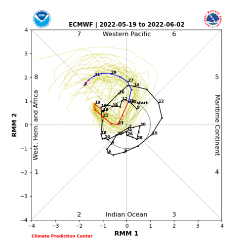
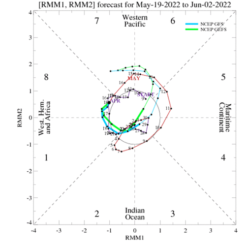
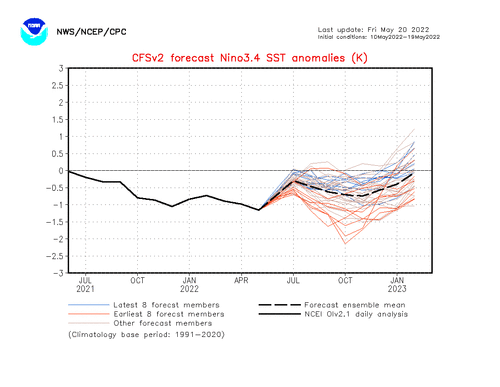
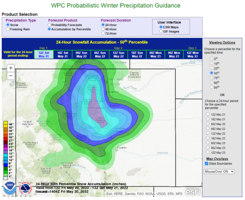
Looking at the ensemble forecast products and a few other things, it would appear the SW flow, SP season will come to an end early next week. Still some opportunities for NW flow events at some point, but not worth waiting it out given the low-preforming season so far. This on top of smoke and dust issues. Time to focus on the SW Monsoon / Haboob season in 3-4 weeks and the hurricane season which should be interesting given another year of weak westerly flow.
 
It's a whole heck of a lot better than insta death ridge that we have seen so much the past several years. Colorado hardly ever disappoints in this kind of pattern whether it be structure or even good tornado days. I really wish I could afford the gas this year. But it looks like it will be local chasing for this guy for the rest of the season. And by local, I mean LOCAL. Lol.
Yeah the high plains can often produce something decent on even MRGL days. I’ve chased some pretty storms with dews in the mid 40s before. Just gotta hope this NW flow pattern can yield something really good.
 
Safe to say that was a very underwhelming month of May. Debating taking a later chasecation next year in mid-June and hope for some Northern Plains action, but that hasn't really been happening in recent years, either. What is the deal? It seems like we haven't seen a truly active severe weather season in years! While there have been some good one-off events, they've mainly been localized events, not the outbreaks that I feel like used to happen several times per year.
 
Ugh.....guess pool season starts early this year. That is if it ever decides to quit raining and stay hot here in IA/IL. Hoping somehow for a miracle in mid-late June or even July this year. Definitely not a year without spectacles to behold, but one that has been exceedingly difficult to forecast even up until 12-24 hours of the event.

Is it too soon to already just be done with it and ready for next year? lol.
 
Back
Top