• A friendly and periodic reminder of the rules we use for fostering high SNR and quality conversation and interaction at Stormtrack: Forum rules

    P.S. - Nothing specific happened to prompt this message! No one is in trouble, there are no flame wars in effect, nor any inappropriate conversation ongoing. This is being posted sitewide as a casual refresher.

State of the Chase Season 2022

adlyons

EF2
Joined
Feb 16, 2014
Messages
167
Location
Norman, Oklahoma
Hey everybody, I figured id get the ball rolling with the 2022 State of the Chase Season thread given we are now at 2 weeks since the new year. Hoping to see a repeat of last years awesome discussion with a few seasonal forecasts thrown in! I wanted to touch on some verification for my seasonal forecast last year. Here is my post from March 1st last year.


Well, happy spring everyone! It being the start of traditional chase season I feel confident enough to lock in a forecast.

Forecast 20201 Tornado Season (MAMJ) :

Counts: Average (754 tornadoes across the CONUS during spring, 1250 plus or minus 50 for the year)
I feel fairly confident on average numbers for the chase season and year. With a moderate La Nina, but complicating factors such as drought, I think we see pretty normal activity. This activity should pick up fairly quickly here over the next two weeks with the first hints of the spring pattern shaping up. Some killers for this would be an early northward retreat of the jet (Aka Death Ridge) cutting into numbers early. This is a distinct possibility given the ongoing drought. A second, perhaps better for us failure mode would be a weak resurgent la nina. This could throw out some higher tornado numbers, though I think this is less likely. Its about 50/50 which side of the coin we end up on, which means I'm going to hedge to average.

Outbreak Days (10+ Tornadoes within 6 hours): Above Average
Its an emerging trend, fewer tornado days, but more tornadoes per day. Im sticking with that. You can define outbreaks in many ways so I'll have to run some stats to verify, but I think we see a more active outbreak pattern going into April and a few very big count days. The forecast is also calling for an above-normal hurricane year. I think we see another active TC tornado year this summer and fall.

Number of EF2+ tornadoes: Well Above Average (Greater than 1 STD above the normal mean)
Im taking a bit of a risk on this one but, with the southeast and eastern half (more populated) of tornado Alley looking more favorable, I'm leaning towards a much higher count of sig tors for the simple fact I expect more of them to hit things. The same trend will probably hold for fatalities.

Chasabillity Score: Average 6/10
My completely scientific and no non-sense chasing index, just kidding it's entirely arbitrary. Not a great year, not a bad year, somewhere right in the middle with a bit more chasing potential. We probably won't be chasing west of I-35 as much as we would like putting a dent into the chaseabillity of some systems, but the average counts combined with a few bigger days will get peoples chasing counts up. Midwestern gang and the southeast should have a decent year. Southern and central plains also won't have much to complain about. Perhaps not the best for the front range and Texas Panhandle guys and gals but a few days spark off. A banner year for a few, but sufficient for most.

We will see where we go from here. Good luck to everyone, stay safe and happy hunting!


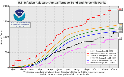
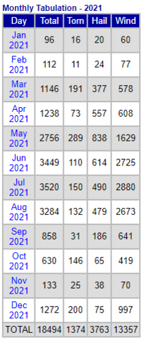
A couple of points. Overall my yearly number prediction was pretty darn close. I predicted just below average on the annual inflation adjusted count and was darn close with the year end reports falling just 30 shy of my bottom end (1250 plus or minus 50). My big miss was the fact that April was very quiet and October and December ended up saving the average!
1642179454266.png
As for my spring count estimate (754), I fell a bit short with only 703 tornadoes being recorded between March and June. As mentioned, April was unusually slow this year with only 73 reported tornadoes. But again, not terrible with how things ended up.
1642179803335.png
Moving on to the outbreak Days, I'm still working on some verification metrics for this. It appears as though there were much fewer outbreak days but the few outbreaks we did have were sizeable. This is a known trend with tornadoes as of late and something I need to look at further. For now I'm going to assign a fail to this part of the forecast as I suggested things would be more active than they appeared to be. And several key outbreaks occurred well into the cool season outside of the time range I was really shooting for. I did make explicitly mention for the threat for several outbreaks associated with land falling TCs, this appears to have gone well with several big days happening across the Mid Atlantic.

Now to EF2+ tornadoes, Again, still working on some verification metrics for the counts of EF2+ but subjective interpretation says I did okay in this regard. The big outbreak days we did have produced quite a few sig tors. We also had the most fatalities since 2011 so that fits with the well above average forecast. I was expecting more during the spring when the December events ended up contributing to most of those. I need to work on some plots since the sig tor data isn't readily available.

Totally objective chaseability score wise I'm going to assign a hit to this for now. It seems like people who were able to get out did have an okay year. I do suspect however the objective metrics will be much lower across the plains when that data is run by Brett. The lack-luster April and only average May/June likely wont compensate for each other and I'm betting its a below average year. Subjectively there were some good tornado days as always. I did pretty poorly but most of that was beyond my control having to limit my chases. I did break my personal 4 year tornado drought in October in Southwest Oklahoma which feels good.

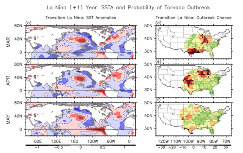
Now looking ahead, I'm seeing a fair amount of the same signals that we saw last year hinting that this year could again be a mixed bag. The big difference looks to be in the way ENSO is expected to evolve through the spring. While we did expect a weakening of la Nina last year, El Niño chances were much lower than this year with CPC calling for 60% chance of EL Nino development by summer/Fall this year. As I mentioned last year, positive TNI events (typical of Nina-Nino transitions) can result in active stretches particularly in the Midwest and southeastern US. Another big factor is the ongoing drought across the western US. How this impacts things is yet to be seen. I suspect the overall impact will be negative on the Plains at least through the early parts of the season. My current gut forecast is calling for an active year east of I-35 but the potential for lower counts in the Plains through spring again. I think things will heat up early season (Mar/April) again as la Nina continues to decay. (Western Gulf Coast southeast and Midwest) April in particular looks interesting. Positive TNI events can result in a significant uptick in probabilities for large outbreaks near and even west of I-35 in April. The GOM is quite warm and should remain so through the spring which is a positive sign for higher than average moisture flux and buoyancy. But, the signal for anything specific really drops off into May. If I had to guess, id expect a below average May this year with concerns about the ongoing drought the potential for El Niño to rapidly develop shifting ridging over the Plains. All in all though kind of a crapshoot this year. By March 1st we should have a much better idea of how things are shaping up. If you're planning a chase cation, I wouldn't stray from the traditional times as statistically its still your best bet. But, if you have the potential to chase earlier in the year pay attention in March and April in particular.
1642182430567.png
Curious on everyone else's thoughts?
 
With how gas prices sit these days, I'm definitely delighted to see some signals for Midwest events. I will probably be doing a lot of local (less than 5 hour one way) chasing this year similar to the last couple years. Especially as well with the pandemic still running rampant. Probably will still take our annual chasecation in late May, but we don't usually figure those days out until a few weeks before. Hopefully its a good year for everyone on here!
 
I am probably going to set my chase vacation for May 21 - June 4. I started a new job less than a year ago and I don’t think I’m going to have my usual flexibility to shift by a week dependent upon weather patterns, so I’ll stick with this climatological peak. Also enables me to get past a monthly financial reporting deadline I am responsible for, although I would have to accelerate it by a couple days and/or review stuff from the road (but I do some remote work every chase vacation anyway).

Biggest thing for me this year is that I am taking my son with me for the first time! School always went until mid/late June around here, so I was never able to take him. Now he is in college, and will be out for the semester by May 15. I am really hoping for an active season - and some good personal forecasting, decision-making, and chase execution - so I can give him the full experience and hopefully spark a lifelong passion so we can continue chasing together. But regardless, just sharing the road trip together, and showing him parts of the country he has never seen, should be a memorable experience for him and for us as father/son. The weather bar should hopefully be pretty low for him; I don’t think he will need to see a tornado to be impressed. He is the type of kid that just appreciates a beautiful sunset, so I know he will be mesmerized with the atmospheric phenomena and skyscapes of the Plains. I am not sure what my usual chase partner has in mind; last year he announced he was quitting, but then said maybe he would want to go again, although no matter what he couldn’t go in 2021 anyway. I would actually rather it just be my son and me, at least for this first trip together, but I certainly would never tell my long-time chase partner that he couldn’t come.

I know this thread is supposed to be for discussing seasonal outlooks and potential events, but it’s a little early for that, and there’s already another thread on large scale pattern connections, so hopefully some digression on plans for the year is OK.
Sounds great enjoy the time with your son! Wish my dad was as interested in storms as I was!
 
The latest ENSO discussion notes: "La Niña is likely to continue into the Northern Hemisphere spring (67% chance during March-May 2022) and then transition to ENSO-neutral (51% chance during April-June 2022)." There are various theories about how this will effect the chase periods. The Gulf is always a wild card.

I'm under the impression there will be a few early-to-mid May western Texas sneak attacks like last year. Beyond that, it's total sorcery. I'm likely going to concentrate on the more isolated events as usual, to avoid the insanity.

COVID should not be an issue, but gas prices could be a disaster depending on multiple factors, including conflicts in far away places.
 
Last edited:
The latest ENSO discussion notes: "La Niña is likely to continue into the Northern Hemisphere spring (67% chance during March-May 2022) and then transition to ENSO-neutral (51% chance during April-June 2022)." There are various theories about how this will effect the chase periods. The Gulf is always a wild card.

I'm under the impression there will be a few early-to-mid May western Texas sneak attacks like last year. Beyond that, it's total sorcery. I'm likely going to concentrate on the more isolated events as usual, to avoid the insanity.

COVID should not be an issue, but gas prices could be a disaster depending on multiple factors, including conflicts in far away places.
I admittedly didn't see the latest ENSO discussion which had backed off on El Niño probs considerably. I'm still a bit more bullish on a transition happening faster than they are currently advertising, but if next months runs show the same thing I may have to reconsider. Gulf still looks quite warm which could be favorable but as you say, who knows beyond a week or two :p

Gas prices are a good point. With the Rooskies knocking on the door step to Ukraine again, things could get interesting with oil and natural gas...
 
One thing I wanted to note on the current situation. Longwave troughs retorgrade westward with time typically. The large trough over the eastern US would fall into this category. We are starting to see hints of a pattern change away from the eastern US troughing in the coming weeks. Jim is approaching it from the MJO angle. But, this is also consistent with a recent signal for a decreasing PNA index trend which favors western US troughing. With the GOM anomalies near 1.5C above normal, theres some potential for a major uptick in severe potential in the coming weeks.

 
Last edited:
Hey everyone,

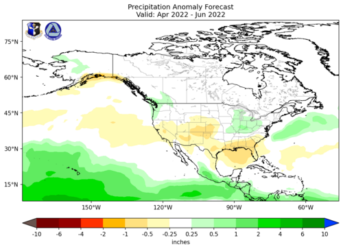
I look forward to the discussions this upcoming season. I am inclined to agree, Gas prices and everything else is gonna have some impact but I think I plan on chasing end of May into June, possibly Mid June trying to find the LP structure , but as I was looking at some of the products posted below that I normally look at. I got the impression that maybe, we might see something similar to last year where end of may into June was all about the Dakotas , WY, & MT? with a few decent days further south. Still way too early to tell of course. Either way, I am definitely looking forward to the chats, analysis and some pic sharing of peoples chases! . Good luck and be safe this year. Maybe the Hoard wont be as large with gas so high lol.

prediction_precip_northcom_sa_3.pngprediction_precip_northcom_sa_2.pngprediction_temp_northcom_sa_3.pngprediction_temp_northcom_sa_1.png
 
Hey everybody, I figured id get the ball rolling with the 2022 State of the Chase Season thread given we are now at 2 weeks since the new year. Hoping to see a repeat of last years awesome discussion with a few seasonal forecasts thrown in! I wanted to touch on some verification for my seasonal forecast last year. Here is my post from March 1st last year.


Well, happy spring everyone! It being the start of traditional chase season I feel confident enough to lock in a forecast.

Forecast 20201 Tornado Season (MAMJ) :

Counts: Average (754 tornadoes across the CONUS during spring, 1250 plus or minus 50 for the year)
I feel fairly confident on average numbers for the chase season and year. With a moderate La Nina, but complicating factors such as drought, I think we see pretty normal activity. This activity should pick up fairly quickly here over the next two weeks with the first hints of the spring pattern shaping up. Some killers for this would be an early northward retreat of the jet (Aka Death Ridge) cutting into numbers early. This is a distinct possibility given the ongoing drought. A second, perhaps better for us failure mode would be a weak resurgent la nina. This could throw out some higher tornado numbers, though I think this is less likely. Its about 50/50 which side of the coin we end up on, which means I'm going to hedge to average.

Outbreak Days (10+ Tornadoes within 6 hours): Above Average
Its an emerging trend, fewer tornado days, but more tornadoes per day. Im sticking with that. You can define outbreaks in many ways so I'll have to run some stats to verify, but I think we see a more active outbreak pattern going into April and a few very big count days. The forecast is also calling for an above-normal hurricane year. I think we see another active TC tornado year this summer and fall.

Number of EF2+ tornadoes: Well Above Average (Greater than 1 STD above the normal mean)
Im taking a bit of a risk on this one but, with the southeast and eastern half (more populated) of tornado Alley looking more favorable, I'm leaning towards a much higher count of sig tors for the simple fact I expect more of them to hit things. The same trend will probably hold for fatalities.

Chasabillity Score: Average 6/10
My completely scientific and no non-sense chasing index, just kidding it's entirely arbitrary. Not a great year, not a bad year, somewhere right in the middle with a bit more chasing potential. We probably won't be chasing west of I-35 as much as we would like putting a dent into the chaseabillity of some systems, but the average counts combined with a few bigger days will get peoples chasing counts up. Midwestern gang and the southeast should have a decent year. Southern and central plains also won't have much to complain about. Perhaps not the best for the front range and Texas Panhandle guys and gals but a few days spark off. A banner year for a few, but sufficient for most.


We will see where we go from here. Good luck to everyone, stay safe and happy hunting!


A couple of points. Overall my yearly number prediction was pretty darn close. I predicted just below average on the annual inflation adjusted count and was darn close with the year end reports falling just 30 shy of my bottom end (1250 plus or minus 50). My big miss was the fact that April was very quiet and October and December ended up saving the average!
View attachment 22463
As for my spring count estimate (754), I fell a bit short with only 703 tornadoes being recorded between March and June. As mentioned, April was unusually slow this year with only 73 reported tornadoes. But again, not terrible with how things ended up.

View attachment 22464
Moving on to the outbreak Days, I'm still working on some verification metrics for this. It appears as though there were much fewer outbreak days but the few outbreaks we did have were sizeable. This is a known trend with tornadoes as of late and something I need to look at further. For now I'm going to assign a fail to this part of the forecast as I suggested things would be more active than they appeared to be. And several key outbreaks occurred well into the cool season outside of the time range I was really shooting for. I did make explicitly mention for the threat for several outbreaks associated with land falling TCs, this appears to have gone well with several big days happening across the Mid Atlantic.

Now to EF2+ tornadoes, Again, still working on some verification metrics for the counts of EF2+ but subjective interpretation says I did okay in this regard. The big outbreak days we did have produced quite a few sig tors. We also had the most fatalities since 2011 so that fits with the well above average forecast. I was expecting more during the spring when the December events ended up contributing to most of those. I need to work on some plots since the sig tor data isn't readily available.

Totally objective chaseability score wise I'm going to assign a hit to this for now. It seems like people who were able to get out did have an okay year. I do suspect however the objective metrics will be much lower across the plains when that data is run by Brett. The lack-luster April and only average May/June likely wont compensate for each other and I'm betting its a below average year. Subjectively there were some good tornado days as always. I did pretty poorly but most of that was beyond my control having to limit my chases. I did break my personal 4 year tornado drought in October in Southwest Oklahoma which feels good.

Now looking ahead, I'm seeing a fair amount of the same signals that we saw last year hinting that this year could again be a mixed bag. The big difference looks to be in the way ENSO is expected to evolve through the spring. While we did expect a weakening of la Nina last year, El Niño chances were much lower than this year with CPC calling for 60% chance of EL Nino development by summer/Fall this year. As I mentioned last year, positive TNI events (typical of Nina-Nino transitions) can result in active stretches particularly in the Midwest and southeastern US. Another big factor is the ongoing drought across the western US. How this impacts things is yet to be seen. I suspect the overall impact will be negative on the Plains at least through the early parts of the season. My current gut forecast is calling for an active year east of I-35 but the potential for lower counts in the Plains through spring again. I think things will heat up early season (Mar/April) again as la Nina continues to decay. (Western Gulf Coast southeast and Midwest) April in particular looks interesting. Positive TNI events can result in a significant uptick in probabilities for large outbreaks near and even west of I-35 in April. The GOM is quite warm and should remain so through the spring which is a positive sign for higher than average moisture flux and buoyancy. But, the signal for anything specific really drops off into May. If I had to guess, id expect a below average May this year with concerns about the ongoing drought the potential for El Niño to rapidly develop shifting ridging over the Plains. All in all though kind of a crapshoot this year. By March 1st we should have a much better idea of how things are shaping up. If you're planning a chase cation, I wouldn't stray from the traditional times as statistically its still your best bet. But, if you have the potential to chase earlier in the year pay attention in March and April in particular.

View attachment 22465
Curious on everyone else's thoughts?
I was really curious whether or not you have done or shared any verification analysis based on your past predictions say by looking at the last years issued Tornado Warning concentrations by quarter and comparing that to your predictions ? I think that would be neat to see if you have done any of that.
 
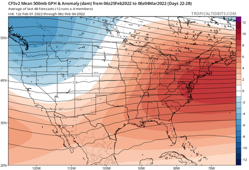
Second half of Feb starting to look more and more like a return to east coast troughing. The gulf is probably going to get wiped a few more times before things get cranking.

It's the March/April/May pattern on the CFS going forward that gives pause. Anyone much west of the Mississippi should be really concerned about another drought year. We all know these long range forecasts tend towards a crap shoot but it still is worth a look.

If I had to pick a hotspot for early to mid-spring this year it would be the mid-south/ohio valley. Per the trends already observed this year and the CFS.

The southern to central plains aren't looking great but we all know how quickly that can change. Might be a good old-fashioned midwest la Nina multi-outbreak year, time will tell.
 

Attachments

  • 814temp.new.gif
    814temp.new.gif
    395.4 KB · Views: 0
Last edited:
Second half of Feb starting to look more and more like a return to east coast troughing. The gulf is probably going to get wiped a few more times before things get cranking.

It's the March/April/May pattern on the CFS going forward that gives pause. Anyone much west of the Mississippi should be really concerned about another drought year. We all know these long range forecasts tend towards a crap shoot but it still is worth a look.

If I had to pick a hotspot for early to mid-spring this year it would be the mid-south/ohio valley. Per the trends already observed this year and the CFS.

The southern to central plains aren't looking great but we all know how quickly that can change. Might be a good old-fashioned midwest la Nina multi-outbreak year, time will tell.

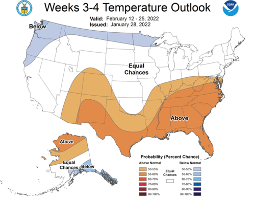
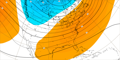
Interestingly enough CPC is a bit at odds with their own forecast from a few days ago rocking a fairly big shift beyond week 2. This could be due to differences in the deterministic and smoothed weekly guidance. CFS/ECMWF weeklies are all in pretty good agreement that the last week or two of February into early March will feature above-average heights out east and greater precip potential farther west (implying western us troughing and higher heights east). That seems to check more with what CPC has for weeks 3 and 4 (They should update today will see if they change). I think any eastern US troughing is likely to be short-lived in weeks 2 and 3 as there are hints of a return to an active MJO regime and -PNA. Agree the gulf will be swept a few more times in the coming weeks that's climo. But I'm still fairly bullish on late Feb and early March for more active conditions.
1643997079706.png
1643997174749.png
ECMWF weekly 500 zonal height anom Feb21-Feb28
1643997273016.png

I agree with what you said about the Ohio Valley. Ive been watching that area too for much more active conditions this spring. The analogs are all pretty favorable for up there.
 
I was really curious whether or not you have done or shared any verification analysis based on your past predictions say by looking at the last years issued Tornado Warning concentrations by quarter and comparing that to your predictions ? I think that would be neat to see if you have done any of that.
Good question Jason! I haven't done anything with tornado warnings. I tend to shy away from using warnings as verification because technically warnings are a form of short-term forecast and using a forecast to verify a forecast can get tricky, but it's an interesting idea. I've thought about using watch or outlook anomalies in much the same way you suggested but reports still seem to be the most objective way to do things.
 
Hey everyone,

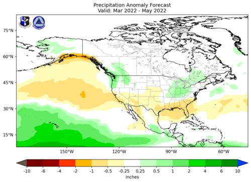
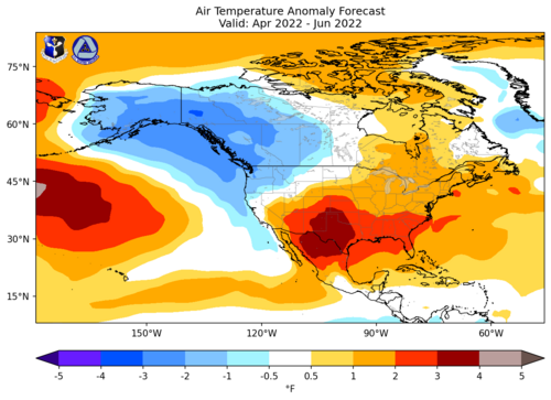
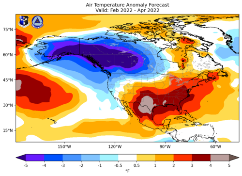
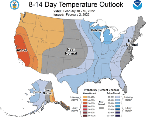
I look forward to the discussions this upcoming season. I am inclined to agree, Gas prices and everything else is gonna have some impact but I think I plan on chasing end of May into June, possibly Mid June trying to find the LP structure , but as I was looking at some of the products posted below that I normally look at. I got the impression that maybe, we might see something similar to last year where end of may into June was all about the Dakotas , WY, & MT? with a few decent days further south. Still way too early to tell of course. Either way, I am definitely looking forward to the chats, analysis and some pic sharing of peoples chases! . Good luck and be safe this year. Maybe the Hoard wont be as large with gas so high lol.

View attachment 22487View attachment 22486View attachment 22489View attachment 22488
Jason, these graphics are pretty cool is the AF climate group producing these? I can see the similarities with CPC but do you know what they are using to make these?
 
Interestingly enough CPC is a bit at odds with their own forecast from a few days ago rocking a fairly big shift beyond week 2. This could be due to differences in the deterministic and smoothed weekly guidance. CFS/ECMWF weeklies are all in pretty good agreement that the last week or two of February into early March will feature above-average heights out east and greater precip potential farther west (implying western us troughing and higher heights east). That seems to check more with what CPC has for weeks 3 and 4 (They should update today will see if they change). I think any eastern US troughing is likely to be short-lived in weeks 2 and 3 as there are hints of a return to an active MJO regime and -PNA. Agree the gulf will be swept a few more times in the coming weeks that's climo. But I'm still fairly bullish on late Feb and early March for more active conditions.

I mis-spoke. I should have said more like mid February. Agreed, as we approach March the modeling is more favorable for some southeast warmth and the gulf beginning to recharge.

The long-range pattern honestly looks a little scary for the OV and Dixie Alley and hasn't flip-flopped one bit for months now. It's a strong la Nina type signal and with this being a 2nd year Nina it's hard to ignore.

If it stays a La Nina, wouldn't it technically be a 3rd? Because 2020 was as well, correct?
 
If it stays a La Nina, wouldn't it technically be a 3rd? Because 2020 was as well, correct?
Splitting hairs maybe, but we have had la Nina conditions for the most part since fall of 2020, so this is our second spring season with a la Nina.

Either way, the analogs to multi-year cold episodes are hard to ignore. But last spring was mostly a dud, and I know you can't base severe weather predictions solely off Enso.

Definitely a pattern adjustment showing up on long range guidance as our original poster has shown. March looks very active east of the Mississippi.
 

Attachments

  • download (2).png
    download (2).png
    258.2 KB · Views: 0
  • download (3).png
    download (3).png
    169 KB · Views: 0
I had wondered about the long-range pattern as well. and going back to last year, I remembered we were discussing things like split Jet patterns, MJO/NAO/PNA alignment, the Polar Jet Retrograde happening too fast to really allow for a solid spring out-breaks outside of transient patterns, so it will be interesting to see what we see compared to last year. I remember talking about things like the state of the Artic Ice (not terrible based on the NSIDC analysis currently - despite being still below normal it seems similar to 2009 for the moment) will that come into play this spring in anyway?. The state of current drought maps. I got to remembering EML discussions we had for a bit last year, and with the current pattern shifts again and moistens the plains in the next couple months. I remember last year there was talk about the EML from NM/Arizona north. The funny thing was later in the season last year, they ended up getting some good chase days!. so it should be neat to see what signals present as we move into AMJ.
 

Attachments

  • sea ice.jpg
    sea ice.jpg
    163.6 KB · Views: 0
Good question Jason! I haven't done anything with tornado warnings. I tend to shy away from using warnings as verification because technically warnings are a form of short-term forecast and using a forecast to verify a forecast can get tricky, but it's an interesting idea. I've thought about using watch or outlook anomalies in much the same way you suggested but reports still seem to be the most objective way to do things.

ok that's a good point about the warnings, I just figured polygons would be easier to use, but then you're right depending on the accuracy level you're trying to achieve. warning polygons could be at least a refined start, followed by maybe some actual track analysis maps and maybe even severe Hail GEOJSON' mapping. whatever you choose to use that's effective and maybe helps you refine your forecasts
 
Jason, these graphics are pretty cool is the AF climate group producing these? I can see the similarities with CPC but do you know what they are using to make these?

Adlyons, the 14th Weather Squadron, formerly known as AFCCC (Air Force Combat Climatology Center) reproduces and develops a weekly Operational climate report. it does grab graphics from the CPC and other sources connected to the NCDC / WMO, and it also does some of its own analysis/forecasts based off of the CFSv2/SUB-X and a few other models and data sources it has to create its product, especially for military application. The reports do specify the data sources I but I am not staring at them currently so I can't answer it with certainty right this moment.
 
Wednesday and Thursday confidence is increasing for a two-day sequence from the Southern Plains through the Ozarks into the Mid South. Wednesday everything is just-in-time during the day Southern Plains, but the Ozarks may go at night - suboptimal.

Thursday appears the parameters will be in place Mid South to North Alabama. Much will depend on morning rain holding off or lifting north by Noon. That's the difference between Mississippi meh and a wider regional event.
 
Well, as we get ready to flip the calendar to the first month of meteorological spring, right on schedule there's something to discuss. Let's just say if the last two runs of the GFS are anywhere close to verifying synoptically and the model is underdoing the instability across IA/IL beneath upper 50s dewpoints, next Saturday could be a chase day for me. Still a long ways out obviously but the general signal is there on the Euro and its ensemble as well for some severe weather somewhere in the central/eastern CONUS starting this coming weekend. That's about all that can be said with confidence at this point.
 
A few days late but ill throw my final thoughts for a seasonal forecast for 2022 into the fire to be burned up by mother nature. Sadly, this has the hallmarks of another meh year. I've long be resistant to the idea of a weak decay La Nina or possible third year Nina in favor of a shift to EL Nino, but I'm finally backing off that. There has been a substantial drop up inn sub surface warming over the last few weeks which has stalled any Niño condition development. The most likely scenario for spring appears to be a gradual decay of La Nina into ENSO neutral. The MJO while more active as of late has shown minimal activity thus far which is also another negative. Add that to the ongoing drought in the West and you end up with analogs like 2009, 2012 and 2018. You see where I'm going with this... These weren't the worst years but they were easily bottom half of the distribution. I think we are in for more of the same. Somethings that could improve our odds, a stronger MJO later in the spring, and continued warmth in the GOM.

A grand summary, I expect not a great year for chasing. A few notable outbreaks possible through March and April. I'd pay special attention to the Midwest and Mid South as these areas have historically done better in these years. The southern Plains will likely be limited in chase opportunities so take chances. The southern High plains look to be very quiet sorry TX Panhandlers and southern Colorado. Big question mark in the central and northern High Plains. Its a mixed bag in these years especially late, but predictability of tornadoes in the summer is low. Below are the numbers.


Forecast 2022 Tornado Season (MAMJ) :

Counts: Below Average (600 tornadoes across the CONUS during spring, 1050 plus or minus 100for the year)


Outbreak Days (10+ Tornadoes within 6 hours): Average


Number of EF2+ tornadoes: Below Average (Greater than 1 STD above the normal mean)

Enjoy my very scientific graphic lol. Good luck this year everyone!2022CONUS.png

Chasabillity Score: Average 5/10
 
I'd be satisfied with more regional chase opportunities especially with gas prices the way they are...for a long time I was drawn to the idea of classic central-southern Plains May chasing but it hasn't been kind to me so if it goes out the window for yet another year, so be it.

Just so long as more of the setups are in the IA/IL portion of your zone and not MO (there's a reason chasers call it "Miss'ry," lol).
 
Ensembles continue to suggest an active pattern for April with multiple opportunities for severe from the plains to the midwest and southeast looking increasingly likely. Right now, the period around 4/11-4/13 looks interesting. Beyond that it appears we may continue to see western CONUS troughing to close out the month. At this point, I think it's safe to say that average tornado activity for April is probable, with the odds leaning to above average. Hopefully this year doesn't end up like a 2012 where the atmosphere decides to shut things down early. Would love to see a season extended well into June, but the ongoing drought doesn't bode well for those hopes.
 
Back
Top