State of the Chase Season: 2015 Edition

If you recall, it happened last May. Although it was an overall low end system, it did kick off a few days of severe weather and a few tornadoes.
 
scratch what I said about next weekend apparently.
Maybe I spoke too soon?
GFS_3_2015041518_F240_WSPD_500_MB.png
 
Yeah it's *almost* pointless to look beyond 8 days. It can just give you a general sense of the activity, but even then. I love to use the DeltaT function on twisterdata and see if it's just noise or part of a trend or if there's real certainty. That said, It's totally reasonable that there will be some sort of uptick in activity in the april 23-27 timeframe. Fronts clear out, moisture advects north and west, Jet finds its way through the plains.
 
Watching dProg/dt for the FIM lately, it seems like the trend/predictability window is pretty much wide open before 100 hours and closed tight after 200 hours, with a non-linear ramp down between. At 240 hours, there's no guarantee whatsoever that such a pattern will be present.

In my experience, models generally don't "trend" over a very long period of time. Many people refer to the GFS's tendency to slow things down. However, I tend to find that it dramatically slows things down over the course of just a day or two (maybe 4-6 model cycles), beyond which little to no tendency is maintained. Sometimes the shift occurs past hour 100, sometimes it's more like fhr48-84.
 
Apologies if this has been posted before (it may well have been in another thread in the past and hence why I have the link!) but this chart is pretty neat:

http://wxvu.net/spc/cfs_scp/

The explanations as to what it shows are on the site.

Looking at the next 7-15 days the ECMWF ensemble package is suggestive of a western trough evolving later next week and beyond - whilst this is very far out it's been on a number of runs.
 
The eastern High Plains have received quite a bit of rainfall the past week. The Black Kettle/Cheyenne area picked up over 7 inches of rain the previous 7 days with the eastern TX PH probably receiving just as much. Feeling pretty confident we may have a good season further west for the first time in awhile considering I haven't seen multiple days with supercells out that way in quite awhile.
 
Looks like the GFS is progressively getting more insistent on some active weather coming later this month. The 00Z run has multiple waves moving through from Arpil 23-26 time frame, then shows an interesting trough coming in over the Pacific Northwest and moving it out over the plains 28-30th. If only it were that easy right? :confused:
 
The eastern High Plains have received quite a bit of rainfall the past week. The Black Kettle/Cheyenne area picked up over 7 inches of rain the previous 7 days with the eastern TX PH probably receiving just as much. Feeling pretty confident we may have a good season further west for the first time in awhile considering I haven't seen multiple days with supercells out that way in quite awhile.

A lot of the climate models and analogues for the current pattern show a wetter than average spring for a lot of the Plains, especially the High Plains, and the Front Range. Indeed, flooding could become an issue in places.

To me, this suggests a higher than normal influx of Gulf moisture into the western parts of the Plains, not often favourable for Great Plains events (dryline to far west, etc etc). Of course, sub-seasonal influences will, of course, mean that eastwards-moving troughs and upper lows will occur, but perhaps a little less regularly than might be expected.

That being said, some nice High Plains action with supercells moving off the various topographical features out west (rather like last May) can make for excellent chasing!
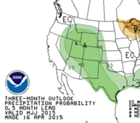

Some areas are expected to get drought improvement this year. It would be nice.
upload_2015-4-18_8-37-16.png
 
It's been nice not seeing the slew of fires that are typical in OK. We'll take all the rain we can get. This time last year, I was dodging wildfires jumping the highway during my daily commute.

I'm going to laugh if something does happen this next weekend (25-26 Apr) because something almost always happens the weekend closest to my bday, when my family expects me there so they can celebrate.
 
Almost time to start forecast threads for dates next week. I'll leave that to others.

Things I like about forecasts for next week:
-A very strong sub-tropical jet stream pretty much nationwide. Almost seems unseasonable. On any day after about next Tuesday, anvil relative flow is going to be nuts. We could be seeing a ton of LP type storms. At the very least, if supercells form on any day, they shouldn't be HP.
-Pretty decent moisture quality for the time of year. This current system and the big Hudson Lake trough don't really clear out the Gulf, and there is sufficient moisture return to give pretty deep moisture as far north as I-40 or so
-With good rains over the southern Plains this past week, that will keep soil moisture up and temperatures down, so there won't be terrible capping, although there will be some capping
-The CFS is picking up on a signal suggesting many days where the atmosphere will be suitable for supercells

Things I don't like about next week:
-The GFS and FIM aren't exactly showing any textbook or obvious outbreak type setups, although they do show suggestible patterns. As of right now it looks like Wednesday and Friday may be the most interesting days.
 
Adding on to Jeff's post above, in addition to this upcoming week's potential, I'm seeing a pretty good consensus in the ensemble guidance right now (especially considering the range) towards a negative mid/upper level height anomaly being established from the eastern Aleutians and Gulf of Alaska southeastward into the western CONUS in the late days of April.

As the northeastern upper low finally shifts to the east, we have higher latitude ridging over western Canada, which may serve to lock the aforementioned troughing/negative height anomaly in place as jet streaks round the base of the troughing and possibly eject into the central US (potentially phasing with the impressive sub-tropical jet as well). This type of regime would definitely lead to the idea of an active start to May, on top of the recent rainfall leading to increased moisture content over the Southern Plains/elsewhere as Jeff mentioned and the torching Gulf of Mexico, which currently has a nearly +2˚C SSTA. Again, this is fairly long range, so there are obviously a lot of things that could throw a wrench into this scenario, but for now, as far as a general synoptic pattern goes, I'm liking what I'm seeing. We're also starting to get to that point climatologically where we don't necessarily need moisture trajectories from deep in the Caribbean for a juicy warm sector, and obviously the very warm Gulf will help there too.
 
There is especially a lot to like about Wednesday. Jeff touched on the anvil level winds, which seem to be stronger than any of the systems we've seen so far. CAPE values are pretty nice as is moisture. Hopefully this is the week the season actually makes a turn around at least for the plains.
 
Back
Top