Upcoming 2016 Storm Chasing Season

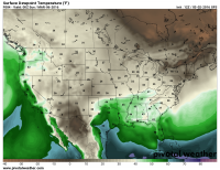
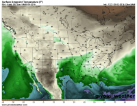
Interesting to note the differences between the NAM and GFS on the extent of moisture return come Saturday evening. Seems the GFS is getting hung up on a weak frontal zone that's cutting off moisture return north whereas the NAM resolved it differently and doesn't have the frontal zone even surviving to the same time period.

cd2a924ef7fac3dd85162b629bdfc9ca.png

8a4fb99ce9efaf80e866198b5e0db16c.png
 
Hope everyone's dusted their equipment off and ready to burn a day or 2. Looks like March is going to breath in life to the chase season. Can't wait to chase the plains again!
 
Interesting to note the differences between the NAM and GFS on the extent of moisture return come Saturday evening. Seems the GFS is getting hung up on a weak frontal zone that's cutting off moisture return north whereas the NAM resolved it differently and doesn't have the frontal zone even surviving to the same time period.

]

I was just noticing the same thing this morning on the 06Z runs of the NAM and GFS @84hrs. significantly broader area of southerly return flow and or much weaker offshore flow along gulf coast. This excites me. If moisture return improves monday may have alot more things going in its favor, most notably more cape which is currently progged to be very skinny both spatially and on the forecast soundings.

I see there's no forecast thread for monday yet plus this issue generally refers to multiple days so figured still fine to post in here.
 
12Z GFS finally getting onboard with better overall moisture quality. Seems like the moist axis is going to be positioned perfectly on that sharpening dryline if this maintain on Monday.

Sent from my XT1080 using Stormtrack mobile app
 
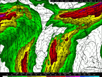
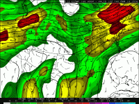
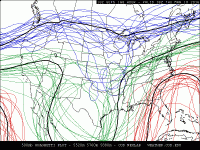
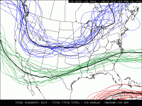
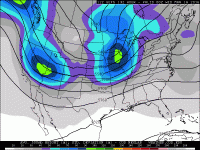
Maybe someone with more knowledge than me can help me here. Does anyone actually think this huge digging trough all the way into central mexico is actually gonna take place late next week? I've been casually watching weather models since about 2005 and this seams highly irregular and unlikely that it would actually take place. I have often seen these signals for a run or 2 at this range but rarely this consistently, and these GFS digging bombs typically don't come to fruition. However, the GFS and the ECM have been very consistent with it in every run over the last 3 or 4 days. The last graphic is the 500mb spaghetti plot from the GEFS and it does show a large amount of uncertainty, but (and again maybe someone can help me here) is that amount of uncertainty really any different than one would normally see at that range?

Whats your guys take on a probabilistic estimation on how likely this is I mean we are getting well under 180 hrs now.

EDIT: It does look like there is deep trough out towards bermuda right off the east end of the image, perhaps blocking typical eastward progression

gfsUS_500_spd_150.gif

ecmwfUS_500_spd_168.gif

gefsUS_500_hghtens_168.gif
 

Attachments

  • ecmwfUS_500_spd_168.gif
    ecmwfUS_500_spd_168.gif
    52.9 KB · Views: 91
Last edited:
As I mentioned in a previous post, with this level of consistency, I would tend to believe this trough may actually manifest.
 
Like you said...there's enough run-to-run and model-to-model consistency to take note. Even the GEFS ensemble mean has the cutoff low in Mexico. A similar cutoff low formed around December 27th of last year.
 
Which that system also produced record tornadoes for the month of Decemeber for N Texas. No two systems are the same of course but, there is some striking similiarities and some favorable conditions. Even though there is some consitancey in the model runs which is rather encouraging, it also makes you a little suspicious at the same time.
 
I gotta admit, the 84 hr Nam accumulated precip. doesn't look to shabby for the EML source region AND helping green up over TX and OK. (always keeping May in mind)
 
Obligatory comment about how this is still a week away aside, this next trough http://maps1.pivotalweather.com/models/gfshires/20160309/06Z/f162/500mbconus.png has been quite consistent for multiple runs now. It could definitely be better in many aspects, but it will be fun to keep an eye on over the coming days. Even AFDMPX got quite excited about it this morning...

"JUST SEEING THE WHITES OF THE EYES OF A MORE DAUNTING SYSTEM
PROGGED TO ARRIVE TUESDAY NIGHT AND WEDNESDAY...IN THE FORM OF A
SUB-990MB SURFACE LOW THAT LIFTS A WARM FRONT ACROSS THE AREA
INTO WEDNESDAY. WILL NEED TO MONITOR THIS CLOSELY...GIVEN CURRENT
PROGGED SHEAR/INSTABILITY PARAMETERS ON BOTH GFS AND ECMWF
SOLUTIONS...WHILE DESPITE THE TEMPORAL AND SPATIAL
DIFFERENCES THEY EXHIBIT...WOULD BE CONSISTENT WITH SEVERE
WEATHER POTENTIAL /INCLUDING TORNADOES/ FOR MUCH OF THE FORECAST
AREA."
 
Last edited:
Continuing with the system for the middle part of next week, if the GFS is correct as of right now, there is a lot to not like... The timing and position of features leaves no southern plains play. Everything would be east of I35. Also, that everything I am referring to may end up being nothing at all, since warm mid level temperatures are forecast to brutally cap basically the entire warm sector. With that said, I think the GFS does tend a bit fast at this range, so a lot can still change.
 
Once again, I highly caution any use of a single deterministic model run past about 120-150 hours. It is highly likely, if not a virtual certainty that the forecast for a system at that range will change, if not dramatically, then at least in the details, in later forecasts.

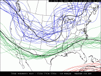
Use ensemble products. I cannot stress how useful and valuable probabilistic forecasts are for synoptic scale features at that range. Getting hung up over one run is just going to stress you out. For example, 12Z GEFS 500 mb spaghetti plot:
gefsUS_500_hghtens_156.gif

Incredible variability on the shape and location of any trough. I see trough axes as far west as Nevada (neutral to slight positive tilt) and as far east as Illinois (slight negative tilt), with really all the parameter space in between filled pretty evenly.
Furthermore, a dProg/dt from the GFS control member has changed dramatically over just the past 24 hours.

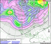
Let's look at some other ensemble products. First, the NAEFS (from EC's website):
2016030900_168.gif

Big ol' spread bullseye in the SW US with increased spread all along the ensemble mean mid level jet stream -> very large differences between some ensemble members in terms of 500 mb heights in that area -> large uncertainty in trough placement.

How's about the ECMWF EPS?
ECMWF_EPS_mslp_f168.png
ECMWF_EPS_500mb_f168.png

Yes, the age of these forecasts differ (ECMWF and NAEFS products come out much later than GEFS products), but the 00Z GEFS looks even more funky during that time frame.
 
Mode will be an issue too. At least for now that front is moving just shy of warp speed right into that environment. We'd really need to have something out in that stoutly capped warm sector, unlikely, or we are looking at a nice wind event only. LOTS of time left and major changes guaranteed
 
As a follow-up to my post yesterday, today's 12Z GEFS now shows a bimodal distribution of 500 mb heights with at least 7 or 8 (of 20) members progging a western US trough while at least 5 or 6 members have a central US trough:

gefsUS_500_hghtens_132.gif

This disagreement shows up nicely in the ensemble spread plot:
gefsUS_500_sdev_132.gif

Based on other operational ensembles that prefer the eastern solution, I would hedge that way as well. The 00Z FIM actually suggests another one-two punch much like this week with a lead shortwave followed by a higher amplitude trough a day or two later. In my experience, unless the lead wave is pretty weak, it tends to wipe out the environment ahead of the bigger wave behind, thus screwing both setups (since the lead wave can be pretty underwhelming). If the FIM verifies, that's exactly what will happen. I'm not surprised to see that in early-mid March, however. It's still winter in the Northern Hemisphere and there's still cold air being produced in Canada. Come April, and especially May, the lead wave screwing up the environment should be less of a problem.
 
Focusing on the northern end of this system.....00z NAM and GFS runs seem to be in general agreement at the 84 hour (12z Tues 3/115). NAM brings the system in a little further south than GFS, while the most recent run of the Euro has this system much further north. What we seem to know at this point is that there will be a rather deep low moving across IA or MN during the early part of the day Tuesday. Ahead there will be mid-upper 50's dews and hefty sheer.

GFS, Chicago 18z sounding for Tuesday shows a low cape, high sheer environment which will likely be wasted on a blazing fast cold front. I'm still thinking this will be a wind event with perhaps embeeded supercells. If the front slows down a bit I'll change my tune. It's really fun to watch these early systems and play what-if games. We shall know more tomorrow.

http://www.pivotalweather.com/model...fh=90&r=conus&lat=41.8295&lon=-88.1590&metar=
 
Back
Top