-
While Stormtrack has discontinued its hosting of SpotterNetwork support on the forums, keep in mind that support for SpotterNetwork issues is available by emailing [email protected].
You are using an out of date browser. It may not display this or other websites correctly.
You should upgrade or use an alternative browser.
You should upgrade or use an alternative browser.
State of the Chase Season 2022
- Thread starter adlyons
- Start date
Ethan Schisler
EF5
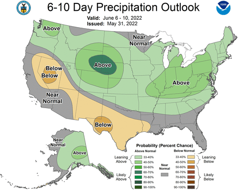
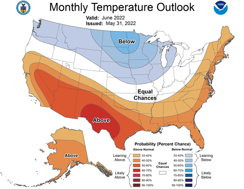
Least we are in the above normal precipitation, not liking the below normal temperatures again. On the positive though, my local area (KDVN), on my Facebook, the memories from 1 year ago popped up. It showed that at this point we had only seen 1 TOR warning and 2 SVR warnings the entire CWA and this year we are far ahead of that. Last year turned out very good locally, so there is some hope there. I had planned to take a chase trip last week, but basically just ended up chasing Monday's bust in Northeast Kansas (I didn't like Minnesota's set up at all) and then come home and snagged a multi-vortex tornado a few miles from my apartment late at night.
Not the worst year, but also far far from the best. And now with gas at 5.09-5.29 locally, it will most likely be a local chase mode for the rest of this season.
Not the worst year, but also far far from the best. And now with gas at 5.09-5.29 locally, it will most likely be a local chase mode for the rest of this season.
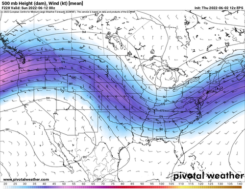
My chase vacation starts in the middle of next week and this is what I was hoping wouldn’t happen. Don’t get me wrong, it could be worse, we could have a death ridge with no signs of any storms anywhere on the plains. At least we’re likely to get some high-based stuff coming off the higher terrain, which can be pretty fun. But I’m a little bummed that I probably won’t be chasing any days with good tornado chances.Nothing but northwest flow events, high plains magic for June. Oh how the tables turn.
View attachment 22854
View attachment 22855
JamesCaruso
Staff member
My chase vacation is coming to an end. I have to be back at work on Monday. I normally don’t book my flight home until the end of the trip so that I can be flexible. Obviously to be at work on Monday, I don’t need to fly home until Sunday, but I do like to have a “buffer day” at home between chase vacation and back-to-work… So I am biased toward flying home Saturday and not chasing that day… I didn’t even do much analysis for Saturday, but based on SPC Day 3 and a very quick look at moisture and 500mb, I don’t think I would be missing much…
Considered flying home on Friday - a full weekend “buffer” is even better - but figured I would take a chance on some SE Colorado upslope tomorrow and then fly out of DEN on Saturday… Not too optimistic about tomorrow, but my son is very much enjoying his first trip out here, and I didn’t have the heart to tell him we are going home tomorrow, it seems too much an abrupt end to the trip, and didn’t necessarily fully take in that “this is our last chase until next year” moment while chasing yesterday’s storms near Jal NM and into Andrews County TX (although, maybe consciously thinking that actually prevents one from fully taking in the moment… but that’s a topic for another thread LOL).
In Lubbock this morning and will migrate north by this evening to some point TBD.
Andrew Butler
EF1
My chase vacation starts in the middle of next week and this is what I was hoping wouldn’t happen. Don’t get me wrong, it could be worse, we could have a death ridge with no signs of any storms anywhere on the plains. At least we’re likely to get some high-based stuff coming off the higher terrain, which can be pretty fun. But I’m a little bummed that I probably won’t be chasing any days with good tornado chances.
It's a whole heck of a lot better than insta death ridge that we have seen so much the past several years. Colorado hardly ever disappoints in this kind of pattern whether it be structure or even good tornado days. I really wish I could afford the gas this year. But it looks like it will be local chasing for this guy for the rest of the season. And by local, I mean LOCAL. Lol.
Warren Faidley
Supporter
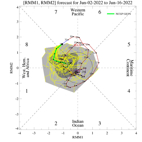
Looking at the ensemble forecast products and a few other things, it would appear the SW flow, SP season will come to an end early next week. Still some opportunities for NW flow events at some point, but not worth waiting it out given the low-preforming season so far. This on top of smoke and dust issues. Time to focus on the SW Monsoon / Haboob season in 3-4 weeks and the hurricane season which should be interesting given another year of weak westerly flow.
Yeah the high plains can often produce something decent on even MRGL days. I’ve chased some pretty storms with dews in the mid 40s before. Just gotta hope this NW flow pattern can yield something really good.It's a whole heck of a lot better than insta death ridge that we have seen so much the past several years. Colorado hardly ever disappoints in this kind of pattern whether it be structure or even good tornado days. I really wish I could afford the gas this year. But it looks like it will be local chasing for this guy for the rest of the season. And by local, I mean LOCAL. Lol.
Matt Hunt
EF3
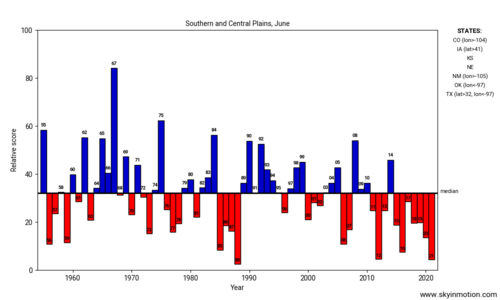
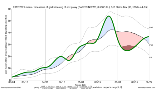
Safe to say that was a very underwhelming month of May. Debating taking a later chasecation next year in mid-June and hope for some Northern Plains action, but that hasn't really been happening in recent years, either. What is the deal? It seems like we haven't seen a truly active severe weather season in years! While there have been some good one-off events, they've mainly been localized events, not the outbreaks that I feel like used to happen several times per year.
Brett Roberts
EF5
Ethan Schisler
EF5
Ugh.....guess pool season starts early this year. That is if it ever decides to quit raining and stay hot here in IA/IL. Hoping somehow for a miracle in mid-late June or even July this year. Definitely not a year without spectacles to behold, but one that has been exceedingly difficult to forecast even up until 12-24 hours of the event.
Is it too soon to already just be done with it and ready for next year? lol.
Is it too soon to already just be done with it and ready for next year? lol.
Brett Nickeson
EF2
Andrew Butler
EF1
LOL. ^That's great.
Everyone was jumping out of windows and off bridges last few years because of death ridge. I mean at least the jet is still not, nor will be anywhere near Canada for the foreseeable future. This counts for something, right?
Right???
Everyone was jumping out of windows and off bridges last few years because of death ridge. I mean at least the jet is still not, nor will be anywhere near Canada for the foreseeable future. This counts for something, right?
Right???
Jesse Risley
Staff member
Since it's early June, it's important to keep in mind that you can still have over performing setups, especially across the Northern Plains, northwest flow events across the Midwest, and terrain-induced supercells east of the front range all the way up into Montana. It's important to monitor the location of embedded mid-level perturbations, the extent and placement of moisture, and associated lifting mechanisms at the surface but I've had some of my best chases within otherwise mediocre mid and upper-level patters.
So while we may not be getting massive troughs that yield synoptically evident severe weather outbreaks, there may still be plenty of opportunities in June for those able to capitalize on severe weather mechanisms coalescing across climatiologically favorable areas. I suspect we still have several days in June where Colorado and perhaps Southern Wyoming will reward, and hardly a year goes by without a spectacular supercell or three across Eastern Montana into the Western Dakotas. Canada is also back open for business this year for those with passports.
June typically rewards but it sometimes takes patience and picking the right setups.
Randy Jennings
Supporter
- Joined
- May 18, 2013
- Messages
- 880
Andy Wehrle
EF5
The above pretty much confirms my perception of this past month...fairly active for storms in general, but frustratingly slow for tornadoes (especially classic supercellular, photogenic ones although those will always be a relatively small subset). Don't regret saving the gas money and sitting out this past Monday and Tuesday when what had looked like a potentially decent or even spectacular (if Monday had actually lived up to the early comparisons to 6/17/2010) 2-day regional setup went up in smoke (apart from the nocturnal tornado in IL, needed that to happen around 20-22Z Tuesday afternoon as the initial HRRR runs to come in range had depicted).
As an aside, anyone else not getting the little bell alerts for watched threads anymore? I only saw the posts after Monday in here because I went and clicked into the subforum.
As an aside, anyone else not getting the little bell alerts for watched threads anymore? I only saw the posts after Monday in here because I went and clicked into the subforum.
Similar threads
- Replies
- 79
- Views
- 10K
- Replies
- 8
- Views
- 2K
- Replies
- 59
- Views
- 10K

