Yep. Pretty much all medium range models aligning on a lot to like about this setup. I'm seeing no S-shape/VB in the forecast wind profiles, and it looks likely that there will be 70s dews ahead of the dryline throughout most of OK. The Canadian model was the one outlier so far keeping the 70-F isodrosotherm south of I40. I am seeing the signature of something that is becoming increasingly common in my experience regarding a northbound moisture surge that occurs late in the afternoon/early evening immediately against the dryline that fills in the warm sector that is otherwise a little "dry" east of the dryline earlier in the day.
Here's a depiction of what I mean:

Note that moisture drops in SW OK from 18-21Z but then resurges by 00Z. I've seen this happen before, both in the presence of and without the presence of existing convection. It's almost like a localized dry push above the PBL moves over the DL during the day, and the vertical mixing causes a temporary dropout in surface moisture quality, only for it to recover once the dry push moves on past. I'm not seeing as strong an indication in the GFS as in the ECMWF (depicted above), but it leads me to believe such a potential X factor could be in play.
How does this impact events? Not sure - it probably goes both ways. It could cause storms not to fire along the dryline in that portion of reduced moisture if capping is strong enough (the GFS shows a warm nose over the PBL this day). But it could also reduce storm competition and favor better spaced and discrete convection. There's probably also other impacts I'm not currently thinking of.
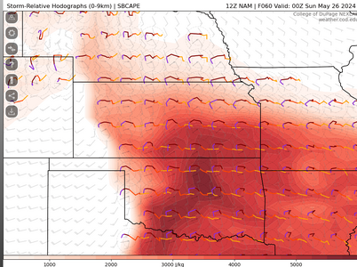
Anyway, we have two medium range CAM ensembles being run by NCAR until the end of the month, and at least from a terminal product point of view, they have somewhat differing views of this event:
C-SHiELD (FV3-based):

This one tends to omit most of OK from the fun and instead gives KS/MO a better show.
The MPAS-based ensemble is somewhat more favorable for the southern Plains, but there's still a lot of spatial spread:

Althouhh when you combine the ensemble information together, neither ensemble seems to think particularly highly of the setup, especially OK:


But given the forecast range, this may not be all that unexpected. Things will come into better focus over the next day or two.
CSU's ML outlook product appears to show a small moderate at this point:

We shall see. It didn't do half bad at the day 5 range with yesterday's event.