2024-05-26 EVENT: AR/MO/IL/TN/IN/KY

Patrick K

EF0
Joined
May 2, 2019
Messages
34
Location
Southeast USA
The negatively-tilted trough shifts east on Sunday from the southern plains toward the lower Ohio valley. Upper 60s to lower 70s dewpoints will be present across this region early Sunday, with storms expected to be ongoing across MO while a developing surface low pivots northeast into the northern MO / southern IA region by 18Z. The GFS especially likes clearing skies and recovering airmass in the wake of these early Sunday storms. Dewpoints are expected to rise into the lower-to-mid 70s by the afternoon beneath a moderate capping inversion. While mid-level west-southwesterly flow looks good, surface winds seem to struggle to come around from the south or southeast.

Even so, CAPE values and bulk shear look to be sufficient to favor supercells. As mentioned above, SRH isn't overly impressive but will seemingly be enough to get it done. There is some question about how far north the WF will make it in the wake of early day storms, as well as its orientation with the Euro suggesting a more west-east oriented front. With the GFS' more southwest-northeast oriented front, right movers would be close to perpendicular to the cold front. Linear mode could also be a downside, as will the target area itself.

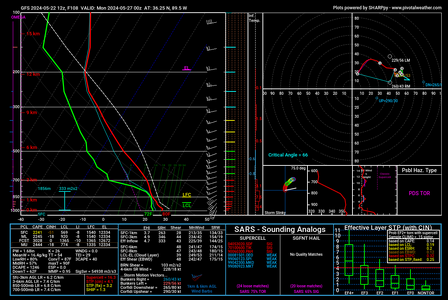
I cherry picked this GFS sounding from the MO bootheel at 00Z Monday:05272024 00Z MO Bootheel.png
 
After finally having a chance to sit down and look more in depth, it appears that a viable warm front target may be in play north of Indy. How far north seems to be a point of contention between different models, but it's enough of a signal that I am already making plans to be out chasing that day, assuming it verifies. The big concern for me at the moment is early convection, but as we saw both on 3/14 (which I missed due to commitments I had that evening) and 5/7 (which I did chase and got three tornadoes), that's not necessarily the setup killer that it's often assumed to be. GFS tends to want it further south, Euro wants it up in Michigan, and the NAM is somewhere in between the two.

Either way, something to keep an eye of since I'll be completely free Sunday and able to chase, as long as I don't have to go super far in any direction. I was hoping to have the motor on my fuel efficient beater back together by now, but alas I'm waiting on parts and stuck chasing in the truck.
 
Indianapolis 500 race is on Sunday. Something to consider with all the traffic to and from the race. And now to the forecast.

Like today (Friday) an MCS should be in progress across Illinois Sunday morning. It's forecast to push into Indiana. Outflow boundary should drift south of the MCS and WF. Upper-level winds will be strong enough down to the Ohio River. OFB south of there (I-64 Illinois) would get into weaker upper support and poor terrain.

Thanks to a stronger overall system compared to Friday, and almost all models progging a second short-wave heading into 00Z Monday, Sunday afternoon should redevelop along outflow boundaries and the WF. The cold front is also a possibility, but I much prefer the former boundaries - especially the outflow variety.

Expected target area is between I-70 and I-64 in Illinois. Ideal target is between I-72 and I-70 but I have a feeling the outflow will settle farther south than that. We'll see.
 
For some reason I did not see this thread had already begun and mistakenly started another one. Feel free to delete that. Will post what that thread started with here:

Trends and model signals are alluding to potentially another warm frontal boundary-style setup for a discrete supercell thunderstorm mode on an arching boundary for portions of Northern Indiana and into the very southern tier of L. Michigan south of I-94 by late PM into early Sunday evening. 06z GFS squashes this idea and keeps the WF boundary, ample moisture, theta-e and MUCAPE's [that exceed 3000 J/kg] well south in around I-70. There certainly has been more model-to-model consistency with that forecast lean. More geospatial alignment [for potential SVR] between ECMWF and NAM 3KM this morning along with ample mid/upper level support [diffluent split evident at h500] hint at a tornado day somewhere in the "northern" zone [N. Indiana/Michiana/SWL. MI]. Obviously the deeper moisture, CAPEs, wind fields and assorted parameters are quite ample for a PM severe/tornado event in S. IL into C. IN and N. KY, already well advertised by the SWODY3.

I would prefer not to have another strong/significant tornado event close to, if not a top the home front... yet this pattern, inbound energy and timing are too eerily similar. Will watch how this actually evolves and expand further as Sunday approaches.
 
One thing I have been guilty of twice now this year is underestimating the ability of a warm front to pull north following midday convection. Both on 3/14 and 5/7, a midday QLCS rolled through northeast Indiana and exited into Ohio by 1300 local time. In both instances, the warm front surged north before stabilizing in time for the second round of convection that ultimately produced tornadoes. Fortunately, on 5/7, I was able to react and get out the door in time to run up to Michigan. From what I've seen to this point, it appears that this will mimic those two days, but with much stronger synoptics, better upper level support, and much stronger instability.

Like Blake mentioned, I've been seeing a lot of indications of a warm front boundary draping along or parallel to the IN/MI border, and surface winds appear to be backed leading up to the warm front. While the GFS does seem to keep the warm front down along the I-70 corridor, it also presents a warm front orientation that's out of line with the other models that are in range at this point.

Ultimately, my plan is to find the warm front or a boundary, and go from there. I will grant that my chase style favors that, so it does fit in with my biases. With that said, I don't see a true dryline out ahead of the cold front, so I do genuinely think the best shot for tornadoes will be either along the warm front or near the surface low in Illinois (assuming the SL is in Illinois as opposed to pulling up into Wisconsin or over Lake Michigan as some runs have depicted).
 
More consistency regarding potential outcomes for Sunday afternoon and early evening are trending more for the southerly route [Indiana] with the inbound low and energy wave from the Plains, with lots of sand still in the forecast ointment. Indiana and points west towards SW Illinois [I-70 corridor] trend more likely to keep the higher parameter space and greater likelihood of some type of SVR event. A cross-comparison of the many flavors of CAMs this morning alludes to a significant wind event with embedded tornadic vortices.

NAM, NAM3K [now in better alignment with other short-range models] and ECMWF still take the inbound low more north towards S. Wisconsin and cast the warm front north with it. The warm front is still suggested to make it up to the MI-IN border. A far higher and eyebrow raising parameter space has since backed way off from 24-hours prior, yet there still are suggestions of 1900 to 2200+ J/kg’s of MUCAPE’s along a warm sector arch anywhere from Central towards NW Indiana via NAM3K. Will have to see what actually evolves tomorrow morning/midday with the ejecting Plains wave/convection in regards to what may happen in the northern sector.

For storm observing, the northern zone [N.IN-S MI] remains questionable nor does it flash a repeat of 5/7 synoptically. Central Indiana could have a mesoscale surprise [tornado or two] while the southern zone from Illinois [STL] east towards Evansville [SW Indiana] and north towards Bloomington trend as the more likely zone for SVR/TORs, but in far more forested terrain, with storm modes suggesting a big straight line wind event.
 
Last edited:
Looking at things this morning, it looks like an InstaLine for Illinois which will proceed south and east. At this point, I don't have a whole lot of confidence in there being a chaseable tornado setup with any of this. Everything I'm seeing now indicates a mid to late afternoon QLCS making it through northern Indiana, with little or no shot at anything developing out ahead of it. I also don't have any confidence in discrete development for the Illinois target.

I'll still check obs and satellite in the morning, but for now, I don't see enough to get me out the door and burn a couple hundred bucks in gas.
 
Complex and quickly-changing forecast for tomorrow. Just in the past couple of hours my plans have changed drastically. At McAlister OK on my way north, I was planning for an all-night drive to St. Louis for what looked like a monster bow echo wind event riding the instability gradient southeastward in the morning. But since then, the entire state of Missouri has bloomed with convection - which means that the effective warm front will be much farther west. That means not only no bow echo (phew, thankfully no all-nighter) but the focus for supercells later may be much farther west and south

The outflow boundary from this overnight activity should be the best play tomorrow, more specifically any east-west oriented part of it, wherever that ends up. That could be Arkansas or Missouri. Staying in Marshfield MO tonight and will reevaluate in the morning.
 
Last edited:
Complex and quickly-changing forecast for tomorrow. Just in the past couple of hours my plans have changed drastically. At McAlister OK on my way north, I was planning for an all-night drive to St. Louis for what looked like a monster bow echo wind event riding the instability gradient southeastward in the morning. But since then, the entire state of Missouri has bloomed with convection - which means that the effective warm front will be much farther west. That means not only no bow echo (phew, thankfully no all-nighter) but the focus for supercells later may be much farther west and south

The outflow boundary from this overnight activity should be the best play tomorrow, more specifically any east-west oriented part of it, wherever that ends up. That could be Arkansas or Missouri. Staying in Marshfield MO tonight and will reevaluate in the morning.

Unfortunately for me, and as per the SPC's 13Z update, this has significantly reduced the tornado threat east of St. Louis into Illinois/WC-SW IN where the OFB was originally thought to be most likely to set up and my target for the day. Coming from Madison, I have no desire to go all the way into the jungles of MO/AR so a down day it is.
 
I'm terrible at locating boundaries when they're not obvious on satellite, radar and surface obs, but it looks like the OFB from last night is just south of the MO/AR border per SPC mesoanalysis. Winds are turning southerly quickly this morning, so that should lift north somewhat. CAMs fire supercells both north of and on this boundary by 5PM somewhere between St. Louis and Cape Girardeau. Good upper level flow though it is mostly unidirectional above the surface. I'm going to play the OFB where storms are on it at 6-7pm in more workable terrain, which would be on the Illinois side of the river if storms can hold off that long. I'm heading to Arnold, MO to reevaluate, thinking of going south from there unless something changes between now and then.
 
Latest HRRR and the abundance of sunshine in Illinois (despite overcast and steady rain here all morning and early afternoon) has me thinking "Not so fast" to my previous, despite SPC's lack of even a 2% tornado contour in NE-NC IL/SE WI on the current outlook.
 
I opted out on today, but now might have to check out the "<2% tornado probability" in SE Wisconsin/NE Illinois this evening. As the low rotates though, 500-1000 MLCAPE might nose into the region coupled with a veering wind profile. Maybe some 1km SRH >150. Skies are clearing in northern IL now. Lapse rates overall are not impressive, but SPC mesoscale analysis shows 3km CAPE reaching 100+j/kg and some good surface vorticity provided by the low. 🤷‍♂️I live so close I will have to go for a mini chase later.
 
The environment across SE MO, W TN, and NE AR has rejuvenated. The OFB has drifted northward into a pseudo-front and a prefrontal wind shift noted on vis sat is drifting southeast ahead of the main cold front. That creates a pseudo-triple point across SE MO that will probably be the focus for convective development across the greatest risk area although additional storms are likely closer to I-70/I-44 invo the cold front. This is becoming a stronger tornado threat due to backed winds, instability and ample SRH. It could be a long night for this region. I am currently in Poplar Bluff, MO monitoring vis satellite. Storms look to be a mixed bag of discrete supercells and QLCS structures but I'd expect the tornado potential to continue into tonight across S IL and W TN as the squall line races southeast.
 
Think the outflow boundary/effective front is the obvious play, but I can't ignore a supercell coming right through my city in a pretty potent environment here. Winds were badly veered earlier, but are rapidly backing ahead of this storm. Will drop south once the metro area is clear and this storm appears no longer viable.
 
Back
Top