• A friendly and periodic reminder of the rules we use for fostering high SNR and quality conversation and interaction at Stormtrack: Forum rules

    P.S. - Nothing specific happened to prompt this message! No one is in trouble, there are no flame wars in effect, nor any inappropriate conversation ongoing. This is being posted sitewide as a casual refresher.

2024-04-27 EVENT: TX/OK/KS/MO/IA

A complicated and muddy forecast analysis this morning with some atmospheric hints already to shape up. Will keep this brief. Currently in the Overland Park/KCI region with a FFZ [forecast focus zone] of north-central Oklahoma northeast to the Kansas border [Blackwell/I-35 towards Winfield] for mid/late afternoon, in favor for surface recovery and convective re-generation along a proposed outflow boundary hinted by several CAM’s. In real-time, the tornado warned supercellular convection, presently from Enid SW to Elk City, will be interesting to watch evolve; along with the mesoscale environment and attendant recovery as those storms populate northeastward into Kansas.

The 12Z OUN upper air sounding [actual, not simulated] is "loud and clear" in terms of potential tornado production for however the atmosphere evolves in NC/NE OKLA and SE Kansas today. Would be interested to see if a special sounding is released at ITC or TUL. Another region of potential interest is closer [to my present location] along Highway 75 from Osage City to Yates Center, KS for a rapid re-evolution with the present convection moving northeast for later today. All is rapidly materializing for a classic, frustrating high-end potential day either way. Shall see what transpires.

Will note for anyone chasing in Southeastern Kansas; numerous local and highway zones in specific areas [such as HW 59 north of Parsons and east of Chanute] were closed on Friday, likely due to flooding. Wise to keep a heads up on that aspect today! Good luck to all out and be safe. Busy day ahead!
 
Dan are you not concerned about the storms to the South Holton moisture to the north? I just drove through Ottawa and I'm heading down to get on the Storm by Enid I feel the parameters are coming together pretty good down there as opposed to Kansas
So far, it looks like those aren't surging east too quickly, so hopefully 50 miles or so north of the border east of 35 will remain viable. The anvil blowoff from that complex is more concerning now - in the past hour, it's really expanded east. I'm also not a fan of hours-old established blobs that eventually decide to go tornadic, as it seems they are more likely to be HP at that point. I'd prefer a new storm somewhere east of the current activity that will interact with the OFB that Jeff alluded to (although it's not as easy to pick out now on vis/radar). The HRRR hints at some lead storms firing down along I-40 west of OKC that may be players in that regard as they approach the KS border. I'm going to go ahead and drop south just to see what this current storm passing south of Wichita will do. Not expecting it to be a show, but at least it provides a position for several options later.
 
Northeastern Kansas low level winds should not be impeded by the convection in south-central Kansas, at least not before the NE KS stuff can get going and get rooted. And the 70/60 Tor watch is out.

Northwest Missouri should be considered. It's still decent terrain. Little hilly coming out of the Missouri River Valley; then, it gets decent again.
 
Just an analysis of what I currently see:
The cloud cover overspreading C KS in response to the building convective cluster across N OK is concerning as far as getting widespread high intensity storms in C/NC KS later today. I would bet that all areas along and south of I-70 have basically reached their daytime high by now and will not destabilize any further. Thus, they're dependent on kinematic disturbances for CI from here on out, at least until the larger forcing for ascent with the wave arrives this evening (after which, who knows what the thermodynamics will look like). They're already at 2000-3000 MLCAPE in that area, with 40-60 kts of effective shear, so the environment looks good for any updraft that goes.

EXCEPT...the 0-3-km shear field doesn't presently resemble an outbreak look to me:
Screenshot 2024-04-27 at 11-30-16 SPC Hourly Mesoscale Analysis.png
I'm not sure what's causing that dearth of shear in S/C KS, nor if the increased shear in NC OK is causing the convection there or being caused by it.
The corresponding 0-3-km SRH field does not look particularly impressive. Effective SRH also looks meager. I'm sure those values will increase throughout the day as the upper level disturbance moves over the area and the wind fields respond. Ultimately, storm evolution will depend on the existing coverage by the time the wind fields improve. Will the storm mode still be cellular? Will there be large regions that have been convectively overturned? That is my concern especially with C/NC KS. E/SE KS through C/E OK look to remain open for a few hours.

The latest HRRR runs suggest the best show will develop SSW of the existing convection along the dryline from W OK into NW TX through 00Z, with little to no sustained open warm sector development east of there. Storm coverage may end up being pretty high, which may end up resulting in unfavorable interference and competition in determining which storm(s) will become dominant. The biggest UH signals continue to be with the extension of the existing convection as it evolves through E/SE KS later on, though, which may end up being the place to be.
 
WoFS forecasts are now rolling in. Only the first cycle (17Z init) is partway done, but it definitely is capturing the existing activity and evolving it over the next few hours.

Below is the ensemble max 0-2-km UH (not 2-5 km!). It's a better proxy for which storms will feature low-level mesocyclones (not high enough resolution to depict actual tornadoes). Looks like this run wants to take the storm currently W of Manhattan and go nuts with it. The remainder of the region is a bit more tempered (although 40-50 m2/s2 is probably still suggestive of a solid low-level meso, i.e., NC OK).

This run is only out 2.5 hrs right now, so it doesn't yet contain any of the OK activity south of there.
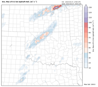
uh_0to2__swath__perc_max.wofs.f00215.png
 
Just an analysis of what I currently see:
The cloud cover overspreading C KS in response to the building convective cluster across N OK is concerning as far as getting widespread high intensity storms in C/NC KS later today. I would bet that all areas along and south of I-70 have basically reached their daytime high by now and will not destabilize any further. Thus, they're dependent on kinematic disturbances for CI from here on out, at least until the larger forcing for ascent with the wave arrives this evening (after which, who knows what the thermodynamics will look like). They're already at 2000-3000 MLCAPE in that area, with 40-60 kts of effective shear, so the environment looks good for any updraft that goes.

EXCEPT...the 0-3-km shear field doesn't presently resemble an outbreak look to me:
View attachment 25073
I'm not sure what's causing that dearth of shear in S/C KS, nor if the increased shear in NC OK is causing the convection there or being caused by it.
The corresponding 0-3-km SRH field does not look particularly impressive. Effective SRH also looks meager. I'm sure those values will increase throughout the day as the upper level disturbance moves over the area and the wind fields respond. Ultimately, storm evolution will depend on the existing coverage by the time the wind fields improve. Will the storm mode still be cellular? Will there be large regions that have been convectively overturned? That is my concern especially with C/NC KS. E/SE KS through C/E OK look to remain open for a few hours.

The latest HRRR runs suggest the best show will develop SSW of the existing convection along the dryline from W OK into NW TX through 00Z, with little to no sustained open warm sector development east of there. Storm coverage may end up being pretty high, which may end up resulting in unfavorable interference and competition in determining which storm(s) will become dominant. The biggest UH signals continue to be with the extension of the existing convection as it evolves through E/SE KS later on, though, which may end up being the place to be.
Storm west of Manhattan now tornado warned. Correlation coefficient showed debris. I'm sitting in Coffey County, KS. 76 degrees with a 66 dewpoint. We will see what happens.
 
I'm pessimistic so far. Storm east of Wichita is bowing with outflow far ahead of its southern flank. That's a hard thing to overcome. Fearing similar evolution upstream.
 
So far this event seems to be unfolding in a manner very similar to NSSL's MPAS runs from last night. That arc formed by the morning storms that is now across KS bears an uncanny resemblance to the forecast composite reflectivity from MPAS .

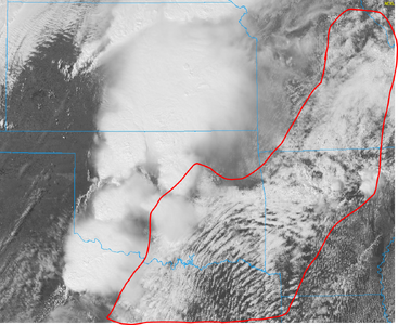
The other thing I'll note is that SPC's mesoanalysis page for CIN appears to be underdoing the inhibition. This recent visible satellite imagery suggests to me that most of the moderate risk area is still in a fairly stable regime. Those clouds do not look like TCu getting ready to blow...they look like stratus or stratocumulus.
stable.png
 
In addition, the 19Z special sounding at Norman (which appeared to be launched into a part of a thunderstorm given complete saturation starting around 500 mb and cut off not long above that) still showed a small capping inversion based just below 700 mb. That is probably the thing holding back sustained storm initiation in C OK. But that inversion definitely is getting lifted out. Will it get removed in time for discrete cell initiation? We shall see.
 
No view of the Dexter KS circulation/likely tornado. As expected, storm is too HP. DOW armada is here scanning this storm. I'm moving south.
 
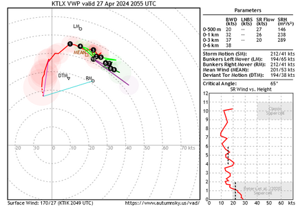
Recent VAD VWP from KTLX shows very little shear in the 1-6-km layer (yes, shear in 0-1 km is awesome). But this suggests that supercell dynamics are not easily happening and probably explains the inability of storms to remain substantially supercellular.
 

Attachments

  • canvas.png
    canvas.png
    70.9 KB · Views: 9
I am curious to see if the DL fires off a few new storms in the next few hours. I don't see any new TCU in the open warm sector at the open the moment.
 
Really cranking now. I can't remember seeing training tornadic supercells like what is happening in the Ardmore area now or was happening in Southern KS earlier. Large wedge appears to be taking aim at Bearden, OK. Chasers on it seeing power flashes.
 
Unfortunately, both from a chase standpoint and for the people of Oklahoma, this event definitely lived up to expectations in central OK, but mainly after dark. I ended up my chase and am staying in El Reno, and it pretty much went wild once the sun set south and east of OKC, including in the southeast parts of the metro area.. Dan, your concerns about chasing near OKC on a Saturday definitely verified, as I will have photographic evidence of from the Binger/Hinton storm once I get around to posting a chase report. Massive backup trying to get to a rain-wrapped meso that ended up not producing. Large tornadoes still ongoing now east of OKC. Edit: I see Warren's post that appeared while I was typing my post. Yes, kudos to SPC.
 
Unfortunately, both from a chase standpoint and for the people of Oklahoma, this event definitely lived up to expectations in central OK, but mainly after dark. I ended up my chase and am staying in El Reno, and it pretty much went wild once the sun set south and east of OKC, including in the southeast parts of the metro area.. Dan, your concerns about chasing near OKC on a Saturday definitely verified, as I will have photographic evidence of from the Binger/Hinton storm once I get around to posting a chase report. Massive backup trying to get to a rain-wrapped meso that ended up not producing. Large tornadoes still ongoing now east of OKC. Edit: I see Warren's post that appeared while I was typing my post. Yes, kudos to SPC.
The traffic jam in Hinton wound up being the end of my chase as well. I've seen chaser convergence before, but that was wild. It was the first time I can remember being irritated by the number of chasers. And half the folks seemed like sightseeing locals with kids and dogs loaded up in their cars.
 
The traffic jam in Hinton wound up being the end of my chase as well. I've seen chaser convergence before, but that was wild. It was the first time I can remember being irritated by the number of chasers. And half the folks seemed like sightseeing locals with kids and dogs loaded up in their cars.

One of the reasons I completely avoid chasing near OKC now days. Getting trapped in traffic during El Reno was enough.
 
Back
Top