State of the Chase Season 2023

Status
Not open for further replies.
Well we are now in the period that we had been eyeing, i.e. the Saturday start to some renewed activity after a pretty dead week, and the Saturday-Wednesday period that I had been considering going back out.

It looks worse than ever. Glad I made the choice to bail on a second trip, but no less pissed off about how the season worked out and forced me to squander what could have been my longest chase trip by coming home last weekend instead of staying until June 15.

I have a number of work/family commitments from the 16th through the 26th, and after that it’s highly doubtful I could make another Plains trip even if a northern or Midwest season does come to fruition, because I have additional time off in July for a family vacation and it’s just too much time away from work within a short period. So unless there‘s a surprise fall event, I guess Storm Chase 2023 is pretty much in the books for me.

Who knows, maybe my new remote work arrangement will allow me to do my first hurricane chase later this summer.
 
As a relatively new chaser, this thread is bumming me out. I was on the Ottumwa wedge/twins earlier this year, but was a hurculean effort to obtain, and not sure how much of that type of chasing I can do being located in Colorado. It was also my first real tornado outside of a birdfart or 2 in the previous few years, or an obstructed view of the New Boston wedge last Nov. I put more time in this year than I ever have, and it's paid off with a few nice photogenics, but also not sure how much I can do this in future and still be on good side with work.

In some ways I'm lucky only having started chasing in 2020 cause I don't know what an easy chase/forecast is like. It's almost always a frantic night-before rush out the door to the middle of nowhere on a slight hope of something. That is chasing to me, but even still, it's a taxing proposition physically, financially, and mentally that I'm not sure how much I can keep up.

I'll still keep chasing, but if everything moves to dixie, I'm just not going to be there. Hate chasing there for all of the obvious reasons, and just not going to waste my time in future there considering the effort/cost it takes to get there.

Not sure what to do. Maybe we can reverse all the wind farms in Kansas to speed up the lower level shear/jet and push the moisture northwards.

Funny enough, Tony, I'm from Colorado myself -born and raised on a farm 20 miles north of Fort Morgan out near the village of New Raymer. I graduated from FMHS in '08 and went to Metro State for Photojournalism (almost went for a Met minor but the department chair at the time, Dr Sam Ng, was VERY anti-chasing and threatened to flunk anyone who missed his classes for chasing, so I dropped the program after one semester and switched to a Digital Media minor. Ironically enough, he now is co lead on chasing field trips led by my good friend Dr. Scott Landolt, who finally convinced him of the value of in situ severe weather forecasting and observing real time supercell and tornadogenesis to the students).

I moved out of state in '12 and I missed the great run of tornado days in eastern Colorado in '15 and '16 (Simla, Eads, Vona/Cope, Wray) when I was living in Minnesota and Iowa respectively (something that I will always regret, I should have quit both my shitty jobs I was working and gone, I ended up quitting both of them anyways not long after), but I did move back just in time to get a killer chase and seven tornadoes on my half birthday on 6/12/17 from Grover to north of Bayard NE, and another couple of great High Plains days in Wyoming on 5/27/18 and 5/28/18. Since then? It's been a crapshoot in the High Plains. I was out of the country in New Zealand/Australia for the 2019 season, and that was during the worst drought in both country's respective history, so I barely saw any storms during my time there - a real gut punch as I had always wanted to do some chasing down under.

I will say that now that we are moving into this El Nino pattern, we should see a more favorable pattern for High Plains severe evolve as we move through the summer months. La Nina is a major buzzkill for the majority of the Traditional Alley but especially for the High Plains - see 20-22's never ending western ridging and non existent flow as a prime example.

As a point of the favorability shown by the transition to an El Nino pattern, east NM/TX Panhandle have been pretty damn great this year, even under marginal ridging conditions, when they have been almost severe weather free since 2019. So don't totally throw in the towel for future opportunities, bubba, even in the proverbial backyard. They may be less synoptically evident far ahead, but they will still come. CO/WY always manages to eke out some pleasant surprises almost every year without fail.

Looking at this upcoming pattern, I would say that somewhere in the western South Plains tomorrow evening; GFS says southeast CO/western OK Panhandle/ north TX Panhandle, NAM says concentrated threat around AMA vicinity. Looks like there will be a solid ribbon of upper 50's to mid 60's dews that advects into the region ahead of the trough digging into southern CA, and this area is far enough removed from that pesky upper level Great Lakes low that is veering the upper level flow and will ultimately squash the oncoming trough from developing its full potential. It would be dependent on a lobe of energy transiting across in a timely fashion - something that has been a consistent issue this year is that the models seem to have a poor handle on the timing of upper level support ejection. It's consistently been 4-12 hours late the entire season. It would also hinge on how much the atmosphere recovers after the morning convection.

Monday could be conditionally significant in the ABI vicinity, with extreme CAPE values developing in the 4500-6500 range(!) across northwest Texas, but that 700 mb cap is mighty fierce. Though the NAM develops an intense 40 kt LLJ across central TX by 0z, and the lead wave is moving out with 70 kts of bulk shear with SRH in the 300-500+ range concentrated in the Big Country. NAM and 3KM NAM both develop a couple of intense supercells in this region. I'd say that this bears monitoring to see how it trends by tomorrow evening.

Tuesday is more nonsense just west of and into the Metroplex, surface flow looks somewhat anemic especially compared to Monday and wouldn't be surprised to see some major HP hail machines, but tornado potential would be limited to storms interacting with existing boundaries from previous nights convection.

The rest of the week looks to be the re-establishment of a ridging pattern so Wednesday-Friday appear to be down days, at least temporarily, with another wave emerging out of the northern stream into WY/SD by the weekend that might have some solid potential for central/northern Plains severe as we move into Father's Day and beyond.

I'm not real enthused about making a 10 hour dash to northwest TX from KC for Monday, but that area has been obscenely consistent this year, and I saw one of my best storms of my entire career down there a couple weeks ago in a more marginal environvment, and I've learned that when Ma Nature gets in a rut, you can't ignore her. This is a West Texas year, clearly, so I might expedite my repairs on my chase vehicle tomorrow and run down there if it continues to improve and the HRRR has a similar outcome depicted when it gets in range tonight.

Otherwise, my eyes are pretty locked on the Father's Day weekend trough that may finally offer decent opportunities in the NE/IA/KS/MO vicinity in the Sunday-Tuesday timeframe.
 
If I lived in Colorado my decision is easy. Chase close to home. Hope for some DCVZ magic. Be open to most of the southern High Plains. This is the season for mesoscale accidents in Colorado. Maybe not big grinders, but photogenic land spouts are just as rewarding.

Sun/Mon SPC has slight and marginal risks on the High Plains. LLJ forecast is a little tricky, no surprise with major forcing elsewhere. However the 500 mb flow is consistent. One just waits for forecasts and details to come into focus.

Back to travel chasing, yeah @Jason N it is like playing Operation or whack-a-mole. See Jason's picture post last page. Sunday Mid-South? Nah, I'd rather Raton Mesa in Colorado. Mid-South may have a surprise on the outflow boundary, but the OFB would have to stay pretty intact because the low levels are veered off. If one could get to Colorado today, start there Sunday. Unfortunately that's not me.

Monday I'd roll the dice on the High Plains over anything in the South. The Delta Tuesday? I can't believe I'm even remotely considering that in June. See my location in Tenn. Tuesday could be a rest day High Plains. Midweek could be more High Plains WY/CO/NM, just based on new 500 mb flow. Details are TBD.

Bottom line: I like the High Plains more than the South, obviously. However I don't feel like it is quite time to travel. Andrew Pritchard tweeted a thread about the following week (June 18+). It is getting late in the fourth quarter, but maybe 2023 will have overtime after the meh time.
 
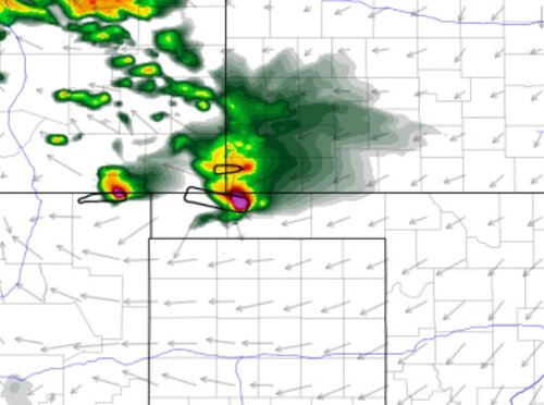
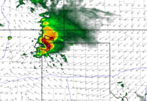
18Z HRRR/Nam Nest for tomorrow 00Z could be the best place for good structure tomorrow, previous NAM runs had this as well solution as well. The LFC's are unsurpisingly high, but I think that cleans up the bottom end of the storm base, the cap might be an issue but initiation should occur outside of pueblo CO. As they move east into the panhandle, LLJ looks to pick up from the e-ese to 25-35kt.. so the inflow could be decent close to magic hour and beyond, not to mention the hodograph looks pretty decent as well in the 1st 3km with some apparent SVC. Well, this is where I had been panning to be a few days ago tomorrow. I hope someone takes a shot at it and see's what happens. I'll call it in advance, they go to 5% lol 🤷‍♂️
'
 

Attachments

  • tomorrow evening.jpg
    tomorrow evening.jpg
    57.3 KB · Views: 0
  • NNest tomorrow.jpg
    NNest tomorrow.jpg
    61.2 KB · Views: 0
Well, someone humbled me this morning at the SPC. now its No percent , Booooo!! .. I'd still go anyway! ... somewhere between Amarillo to clayton is where I would be hanging out for a north or south option today, just to see what happens. There's a zone there, and I think its the most potential for today to see, ''something"
 
Last edited:
@Mark Farnik I appreciate your thoughtful post and glad to get some other veterans back to being active here. I hope you will continue to post and encourage others to do the same. Stormtrack has a rich heritage. Its niche focus and curation really should make it the central gathering place for all chasers, rather than the cesspool of social media with its random algorithmically-generated feeds that mix chasing and non-chasing topics.

But that's not what this post is about; I wanted to write a bit more about the state we find ourselves in, and perhaps offer some alternative perspective to lighten the mood and bring some optimism.

I am right there with everyone complaining about 2023, and feeling like it is just the most recent year of what has become an annual tradition, like rooting for a losing sports team and saying "better luck next year." But I have to wonder about a few things that may be unduly influencing our negative perception of the seemingly downward trend in chasing prospects. I'm not saying I know the answer - just throwing it out there for consideration:

1. How much of this perception is due to nostalgia bias - i.e., thinking the past is better than it was, and remembering the "good" but not the "bad"?
2. How much of this perception is due to recency bias - i.e., allowing recent impressions to overshadow the past?
3. If chasing prospects are really getting worse, how much is due to climate change (implying that it will not improve during our lifetimes) versus longer-term but non-permanent - perhaps decadal - cycles, such as is now known to exist for hurricane activity?

Most of our perception about the decline in chasing prospects is anecdotal. It is very difficult to prove empirically, even with all the tornado statistics that exist, because of the subjectivity in what constitutes a good chaseable event or a good season. And there are no statistics to my knowledge on photogenic vs non-photogenic tornados, classic vs LP vs HP supercells, supercells with good structure and grungy structure, etc. As the seasons accumulate, what one remembers as a "good" year could be because of just one particular day, without regard to the rest of the season (i.e., nostalgia bias).

For chase vacationers, a season that is "good" from start to finish certainly increases the probability of a good one or two week chase vacation. But every season, no matter how good it is judged to be overall, has good weeks and bad weeks. It's the luck of the draw that determines what you end up with on a chase vacation. I love to use 2013 as an example of this. Although Mark includes it in his range of good years from 2007-2014, my recollection is that chasers were complaining how bad the season was because it was pretty dead except for the last two weeks of May. But if those were the two weeks of your chase vacation, you pretty much hit the jackpot.

I started chasing in 1996. When I sat down to write this, I briefly considered each year. Yes, believe it or not, I do have a pretty good recollection of each and every year. Not the details, but the essence, and the overall impression of which years were good and which years were not. My own nostalgia bias may mean that what I call a "good" year was really not good. And maybe some of the years I call "bad" were only because of when my trip was scheduled, or because of my own failure. I did not take the time to go back into my notes and journals for verification or for details. But I think that's OK, because *perception* is what we are really talking about here isn't it?

I will spare everyone the details of each of the 25 years I chased from 1996 to 2023 (I missed three years, when my children were born and the Covid year), and will instead just offer a summary. Again, I admit some of what I consider "good" vs "bad" is likely driven by the timing of my chase vacation, and/or by my own success or failure. But that's also part of the point - so much more matters than just the quality of the weather itself.

My very first chase trip was on a tour the first two weeks of June in 1996. (A year after some of the bigger events had happened in Pampa, Friona, Dimmitt, etc.; I seem to remember there had been a pretty famous first week of June 1995.) Even back in 1996, it was a pretty dead pattern. No tornado, and probably just a few supercell days. In 1997 I was only able to chase for a week; I remember there was an outbreak day in the area west of Wichita (e.g., Harper County); that was my first tornado day. From 1998 through 2002, I only saw two tornados (Basset, NE in 1999, my first year chasing independently after three years of tours, and Trinidad in 2001). I don't remember there being regional outbreaks in any of these years. 2003 was an active year that I unfortunately had to miss, but I remember most of the activity being in early May - not a time I would normally have scheduled my trip anyway. 2004 was good, but 2005 and 2006 were not. So that's about 10 years of chasing before the period Mark identifies as being pretty great, and I would say that this particular stretch of 10 or so years from 1996-2006 was pretty poor overall, with only about one-third of them leaving me with a positive impression. Again, yes, somewhat anecdotal, but my point is I think that affects impressions for all of us.

So now we're in the 2007-2014 period that Mark highlights. I missed 2007, but I believe that was another early-May year that shut down after that. Anyway, yeah, I have to agree, if I look at a simple tally of my own "positive" and "negative" trips during the seven years I chased, I'd say all were pretty good, with 2009 the only exception - isn't that the year even VORTEX couldn't get anything until June in Wyoming? I'm calling years "good" only because I saw tornados (including 2012 - Lacrosse KS). I can't recall how good the "other days" were. In my recollection, there were higher-end outbreaks only in 2007, 2011 and 2013. My 2010 highlight was Campo, and that was a mesoscale event; the rest of the trip was a disappointment, although I think it is generally perceived as a good year. I don't remember anything good during my trip in 2014, but that again could have just been the result of when it took place.

And of course I agree since then it has pretty much sucked - with the exception of 2016, but those were also mesoscale events (Dodge City, Chapman). Yet I had a personal top-three chase with Selden KS in 2021. And I remember 2019 having a few good events that I just failed to capitalize on.

So as I look back at my own chasing career, I agree with Mark's favorable characterization of 2007-2014 (or at least through 2013), and with his unfavorable view of the years since then. But I would add that 1996 through 2006 were also not that great, and may not have been too much better than the last ten years have been. Hence my theory on decadal cycles: I am approaching 30 years of chasing, and I can identify a poor decade, followed by a good decade, and now another poor decade. Which would imply the pendulum is about to turn again, if my small sample has any predictive merit.

Many chasers seem frustrated when there is a lack of synoptically-evident events and reliance is upon the mesoscale. However, most of my personal best events have been mesoscale. I have actually chased very few outbreak days, whether due to unfortunate scheduling, or just lack of such days within the peak season.

In summary, I guess my points are: So much of our perception is colored by our own nostalgia bias or recency bias. I might be totally off base with my characterizations of the different seasons, but that only means that every other chaser probably is too. All of our perceptions are colored by our own results, and there really is very little objective evidence for any of this. None of it really matters, and it is not going to make me less enthusiastic or hopeful as each season approaches. Don't lose hope! There will be storms, and there are gems to be found in just about every season. Try to appreciate whatever you do get to see and experience - believe me, I get it, it is natural for the personal bar of what defines "success" to get higher the more we have already seen... But it is so important, and a life lesson, to try to appreciate the lower-end phenomena too - something I have been able to rediscover the past couple of years only by bringing my son with me and seeing things fresh through his eyes.
 
Last edited:
I am approaching 30 years of chasing, and I can identify a poor decade, followed by a good decade, and now another poor decade. Which would imply the pendulum is about to turn again, if my small sample has any predictive merit.

Funny enough, this just happens to coincide with the release of the Twisters movie next year. When Twister was released in 1996, it brought a lot of new storm chasers to the hobby. That happened again 11 years later in 2007 when Storm Chasers was released (which ran 5 years through 2011). And now 13 years later we might get another boost from the Twisters movie. If an influx of new chasers coincides with an increase in tornado activity, that could spell trouble for chaser convergence (which I feel like has subsided considerably over the past few years). I can handle 100 chasers spread out over 20 square miles. But I don't look forward to the days of 1,000 chasers all on the same storm again.

That said, I don't want to get too far off topic as this is a 2023 chase season thread.

I am personally looking forward to some July / August El Nino Colorado action this year. Good road networks, flat terrain, and 30kt shear is all you need to produce some great photogenic tornados. Maybe we'll even get twin tornados again like we did in 2018.
 
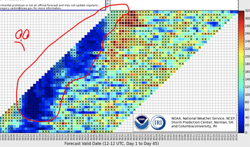
I think it's safe to say the Southern Plains chase season is quickly coming to an end, with a summer time pattern setting-up as supported by the NCEP models. The attached graphic says it all, as potentially exciting days were forecast, only to have them vanish right in front of our eyes. No doubt there will **likely** be additional chances and a few sneak attacks, but what a dud storm season overall.

crap.jpgin the Northern
 
Yeah, this week looked like it was going to be Luciano Pavoratti for the '23 season, and, uh, it turned it to actually be Elmer Fudd in 'What's Opera, Doc?'. 'WOE, BWUNHILDAAAAAA', to paraphrase. Yeesh.

I'm of the opinion that ridiculous unseasonably strong Great Lakes low retrograding south and basically pinching off the ability for the 500 mb trough to fully evolve and eject with that delicious negative tilt as was depicted last week when we were all salivating over what seemed to be on the horizon bears the lion's share of the mousefart outcome from the forecasted lion's roar.

The chiclets have now shifted to end of next weekend to mid next week, as denoted in the graphic that Warren posted bemoaning the vanishment of them this week, and finally will be moving north into a more typical area for severe weather on the cusp of summer. It's discombobulating that we're seeing significant severe weather occurring in the Texas Hill Country in mid June.

I've been driving to freakin' Texas continously for severe weather setups every 3-4 weeks since my birthday, which was 6 MONTHS AGO TODAY and don't get me wrong I'm grateful for what Texas gave me over this period especially this last month, but I'm really ready to be chasing somewhere... other than Texas.

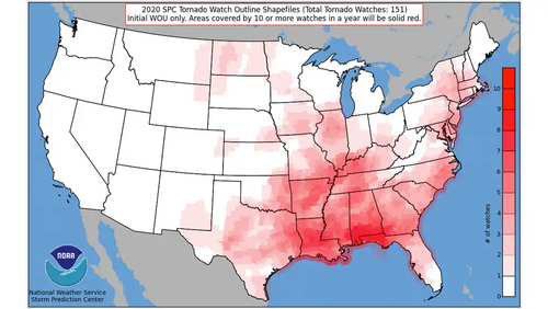
I'm hopeful we'll get at least a few solid Missouri River Valley days, as, notably, there has yet to be a tornado watch over central/eastern Kansas or western Missouri at all this year, which is pretty unusual. The vast majority of the severe weather has been in the High Plains, south of US 412 or north of US 36.

Looking ahead...

18z GFS says that eastern KS/NE could FINALLY get in on some good action around Tuesday/Wednesday of next week, which would be great because it's been utterly dead since mid May and there's been no severe weather of any note within 200 miles either side of KC/Omaha since then. Looks like that 500 mb trough has a nice shortwave that ejects ahead of it as it dives into the central Rockies, before it abruptly rockets north into the western Dakotas late next week and yanks the severe weather threat from the Mid Missouri Valley to the Red River Valley in one day and seems to want to recreate something like 6/14/2010 across Minnesota. But on its heels, another trough seems to develop a bit further south and drag... is that... 60 KNOT SOUTHWEST FLOW heading towards the Central Rockies? Intriguing, even though it's out in Fantasyland.

12z Euro wants to ramp up a brief ridging pattern evolves but it gets sandwiched neatly between what looks to be a fairly potent East Coast trough and a marginally more modest but still very much present Western trough as we head towards the last weekend of June, and have a Revenge of the Sithern,er, Southern Stream early next week, with a stout split flow pattern developing and giving Oklahoma/southern KS another go at some sig severe. It then maintains a Trough West / Ridge South/ Trough East pattern out to 240 hours.

So both the GFS and the Euro has the same general idea about what's coming down the pipeline. I always take note when they are synchronous that far out, because *typically* they are picking up on the signals that will translate to the overall pattern.

I would say 'well that doesn't track for this time of year' but ya know what, 2023 has made it clear that climatological norms, even compared to the last 5-6 years, are not just out the window, they've been yeeted into the next section. We just have to kind of somewhat ignore the calendar at this point and do our best to interpolate the data.

We may have gotten Elmer this week, but my StormSpidey Senses are tingling that the Central/Northern Plains may yet make up for this bizarre whatever the hell you wanna call this pattern we've had ongoing for the last 6 weeks or so, and we may yet hear (and see) a glorious atmospheric performance.
2020 also saw no tornado watches in central/eastern ks. Once is an anomally but twice in 3 years?1686624613463.png
Folks can laugh at me but I have often wondered about the poliferation of wind farms and if there is something we dont really know/understand with their interaction with regards weather. I know there are a pile in the Texas panhandle, Dodge City area, etc. Just something I think about alot as I can see 2 farms from my house and they tried to put in a 3rd but the citizens organized and shot it down. From a clear day on my neighbors hill you can see 3 large wind farms.
 
Folks can laugh at me but I have often wondered about the poliferation of wind farms and if there is something we dont really know/understand with their interaction with regards weather. I know there are a pile in the Texas panhandle, Dodge City area, etc. Just something I think about alot as I can see 2 farms from my house and they tried to put in a 3rd but the citizens organized and shot it down. From a clear day on my neighbors hill you can see 3 large wind farms.

I'm not an expert so I can't say "no, that is not the case", but I think the answer is a little more simple. For decades there have been warnings about changing the climate and now the climate is changing we're looking around wondering why.
 
I'm not an expert so I can't say "no, that is not the case", but I think the answer is a little more simple. For decades there have been warnings about changing the climate and now the climate is changing we're looking around wondering why.

Maybe, but correlation is not causation. I suggested in my long post above that perhaps there are decadal cycles with severe weather, as is now generally accepted to be the case with hurricanes.

I can even see this possibility in the admittedly small sample of my own chase career, with 1996-2006 being similarly inactive as 2015-2023, but a more active period in between. There’s not a lot of talk about 1996-2006 on here because not everyone on ST was chasing back then. I hear the 1980s were great - that was before my time chasing, but I’m sure many of the vets were getting worried about a permanent decline in activity as they got into the early 2000s. I am not referring to whether there is or isn’t climate change, so nobody freak out. I am simply postulating that, even assuming a background of climate change, that may not be the direct cause of the reduced Plains severe weather activity these past years, and we may very well see an uptick in the next few years even as the overall climate continues on whatever track it’s on.

I think it’s human nature to think in terms of years, and to interpret something happening for a number of consecutive years (like reduced good chasing opportunities) as a trend that is going to keep moving in that same direction, instead of realizing that some things can fluctuate within much longer time horizons, such as decades. It’s recency bias - we perceive recent trends (yes, even ten years is “recent” when talking about Plains weather) as representative of some new reality, because we are not looking at longer-term trends (which for weather would have to be decades at a minimum, if not centuries).

I don’t know how we would even assess such a thing for chasing, because it’s not just about tornado frequency, it’s about subjective criteria that are relevant to chasers and other things for which no statistics likely exist, such as storm mode, synoptic vs mesoscale events, regions with open terrain and good road networks, etc.
 
Status
Not open for further replies.
Back
Top