State of the Chase Season: 2016 Edition

Worse than 2012?

So far, yes. 2012 had that nice little setup by Champaign with multiple tornadoes on 5/1/12, and a nice squall line on 5/6/12 that i actually chased. That produced a couple minor touchdowns too. So far in 2016 we have nothing, unless you live near the quad cities and got a backyard funnel on a 0% day
 
Still some significant differences in next weekend's/weeks's forecast between the GFS and Euro, but per 12Z models it's looking a bit better for chaseable days than in runs past. GFS initially has a high amplitude ridge over the central US and a quasi Omega block going on, keeping the initial part of the trough from ejecting out into the plains and trapping it west and north. That eventually breaks down and a final shortwave passes through the central plains Monday and Tuesday. The Euro looks much more favorable for multiple chase days, with a lower amplitude ridge over the plains and multiple short waves rotating around the parent trough starting Saturday. The Euro also deepens the trough during that time and digs it a bit further south which I would have to imagine leads to more favorable setups this time of year. I'm more encouraged for the 21st to 25th than I was yesterday at this time.

Last night's 0z runs of both the GFS and Euro appear to continue their respective trends for late next weekend / early the following week. I am encouraged for this timeframe as well, particularly if the Euro turns out to be more correct. Only question for me at this point is whether I decide to start my chase vacation on Saturday, Sunday or Monday. I will keep monitoring and make a final decision and travel plans by Tuesday or Wednesday of this week.
 
Last night's GFS and ECMWF both indicate a relatively favorable 500mb flow pattern from late this weekend through much of next week. I am planning to make Sat my travel day (flying into DEN) to potentially start chasing on Sun 5/22. On Sat some decent moisture works its way into eastern CO per the GFS, but 500mb winds are just 20 knots as the trough will not have progressed enough eastward. Could be a surprise in CO but not enticing enough for me to miss extra time at work and home to fly out there the day before. By Sun there is better 500mb flow, although my concern is that it won't be co-located with the best moisture. Have not looked in detail beyond that but have seen enough to know I want to get out there and won't delay my trip any longer. The following week of 5/29 looks terrible on the GFS but we all know how meaningless that is (hopefully, in this case). FWIW, the ERTAF shows an "average" week of tornados the week beginning 5/29 so obviously they are seeing some favorable factors that counter my looking at the >10-day GFS in isolation. However, ERTAF shows the week beginning 5/22 as "below average."
 
I looked at the GFS 18Z run on both Tropicaltidbits and TwisterData and here's what I found:


1. There's a ridge over the Mid-MS Valley but it will slowly move northeast into the Great Lakes region and it will slowly begin to break down by early next week. The 500 mb winds become more favorable (as stated above by James) and that western trough moves east a little.


2. Between hours 192 and 204 (wednesday afternoon and evening), look at central OK. Dewpoints are in the upper 70's (78 was the highest I saw), almost 80. I've never seen dewpoints that high in Oklahoma! Not even during El Reno were they that high, as the highest I saw that day was 74! Not only that, but the CAPE exceeds 4000 J/KG! The area extends from just east to OKC and extends southwest to the Red River. The only problem is that the surface winds are out of the southwest. There is also a very slight veer-back (based on the sounding close to Atoka I believe) as well.


Of course, there may be several days of severe weather but that area was something that stood out to me.
 
In contrast to some recent posts, I'm pretty discouraged by what I see in the medium range models for severe/chasing prospects for the near future.

The GFS has been pretty consistent in two things: 1) a western US trough moving in this weekend and staying around for awhile; 2) significant periods of rather pathetic mid-level flow over the Plains.
Regarding #1, the trough seems to sit a few hundred km too far west for optimal severe probs on the plains. The GFS has been consistently showing the good flow for supercells is probably going to remain restricted to the northern high plains, but it also shows the typical issues with a lack of overlap between the good flow and sufficient low level moisture. Good flow may be present over portions of E CO, but again, moisture is a concern, as the dryline will be east of the eastern edge of the good flow. Even though southwesterly flow with jets appears likely over portions of the high plains, there appears to be insufficient eastward progression of this trough and associated mid-level jet stream before a shortwave or two lifts the whole trough up towards Canada and into oblivion. I see one or two moments where locally faster mid-level flow gets over areas like KS/MO/OK, but such mesoscale areas of enhanced flow are all but guaranteed to move around and/or disappear in later forecast cycles. Granted synoptic scale predictability is absent in Fantasyland, but 200+-hr GFS forecasts look absolutely disgusting, looking more like a midsummer pattern featuring very weak flow almost CONUSwide.

Certainly things can and probably will change, and very rich mT air will finally arrive and stay across the central US and reach higher latitudes as is climatologically favored, but I don't see a lot of hope with indications of any sort of larger-scale disturbance at least in the next 7-10 days to favor any sort of widespread tornadic severe threat. Certainly there will be severe weather events since this is the time of year for it, but it appears more to me that we may have already finished the portion of the season featuring longer-range predictable and widespread severe/tornado threats and may be moving into the portion of the year dominated by mesoscale setups that generally don't become imminent or obvious until the day before or the day of.
 
Last edited:
In contrast to some recent posts, I'm pretty discouraged by what I see in the medium range models for severe/chasing prospects for the near future.

The GFS has been pretty consistent in two things: 1) a western US trough moving in this weekend and staying around for awhile; 2) significant periods of rather pathetic mid-level flow over the Plains.
Regarding #1, the trough seems to sit a few hundred km too far west for optimal severe probs on the plains. The GFS has been consistently showing the good flow for supercells is probably going to remain restricted to the northern high plains, but it also shows the typical issues with a lack of overlap between the good flow and sufficient low level moisture. Good flow may be present over portions of E CO, but again, moisture is a concern, as the dryline will be east of the eastern edge of the good flow. Even though southwesterly flow with jets appears likely over portions of the high plains, there appears to be insufficient eastward progression of this trough and associated mid-level jet stream before a shortwave or two lifts the whole trough up towards Canada and into oblivion. I see one or two moments where locally faster mid-level flow gets over areas like KS/MO/OK, but such mesoscale areas of enhanced flow are all but guaranteed to move around and/or disappear in later forecast cycles. Granted synoptic scale predictability is absent in Fantasyland, but 200+-hr GFS forecasts look absolutely disgusting, looking more like a midsummer pattern featuring very weak flow almost CONUSwide.

Certainly things can and probably will change, and very rich mT air will finally arrive and stay across the central US and reach higher latitudes as is climatologically favored, but I don't see a lot of hope with indications of any sort of larger-scale disturbance at least in the next 7-10 days to favor any sort of widespread tornadic severe threat. Certainly there will be severe weather events since this is the time of year for it, but it appears more to me that we may have already finished the portion of the season featuring longer-range predictable and widespread severe/tornado threats and may be moving into the portion of the year dominated by mesoscale setups that generally don't become imminent or obvious until the day before or the day of.

I always enjoy Jeff's posts and agree we have left the period when good setups are synoptically evident days in advance. Yes the winds are weak, but a chaser with a planned chasecation could do worse then find him/herself under several days of SW flow with excellent CAPE in late May. And surprises do happen. Jarrell TX 1997, Bennington KS 2013 and even Campo CO 2010 come to mind.
 
Last edited:
I love the input and the expertise we get on this board. Its highly appreciated.

I also do NOT see any type of widespread or any high risk days coming. Adequate shear overrunning big cape isn't a slam dunk at any point. But I think if you pick your spots right you will get rewarded with a couple good days next week. As Eric said, chasers could do much worse then the type of setup we have coming this week. Big cape will be in place giving potential for a breath of good shear to set off some local nice action somewhere bewtween CO/OK/MS/NE.
 
I always enjoy Jeff's posts and agree we have left the period when good setups are synoptically evident days in advance. Yes the winds are weak, but a chaser with a planned chasecation could do worse then find him/herself under several days of SW flow with excellent CAPE in late May. And surprises do happen. Jarrell TX 1997, Bennington KS 2013 and even Campo CO 2010 come to mind.

Agreed that those types of events happen regularly and probably will this year. I personally do not take chasecations and cannot really justify taking several-day periods off to chase South Dakota from Oklahoma due to finances. Therefore, there was some bias in my post (although I did my best to be objective about it). I'm just very irritated with how this season has gone so far. There's hardly been an event worth chasing, and the best day so far occurred an hour away from me and I didn't chase it. I hate how during the period where we finally had regular trough progression, almost every setup was ruined by veered/weak 700 mb flow or consipicuously weak moisture. So lame.
 
Agreed that those types of events happen regularly and probably will this year. I personally do not take chasecations and cannot really justify taking several-day periods off to chase South Dakota from Oklahoma due to finances. Therefore, there was some bias in my post (although I did my best to be objective about it). I'm just very irritated with how this season has gone so far. There's hardly been an event worth chasing, and the best day so far occurred an hour away from me and I didn't chase it. I hate how during the period where we finally had regular trough progression, almost every setup was ruined by veered/weak 700 mb flow or consipicuously weak moisture. So lame.
Too early to tell as it is far off in fantasy land but I think we could have one more shot at a robust event over OK late next week. Moisture will already be in place and GfS/Euro prog a trough to come through. Timing and strength vary but it's better than nothing at this point.

Monday also poses tornado potential somewhere in OK depending heavily on the evolution of embedded speed/vort maxes in the flow.
 
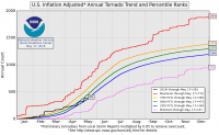
I'm also getting really tired of seeing this crap:

ab33440fd24af3967ae2d8c629cba8ca.png

Fourth straight year now of below-average tornado counts going through May (although you could argue 2012 was on its way out by this time with only March 2 and April 14 inflating the counts, making for this fifth straight year of this). What's it going to take to get an above average spring (or any fall season at all?)? Is it really asking so much to get a bumped up tornado count? Apparently it is.
 
Looking at the long range GFS / climate models and comparing to recent years, the closest analog for this year may end up being 2014. A pretty hefty ridge is looking to stay in place east for a while, and the trough pattern stuck over the mountains (but not quite getting fully ejected into the plains) will continue, as Jeff mentioned. The good news is that North/Central/High Plains chasers really benefit from this setup and the trough throws of pieces of energy every day or two. In addition, the central plains have been totally inundated with rain over the last month, so ground cover is saturated and will likely boost low level moisture for some time, unless there is a sudden heat wave.

I expect to see a couple of multi-day non-high-risk events over the central / high plains by the end of next week and into the first two weeks of June. The June 14 3-Day event was essentially 3 forecasted "slight" days in a row that all ended up moderates or high, and we will likely see a similar event play out this year. Don't feel bad if you don't see mods or highs on the SPC, as the best days in this setup tend to have very poor skill scores when forecasting. However you will have to pay more attention to meso-scale patterns, as they will tend to be the guiding light for any events that occur. As for those of you chasing in TX/OK, it might be another rough year. Blame it on climate change.
 
My vacation is booked for May 30-June 7. Bit of a downer seeing the CFS trend away from its 7+ supercell composite values it had been persistent in generating somewhere over the Plains/Midwest during that time frame, but it could still trend back. I agree with Jeff it would be nice to see a string of bigger days in the Plains. In the first decade of the 2000s it seemed every other year there'd be a week to 10 day stretch with about 3 high risk days, and persistent severe potential in between. We were lucky to get through that period without large-scale death and destruction until 2011, and that was the last year with such a period (but largely centered on Dixie Alley).

I wonder what the reasons are for the shift? It seems like each year there's been a different failure mode as to why most troughs do not result in a substantial chase-favorable severe weather event. 2012 was heat ridge city. 2013 winter held on into early May before finally giving way to an active severe pattern for the last two weeks of the month. 2014 also featured a persistent cool pattern, and events were often capped except right along the front up until Pilger day (which lined up perfectly with my vacation that year but I still blew it). Last year it seemed like the EML was TOO weak, so there were a lot of severe events but most of them mitigated by persistent early convection and/or destructive storm interactions. This year if it's not VBV, it's marginal moisture.

I've heard the term "PDO" bandied about a lot recently. I've been looking for a teleconnection with stronger correlation to central CONUS spring severe potential, as it seems the ties to ENSO are marginal at best. According to this article, if we are currently in an unfavorable PDO phase, maybe I can look forward to some epic chase seasons by the time I'm about 50. Yikes.

http://research.jisao.washington.edu/pdo/

According to this table, the month just finished (April 2016) had one of the highest positive PDO values observed.

http://research.jisao.washington.edu/pdo/PDO.latest

The index was also strongly positive for much of 2014 and 15, but it was also positive (to a lesser extent) during the treasured May of 2004. However it was negative during many other known active months such as April '91, May '99 and April '11. Hmmmm.

*Don't look now Jeff, but a fairly substantial trough now appears to be taking shape for the 25th-27th timeframe on the GFS. Funny how every time it shows a favorable severe pattern at that +200hr range I think "it's gotta be on to something," and every time it shows an unfavorable pattern I remind myself "it's basically a crapshoot at that range anyway."
 
Last edited:
Yeah so far this is my worst season since 2012. I've seen a few tornadoes, but nothing really worth remembering. At least most of my stuff has been pretty close to home so I haven't had to spend a ton of money this year. My next hope is that the upper Midwest (IE IA/IL/WI/MO) can somehow wake up in June/July again this year. I won't be holding my breath though. However I know it only takes one day to make one's entire season.
 
The 12z GFS/GGEM support a string of chase days next week for chasecationers and those with lots of money and time. Almost every day from Sunday onward to Thursday/Friday looks conducive to supercells somewhere on the Plains. It's late May, and moisture shouldn't be a problem, so photogenic tornadoes will probably happen on at least a couple days. Whether any of those days shapes up as a high end setup with obvious targets remains to be seen. Sunday has some potential in that regard, albeit flawed at the moment. This morning's runs are also hinting at next Thursday, but that's somewhat of a shift from earlier runs, and too far out to have any confidence.

Still, it's true that we've lacked for classic, synoptically-evident setups in the heart of chase season for a long time now. The 2010s have been pretty rough in that regard, especially since 2010-11. The type of pattern progged for next week isn't especially impressive for this time of year, yet I think my standards have fallen so far since 2011 that I'm excited for it anyway. Granted, the fact that the Plains are completely out of drought and evapotranspiration should be maximized gives some legitimate reason to be optimistic about upcoming "finesse" setups. Royce mentioned 2014 as an analog for the late season, and while that year was simply horrendous before Pilger, I'd argue several setups were severely compromised by drought. The kind of subtle setups seen on several days in late May and early June 2014 *might* have produced decent tornadoes without compromised BL moisture; but, of course, it's impossible to say for sure on any given day. Borderline deep-layer and/or low-level shear do matter, and chasing them constantly in the late spring can lead to frustration and fatigue, even if 1 out of every 3 or 4 such days come through.

On the topic of the PDO: the crude chase season scoring method I developed shows a clear negative correlation between chase season quality and the mean springtime PDO value. Last year was actually the highest-scoring season with a strongly positive PDO going back to 1955, with 2003 being one other example of a good year. By and large, though, the very highest scoring seasons saw neutral to negative PDO values. At the bottom end, there are a few horrid seasons with a -PDO, but awful +PDO seasons outnumber them. Some of the worst periods in chasing history, such as 1987-88 and 1996-98, coincided with a persistent strongly positive PDO. Suffice it to say, strong +PDO values are not what chasers should be hoping for in future seasons.

The incredibly persistent troughing and cold air over eastern Canada (at times extending into the US Great Lakes/Northeast) for the past 3-4 springs is even more concerning to me. I'm not a climate scientist, so I can't comment on how closely this might or might not be tied to the PDO, or what the causality might be in any such link. You can't help but laugh at recent global temperature anomaly maps showing rampant warmth over 80% or more of the world, but strong negative anomalies lodged over eastern North America, right where we don't want them.
 
Back
Top