State of the Chase Season: 2016 Edition

James Gustina

Supporter
Joined
Mar 9, 2010
Messages
671
Location
Dallas, TX
Seems like it's about time to get this thread up and going considering we're 10 days away from the end of March with a number of chases already occurring for some chasers across the Deep South. This thread can be used to talk about distant pattern shifts, how your season is going so far, climatology or anything else related to the 2016 chase season you can think of.
 
Season here in the Southern Plains has sucked so far. Of course were only a couple of days into spring. Long range models have a decent system or two coming in, but the moisture is lacking. Hopefully April can get things cranking up around here. Hell, I'd even get excited about a marginal risk in the area!
 
I'd be surprised if we don't start seeing a pattern shift by the second week of April but then again none of this is ever guaranteed to begin with. The development of drought in the northwest portion of Oklahoma and into the Panhandle is really the only worry right now other than the bomb of a low sitting in the Hudson Bay in late March.
 
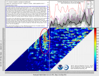
I'd like to comment on an observation comparing a string of CFS forecasts to the events of last week. Something that, to my knowledge, was unprecedented, happened. The CFS showed a pretty strong signal of conditions supportive of supercells with a pretty ridiculous lead time, extending up to 15 days or longer, for several days last week. While there were two days with come concentrated severe weather, one across northern Illinois, the other across parts of TX and the deep South, the areal extent of the severe weather coverage seemed to be severely overforecast. Greg Carbin's chiclet chart, pasted below, illustrates this anomaly pretty well:

cfs_bchiclet.png

This chart has been produced regularly for over two years now. I've seen many instances where it falsely predicts a day or two of potential severe weather conditions even a few days out. There was also a shockingly poor lead-time forecast for the severe weather event that occurred in late February in the deep South (barely any highlights on the chart for forecasts verifying 2/22 or 2/23). But this is the first time I think I've seen such a strong and consistent signal of severe weather from the CFS over a multi-day period with such large lead time that did not really verify. Conventional wisdom says that if a large-scale model is that consistent on a pattern or specific event, then it has a high probability of verifying. However, sampling uncertainty also says that even if an event has a 95% probability of occurrence, it will not occur 5% of the time. So maybe this was one of those events. Still impresses me just how far out in time the signal appeared (15-20 days).

Using the chart to look out over the next few weeks, it looks more like a typical climatological signal for early spring: fairly random out past day 5-10, but a lot of days with higher grid point counts. So really there is no strong signal indicating a particularly active or inactive period lies ahead. The ERTAF system is somewhat consistent, although I see a prediction of somewhat below average tornado activity for the week spanning the very end of March and heading into very early April.
 
So far 2016 is starting off pretty well for me, I'm batting 1/1 with already one tornado under my belt (only 2nd March tornado!). This is the best start since 2012 for myself. Not saying much considering the season, just started, but I'm hoping that it continues nicely! If anything, I'll always have June here in the upper Midwest to look forward to. :)
 
I got far too excited looking towards the start of next week and of course was disappointed when I realized a moisture-cratering cold front comes in over the weekend and slowly shunts the moisture away from the coast. before we get a decently large, high-amplitude trough moving into California. The GFS has been a bit more progressive with the trough so hopefully the ECM wins out and a slower solution prevails which would leave the door open for the slightest possibility of moisture making it far enough north ahead of the lead jet streak.
 
I don't see any large scale signs that the overall pattern of the last 8-10 years or so is going to change anytime soon. Drought and lack of sig. svr. in the W/SW regions (LBB, MAF, AMA, DDC, etc.) and a few major events along a sharp dryline just east of a OKC, ICT to GRI line. Isolated events in NE Colorado like last year. This is a global pattern shift and until I start seeing a little snow on the ground as I travel through the eastern mountains of NM in late April or early May, I'm not too excited. Mother Nature works in strange and mysterious ways!
 
I'd be hesitant in getting too concerned this early since Nino springs are climatologically late starters in the Plains with much of their activity concentrated in May and June (often due to the sub tropical jet suppressing moisture southward early in the season).
 
I'm a little bummed out. I'll be in Texas this coming Saturday until the following Saturday. It looks like moisture is going to betray me of a bonus chase to two. Oh well, I still have May to look forward to.......


Sent from my iPad using Stormtrack mobile app
 
Saw one storm so far. I didn't need to chase it of course as it was only 15 miles away (but it rapidly fizzled out as I was watching it). Otherwise, nada. I'm hoping I could go chasing in the second half of may after I graduate. :D
 
I'd be hesitant in getting too concerned this early since Nino springs are climatologically late starters in the Plains with much of their activity concentrated in May and June (often due to the sub tropical jet suppressing moisture southward early in the season).
It's early in the season, very early. We've been "spoiled" with a near climo (at times, seemingly above climo) severe pace thus far in 2016. It's likely to quiet down for a time in early April, which is not unusual, whatsoever. I'm still optimistic about late April, but we'll see how things go. I am not worried about drought conditions right now in the High Plains either. It's a relatively small area in a short-term drought. The abundance of moisture in East Texas and the lower Mississippi Valley over the past month or so should offset any "dry" concerns. If anything, perhaps this works to sharpen the dryline, and/or favor more LP events, as opposed to HP.

I'm not necessarily a big fan of El Niño analogs for this April, as the results and similarities are mixed. I had trouble correlating the late winter pattern in this El Niño with other notable El Niño winters and there seems to be a lot variability. (I have a more optimistic look at the month based on what I've seen) 2008 has been a decent analog for a number of reasons.
  1. The upper air pattern we've seen over the past few weeks. (Only caveat/setback is the eastern Canada/Great Lakes troughing progged for early April 2016, while 2008 basically flipped into a spring pattern quickly, with only a short-lived eastern NA trough around 4/12-16)
  2. March 2008 was also dry across the southern Rockies/High Plains with very steady severe activity from February through part of June.
  3. Expectation that eastern U.S. ridging returns during the second half of April 2016.
  • The Euro weeklies have been very consistent in flipping the pattern by mid-April.
  • Although less reliable, the CFS tends to agree.
One could also point toward 2011 and 2012 for active early fire weather seasons that coincided with big severe events in April. I tend to favor an April that starts slow and then sees a fairly steady stream of potential events from weeks 2-5. Essentially, I think it is more likely that we see several small-moderate events, as opposed to one particularly major outbreak.

Back with the analogs...the troughing pattern projected for early April is flagging several analogs with 1990. That April was below average for tornadoes, but saw active months in May and June, along with the Ohio Valley outbreak in early June. That was a weak El Niño winter, but seems like another plausible scenario

The bottom line is that I see a lot of mixed signals, however, the evidence tends to point toward an at or above average spring, especially later in the season, as opposed to the beginning. It may not be scientific, but we've also seen several over-performing events this year and a nearly steady stream of threats on a weekly basis since late June.

The only seasons with more tornadoes YTD through March 22 over the past 11 years are 2002 and 2006-08. We're in good company... I think this may be the year to finally break the post-2011 doldrums. I also doubt that this spring dies as suddenly as 2012 did.
 
Back
Top