Shades of 2013?

IMO, the sparse seasons are OK with me as long as I can get out there for the good days. I can't afford do a 2004-type season every year even if they did happen all the time. I'd have to pick and choose which days to go and which days to miss, which to me would seem harder/more annoying.
 
While I would prefer the season start off a little sooner than it has the last couple of years, my hope is that it will just add it to the back end in June like last year but still be active in regular intervals instead of the concentrated days of the last couple of years. But it's hard to argue the quality of tornadoes the last two years have brought.
 
It's hard to be optimistic - especially considering how the last few years have gone.

A couple things to consider as differences between 2013 and this year that "might" ultimately play a role in what happens in the next couple of months...

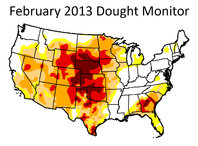
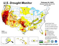
As you remember, in 2013 there was a significant ongoing drought in place for much of the plains. This year, there is some drought, especially in the southern plains but it's not nearly as bad (at least it isn't as bad in the plains, the southwest USA is another story). Here are the 2013 and 2015 drought monitors for this time frame:

February-2013-drought.jpg 20150224_usdm_home.png

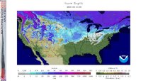
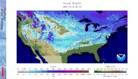
Also, the current snow depth between 2013 and this year is significantly different for the northern states. How much of a role this will play will be interesting. It leads me to believe the northern states will warm up quickly though. Here are the snow depth maps from 2013 and 2015 for this time frame:

nsm_depth_2013030105_National.jpg nsm_depth_2015030105_National.jpg

Will these things make any significant difference with how things play out? Who knows, hopefully it is not a repeat of 2013 though...
 
Last edited by a moderator:
Jeremy, I would like to see a repeat of 2013 from the standpoint of rain in Oklahoma. During the 2 weeks I spent out here in August looking for a job, I saw rain nearly every night. I haven't seen the Cimarron that high since probably the summer of 95.

I think we've had more moisture this winter in OK than we did in 2013. We certainly aren't having the wildfires that we had last year at this time. For that I am grateful. I, for one, will just wait and see. This is Oklahoma after all. I've learned over the years to never rule anything out.
 
I"m more worried about El Nino. I"m not the first one to say there is a correlation between that and decreased large tornado outbreaks.
 
El Nino has attributed to some of the best tornado seasons to date. Most recently 2007 and 2010. Maybe it sucks for you up in the Northeast but remember that the people on this site are largely based out of the Plains.
 
What do you think about this being a negative feedback loop kind of deal? For example, the cold winter cools bodies of water and lays snowpack which then alters spring and summer weather patterns.

For example, the extreme great lakes ice coverage the last few years has significantly cooled the spring and summer weather in the states surrounding.

Just a thought - probably doesn't affect the central plains all that much but who knows? That abnormal cold in the midwest could effect things nationwide.
 
I was curious about the breakdown of tornadoes in 1995 and found this - http://en.wikipedia.org/wiki/Tornadoes_of_1995. It looks as though it was a decent April and then a really good May with almost 400 tornadoes that month. Yet all anyone remembers that year is the one week here in the TX Panhandle. June only had 192 tornadoes, half of what May had. For people who love analogs, the 1995 and 2015 tornado count is pretty close so far. January - 1995:36 2015:26. February - 1995:7 2015:2.

The thing with the 2007 season, we were actually leaving an El Nino and not venturing into one.
 
Happy meteorological spring everyone! Now where are those storms?

10994163_10101314208607431_4170023164862208572_o.jpg
Dude, that's hilarious...:D
 
In my short time keeping track, I've noticed transition years to be the most volatile, I believe this was the case in 2008, 2010 and 2011 as well (someone can prove me wrong) the year may have been leaning slightly one way or another, but in those cases the trends were heading towards the other side. To me it makes sense since there would be more of a battleground going on as opposed to years where we were firmly locked into one or the other with a dominant pattern taking hold.
 
Here's a paper worth reading regarding tornado activity and fluctuations in equatorial Pacific SSTAs. Note that the Trans-Nino Index outlined here doesn't really tell how active overall a season will be, but instead suggests that more violent events on a shorter timescale may be possible in a positive phase. We are currently in a negative phase with cooler waters in Nino 1+2 and warmer anomalies in Nino 4 and have been since July 2012.

http://cpo.noaa.gov/sites/cpo/Webcasts/MAPP/2013/Presentations/1-15/Lee.pdf
 
In my short time keeping track, I've noticed transition years to be the most volatile, I believe this was the case in 2008, 2010 and 2011 as well (someone can prove me wrong) the year may have been leaning slightly one way or another, but in those cases the trends were heading towards the other side. To me it makes sense since there would be more of a battleground going on as opposed to years where we were firmly locked into one or the other with a dominant pattern taking hold.


Hoping that this year proves to be busy, it seems like we have had a couple different patterns this winter, so something changing seems pretty probable.

Thanks for all the input and feedback guys
 
Back
Top