• After witnessing the continued decrease of involvement in the SpotterNetwork staff in serving SN members with troubleshooting issues recently, I have unilaterally decided to terminate the relationship between SpotterNetwork's support and Stormtrack. I have witnessed multiple users unable to receive support weeks after initiating help threads on the forum. I find this lack of response from SpotterNetwork officials disappointing and a failure to hold up their end of the agreement that was made years ago, before I took over management of this site. In my opinion, having Stormtrack users sit and wait for so long to receive help on SpotterNetwork issues on the Stormtrack forums reflects poorly not only on SpotterNetwork, but on Stormtrack and (by association) me as well. Since the issue has not been satisfactorily addressed, I no longer wish for the Stormtrack forum to be associated with SpotterNetwork.

    I apologize to those who continue to have issues with the service and continue to see their issues left unaddressed. Please understand that the connection between ST and SN was put in place long before I had any say over it. But now that I am the "captain of this ship," it is within my right (nay, duty) to make adjustments as I see necessary. Ending this relationship is such an adjustment.

    For those who continue to need help, I recommend navigating a web browswer to SpotterNetwork's About page, and seeking the individuals listed on that page for all further inquiries about SpotterNetwork.

    From this moment forward, the SpotterNetwork sub-forum has been hidden/deleted and there will be no assurance that any SpotterNetwork issues brought up in any of Stormtrack's other sub-forums will be addressed. Do not rely on Stormtrack for help with SpotterNetwork issues.

    Sincerely, Jeff D.

Biggest Slight Risk outbreaks

June 1, 1999

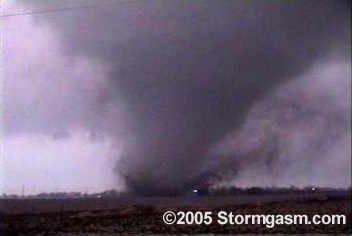
This event had a slight risk which extended from IL southwest into eastern OK and northeast TX. Several tornadoes were reported in IL, while an intense supercell developed in eastern OK and drifted south/southwest as it continued to backbuild into the Theta-ridge. This storm produced 7 or 8 tornadoes including an F2 in Muskogee and two F3 tornadoes (one at Sequayah State Park and the other near Checotah.
 
because they are forecasting for the public, not storm chasers.

This is truth. The NWS uses several different models, and as we've seen this year, the models can diverge significantly until and including the day of the storms. Often, for very strong storm days, the NWS will issue a SLGT until several model elements verify.

Before the day of a chase, models are all anyone has. For me, they are good only to the extent of figuring out where to set up, or approximately where to crash for the night if the chase is going to be a long-distance one.

It is not of course for chasers - as a chaser for the first time this year, I've had to ask myself things the SPC won't tell you all the time. What does the terrain look like? Are the storms going to be moving 65 mph? Is the event going to be primarily at night, when I can't see?

If you're going to use the SPC as a guidebook, as it should be used, they might issue a SLGT even though a very localized tornado event may occur - something you might miss if you "don't feel like chasing a SLGT." I check the models, opinions from other chasers here, and my own hunches before the day - then on the day itself, we set up our best guess and go by our eyes from there.

To contribute to the thread, I of course haven't remembered very much, since stormchasing is new for me, but the aforementioned January outbreak was SLGT if I recall correctly, and I believe included a tornado (in Wisconsin) out of the area entirely. If you're strictly speaking, '99 can't be considered a SLGT, since it was upgraded (although during the day-of).
 
Nov. 12, 2005 tornado outbreak unfolded over Central Iowa. I believe there were over a dozen tornadoes reported in Iowa that day. SPC had a slight risk all day. Below is the Aimes/Gilbert, Iowa tornado.

still1.JPG
 
I remember last June we had a really nice storm and not a bad outbreak around Ness County Kansas that was only a slight risk.. It had me kicking myself we did not make the drive out there because the SPC downplayed it quite a bit! It wasn't a huge outbreak but I thought it warranted a moderate risk atleast!


Unfortunately my memory usually only remembers the big outbreaks, and when the SPC forecasted a Mod or High that didnt pan out at all!
 
May 12, 2004: South Central KS Tornadoes, but one should not judge a chase day on SPC outlooks; outlooks are for NWS offices not chasers.

I'm not sure I understand your comparison... I don't think an outbreak occuring in a slight risk area can be considered a hit no matter how you define their forecasts? The question wasn't about 'slight risk chase days' but 'slight risk outbreaks'.
 
Back
Top